Extreme Heat Across the Southern U.S.; Flash Flooding Threats in the Mid-Atlantic, Northeast, and Four Corners Region
Dangerous and extreme heat will remain across portions of the southern U.S. this week. Heavy rainfall may bring significant flash flooding across portions of the Mid-Atlantic and Northeast through the night, and additional flash flooding concerns across New England on Wednesday. Monsoonal thunderstorms will bring a flash flood risk to the Four Corners region, especially in burn scar areas
Read More >
LOADING...
Greenville-Spartanburg, SC
Weather Forecast Office
Becoming Severe Weather Ready in the Western Carolinas and Northeast Georgia
Here in the Western Carolinas, we receive our fair share of thunderstorms. This is due to our proximity to the Gulf of America and the Atlantic Ocean, which provide two sources of warm, humid air in the warm season. The mountains also play a role in our thunderstorm frequency, as air flowing around and up mountain slopes can provide the lift that is required to push the unstable air up into the atmosphere. On days when the atmosphere is particularly unstable, some thunderstorms may become severe.
Damaging wind gusts are the most common form of severe weather across the western Carolinas and northeast Georgia. Damaging wind gusts, often called “downbursts,” form in association with the downdraft. They are caused when sinking air within the downdraft accelerates toward the surface, then spreads horizontally away from the storm after impacting the ground.
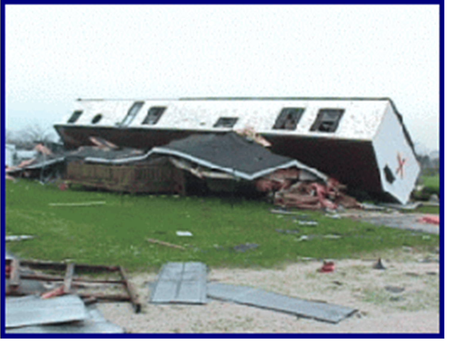
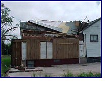
Although most downbursts cause wind gusts of around 60 mph, speeds of 100 mph or more are possible. Wind gusts of this magnitude can cause extensive damage to trees, power lines, and manufactured homes. This is equivalent to the wind speeds produced by weak tornadoes. This is a very important point: downbursts can produce damage similar to a weak or even moderately strong tornado. The peak time of year for downbursts across the region is June
Fig. 4. Although the damage in these photos may appear to be the result of a tornado, it was actually caused by downbursts. Downbursts can produce damage similar to a tornado, and are quite common across the western Carolinas and northeast Georgia. This is why severe thunderstorm warnings should be heeded.
and July. They are especially common in the piedmont. A typical piedmont county experiences at least one event on four to seven days per year.
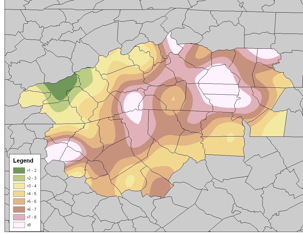
The second most common form of severe weather across the Carolinas and northeast Georgia is large hail. Hail is simply ice that develops in the upper levels of a tall thunderstorm, where temperatures are well below freezing. The strong updrafts
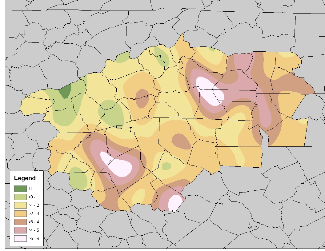
Fig. 5. (Left) Same as in Fig. 3 except for large hail. (Right) The number of days with hail the size of a golf ball or larger within 200 square miles of any point from 1995 to 2008. Click images to enlarge.
strong updrafts associated with such storms suspend ice particles aloft within the storm’s core. These suspended hailstones are subject to collisions with other ice particles. These collisions cause the hailstones to grow. Eventually, the hail will become too large and
heavy for the updraft to support. allowing the hail to fall to the ground via the downdraft. Large hailstones across the western Carolinas and northeast Georgia rarely exceed the size of a quarter. However, hail as large as softballs has been reported across the area as recently as 2011.
In this region, large hail is most common in the piedmont of the western Carolinas, where two to four days of large hail are observed in a given year. Hail that is the size of a golf ball or larger is quite rare, but is observed on about one day per year across the piedmont. The peak time of year for large hail is May and June.


 Hourly Weather