
Dangerous and extreme heat will remain across portions of the southern U.S. this week. A heat wave over the Southwest U.S. will intensify this week, peaking and expanding into the Intermountain West and northern High Plains this weekend. Multiple rounds of thunderstorms will produce heavy to excessive rainfall with significant flash flooding across portions of southern New England today. Read More >

Fig. 1. A “shelf cloud,” representing the leading edge of air spreading horizontally away from a thunderstorm downdraft. Wind gusts of 60 mph or more would likely be experienced along the leading edge and just to the rear of this cloud formation.
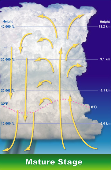
Fig. 2. Schematic of a mature thunderstorm, depicting the updraft (yellow arrows pointing toward top of the page) and the downdraft
A thunderstorm may eventually grow to a height of 50,000 feet or more before it stops developing. Generally speaking, the “taller” the storm, the more likely it is to produce violent weather.
Thunderstorms are characterized in two ways: general and severe. A Severe thunderstorm is one that produces large hail (i.e., one-inch diameter or larger), damaging wind gusts, and/or tornadoes.


 Hourly Weather