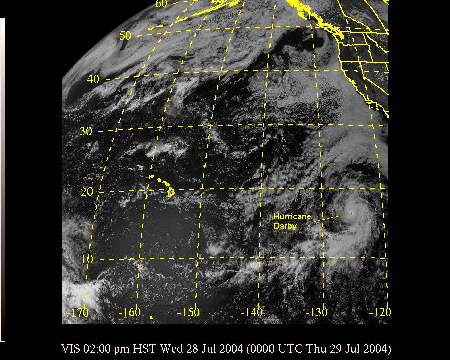
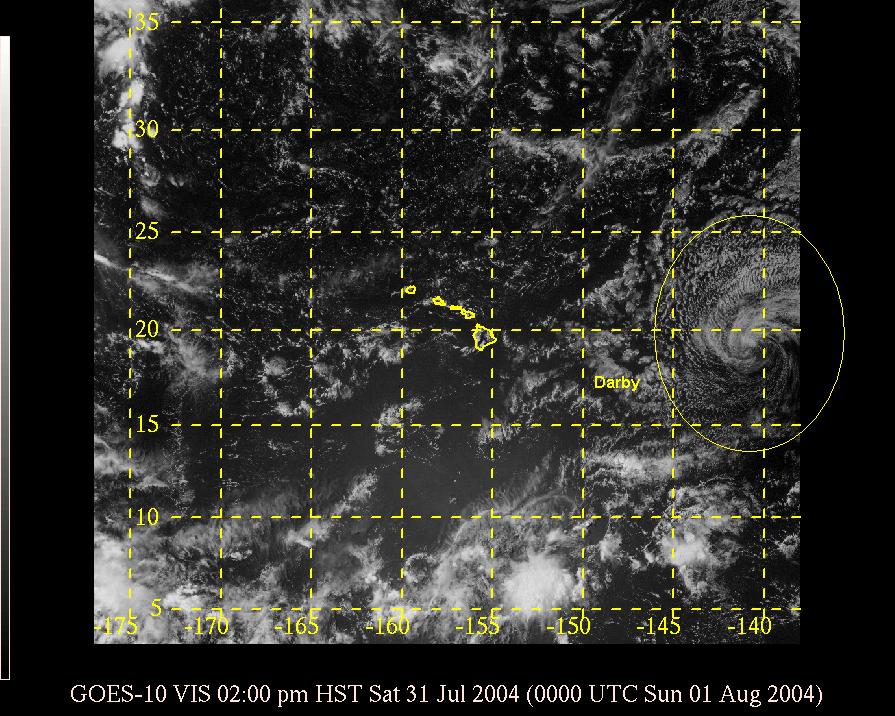
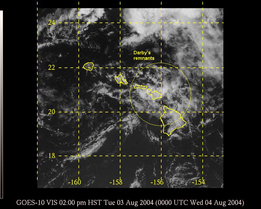
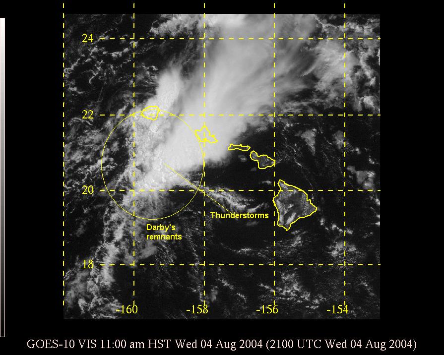
What would eventually become Hurricane Darby developed about 2800 miles east-southeast of Hawaii on July 26, 2004. Moving to the northwest and then west, Darby ultimately reached peak intensity of 105 kt (120 mph) on July 29 (satellite). Shortly thereafter, Darby moved into an area of cooler waters and stronger upper level winds, both are unfavorable for a hurricane to sustain itself. Just two days later, Darby was nothing more than just a low level swirl of clouds and showers with winds of only 20 to 25 knots as it was about 1000 miles east of the state (satellite). This area of moisture was being pushed westward toward Hawaii by the tradewind flow.
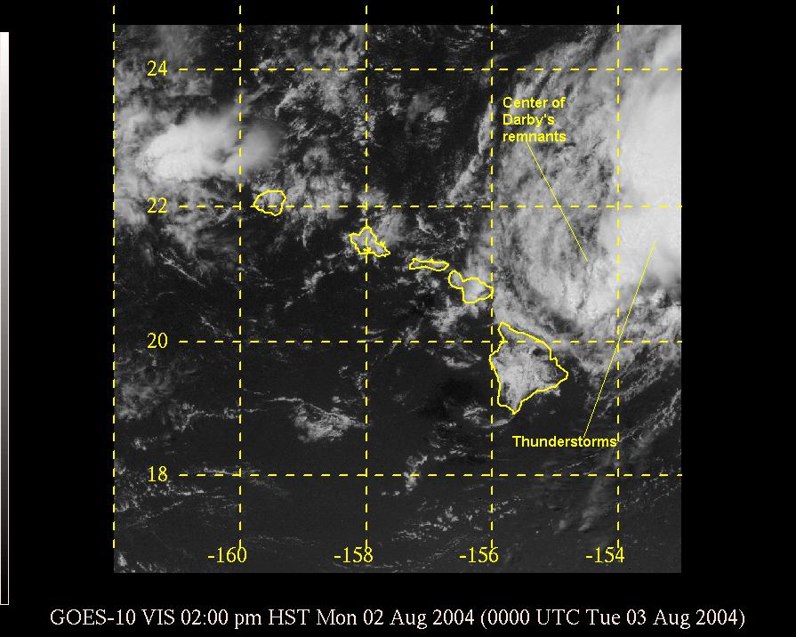
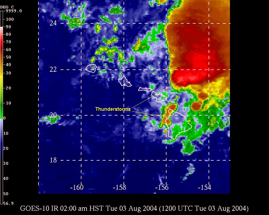
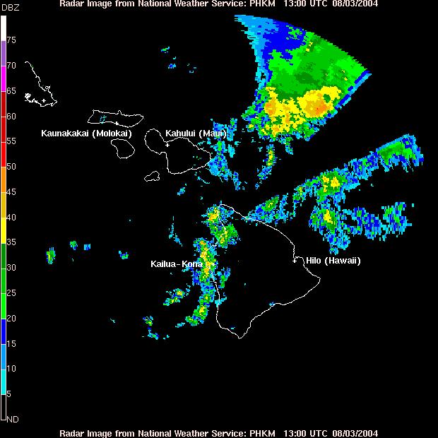
An upper level low was located just to the northwest of the state, and this had made the atmosphere slightly unstable over Hawaii. As the remnant swirl of Darby moved closer to the unstable region, thunderstorms began to develop. The first round of thunderstorms occurred just north and east of the Big Island on August 2 (satellite). That night, additional showers and thunderstorms formed across parts of the Big Island, particularly the normally dry Kona side (satellite, radar). Rainfall amounts of 2 to 5 inches over a few hours were reported, and this led to flooding and closures of several roads.
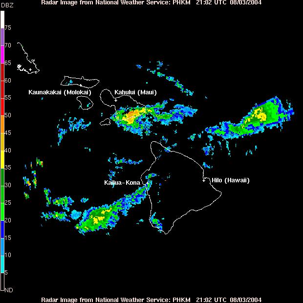
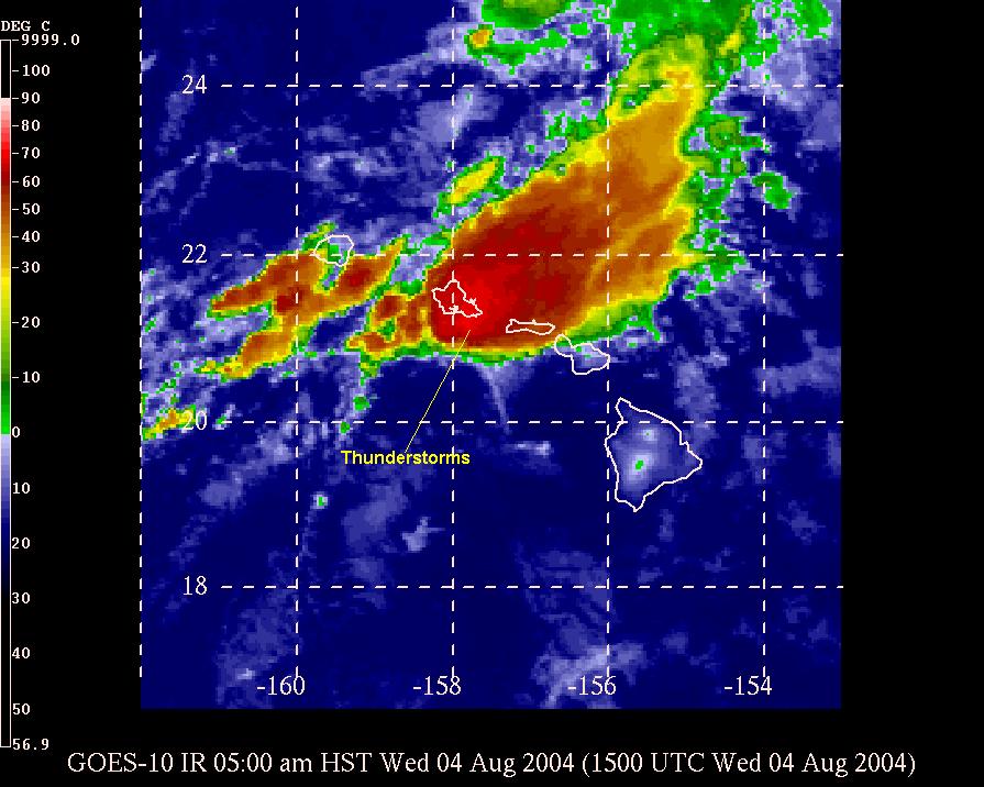
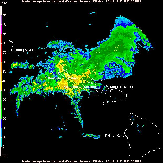
During the day on August 3, the remnants moved across Maui (satellite, radar). Locally heavy rainfall occurred on the southeast flank of Haleakala, otherwise the development of heavy and widespread rainfall was limited. However that changed during the night as the remnants approached Oahu. Once again thunderstorms developed, affecting the entire island of Oahu and dumping several inches of rain in a few hours (satellite, radar). A few streams overflowed their banks and minor landslides occurred, both resulting in some road closures. The main effect was significant ponding of water on the roads, which impacted the morning rush hour. By mid day August 4, Darby's remnants began to affect Kauai (satellite), but the bulk of the heaviest rainfall stayed south of the island, thus sparing the island from any heavy rains, with the exception at the normally wet Mount Waialeale.
Heavy rains during the summer are very unusual, especially on the drier leeward sides of the islands. In fact, the heavy rainfall was a record in Honolulu. The Honolulu Airport recorded a total of 3.06 inches from the storm, 2.92 inches which fell on August 4. This was the heaviest one day rainfall for the entire month of August. The previous record being 2.10 inches that fell on August 6, 1959 as Hurricane Dot was passing by. This heavy rainfall also pushed the monthly rainfall total at Honolulu above the previously wettest August since 1949. The previous record was again in 1959 when 3.08 inches fell for the entire month. Normally the Honolulu Airport gets only one-half inch of rain during August and 3 inches during the entire dry season (May through September).
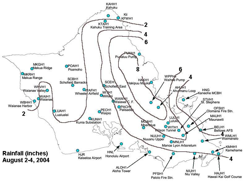
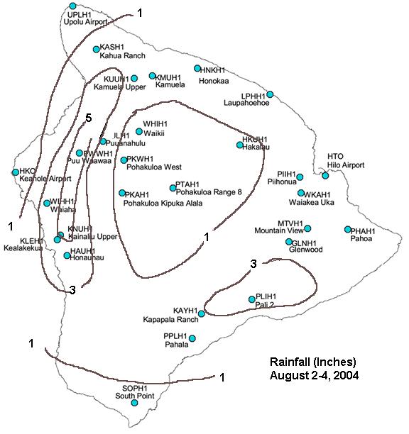
Here are selected rainfall amounts at rain gauges for the period August 2-4.
| Island Of Kauai | |
|---|---|
| Site | Rainfall |
| Mount Waialeale | 8.02 |
| Wailua | 3.22 |
| Lihue Var. Stn. | 2.22 |
| Kapahi | 2.10 |
| Hanalei River | 2.05 |
| Omao | 2.02 |
| Kalaheo | 2.02 |
| Poipu | 1.96 |
| Wainiha | 1.74 |
| Hanalei | 0.98 |
| Kokee | 0.78 |
| Hanapepe | 0.77 |
| Island Of Oahu(map) | |
|---|---|
| Site | Rainfall |
| Waihee Pump | 9.04 |
| Ahuimanu Loop | 8.80 |
| Punaluu | 7.82 |
| Hakipuu Mauka | 7.62 |
| St. Stephens | 6.24 |
| Luluku | 6.22 |
| Wilson Tunnel | 6.21 |
| Hawaii Kai Golf Crse | 5.62 |
| Manoa Lyon Arboretum | 5.57 |
| Moanalua | 5.04 |
| Maunawili | 5.00 |
| Schofield | 4.60 |
| Waimanalo | 4.44 |
| Pearl City | 4.37 |
| Olomana Fire Station | 4.23 |
| Kamehame | 4.22 |
| Palisades | 4.17 |
| Barbers Point | 3.85 |
| Waiawa | 3.72 |
| Aloha Tower | 3.68 |
| Waipio | 3.51 |
| Palolo Fire Station | 3.40 |
| Mililani | 3.38 |
| Kapolei | 3.22 |
| Honolulu Airport | 3.06 |
| Wheeler Airfield | 2.90 |
| Bellows AFS | 2.78 |
| Waianae Valley | 2.21 |
| Pupukea | 2.13 |
| Kunia Substation | 2.11 |
| Lualualei | 1.84 |
| Makua Ridge | 1.75 |
| Poamoho | 1.73 |
| Waianae | 1.72 |
| Kahuku | 1.59 |
| Kaneohe Marine Corp Station | 1.53 |
| Island Of Molokai | |
|---|---|
| Site | Rainfall |
| Molokai Airport | 1.35 |
| Island Of Lanai | |
|---|---|
| Site | Rainfall |
| Lanai City | 1.39 |
| Island Of Maui | |
|---|---|
| Site | Rainfall |
| Kaupo Gap | 5.05 |
| Oheo Gulch | 3.82 |
| Ulupalakua | 2.24 |
| Kahakuloa | 1.38 |
| Haiku | 1.21 |
| Island Of Hawaii (map) | |
|---|---|
| Site | Rainfall |
| Puu Waawaa | 5.56 |
| Kainaliu Upper | 5.10 |
| Kealakekua | 4.53 |
| Volcano Park | 4.41 |
| Honaunau | 3.18 |
| Waiaha | 3.00 |
| Kapapala Ranch | 2.66 |
| Hilo Airport | 2.51 |
| Kahua Ranch | 2.50 |
| Laupahoehoe | 2.37 |
| Mountain View | 2.30 |
| Kamuela | 1.29 |
| Pahala | 0.98 |
| Keahole Airport | 0.61 |

