Hurricane Douglas is the closest a hurricane has come to Oahu since before Hurricane Dot in 1959
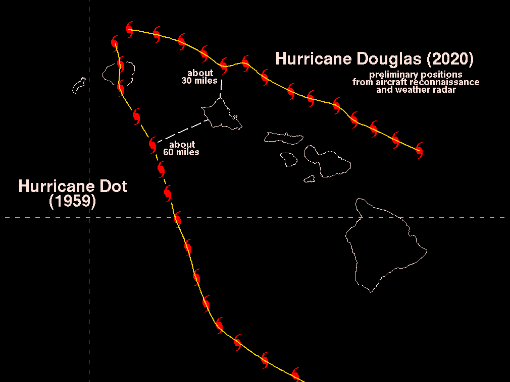 Preliminary center fix data from U.S. Air Force Reserve Hurricane Hunters and weather radars indicate that the center of Douglas passed about 30 miles north of Kahuku around 7 pm on Sunday. This appears to be closer than Hurricane Dot, which passed approximately 60 miles southwest of the Waianae Coast on Oahu before making landfall on Kauai in August of 1959.
Douglas was encountering some wind shear as it approached the islands. Also, the islands were on the left side of the track of Douglas with respect to its west-northwest motion. The combination of these two fortuitous outcomes kept the worst of the weather associated with Douglas just offshore of all the islands. Satellite, radar, and aircraft reconnaissance data indicate that tropical storm force winds were within about 10 miles of the northern tip of Oahu during the closest approach of Douglas.
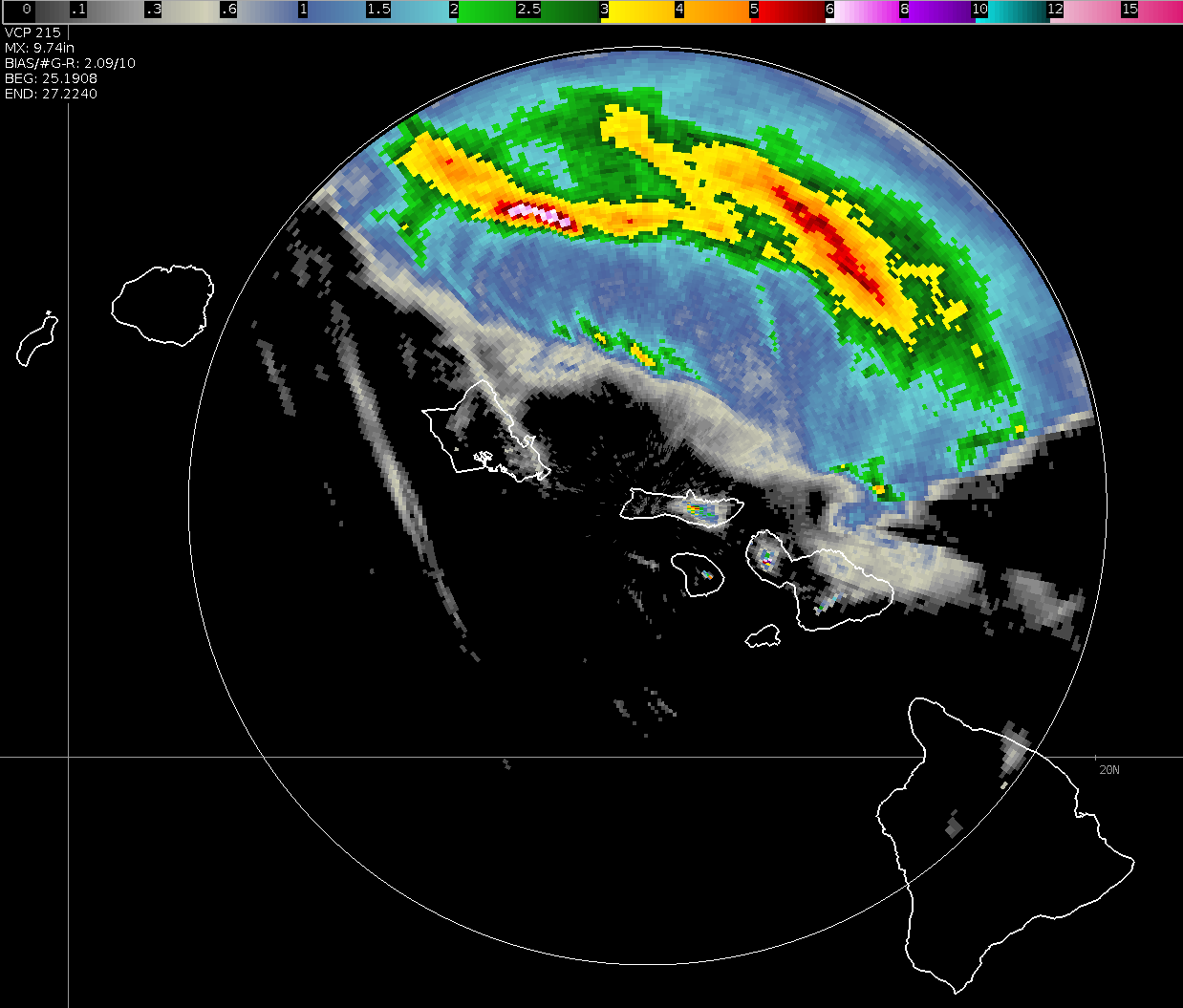
The image below is radar-derived storm total precipitation from the weather radar on Molokai. It shows cumulative rainfall estimated by the radar from 9:08 am HST Saturday 7/25 through 12:40 pm Monday 7/27. Widespread rainfall was located along and to the north of the track of Douglas. A maximum value of near 10 inches was located just 50 miles north of Oahu.
While the islands were fortunate this time, it is still relatively early in Hurricane Season 2020. We encourage everyone to remain prepared, and always have a disaster preparedness kit ready for the next hurricane threat.
Here are the preliminary rainfall and highest wind gusts reported across Hawaii over the last 24 hours ending at 800 am Monday, July 27, 2020. Observations are collected from a variety of sources with varying equipment and exposures. We thank all volunteer weather observers for their dedication. Not all data listed are considered official.
...PRECIPITATION REPORTS...

Location                     Amount

...Hawaii...

...Hawaii County...
Paauilo 2.4 SW               2.06 in
Paauilo 3.0 SW               2.02 in
Honokaa                      1.84 in
Kamuela Upper (15002)        1.81 in
Honokaa 4.2 SSE              1.70 in
9.1 E Mauna Kea Summit       1.61 in
Hakalau                      1.61 in
Paauilo 4.1 WSW              1.55 in
2.4 NE Kamuela               1.52 in
0.6 N Honaunau               1.40 in
Puu Mali                     1.31 in
Honokaa 2.7 ESE              1.25 in
Kealakekua                   0.79 in

...Honolulu County...
0.7 SE Punaluu               2.76 in
Kahuku                       2.13 in
Kii                          1.45 in
Kailua                       1.40 in
1.9 SE Turtle Bay            1.39 in
2.0 NE Makaha Valley         1.25 in
Waianae Valley               1.25 in
2.8 NE Waianae               1.23 in
Kahuku Training Area         1.19 in
1.5 S Maunawili              1.16 in
Nuuanu Upper (13007)         0.90 in
Moanalua (13003)             0.86 in
2.0 SW Kaaawa                0.75 in
3.9 S Hauula                 0.75 in

...Kauai County...
Kapahi (12003)               3.69 in
Kilohana                     3.68 in
3.7 S Na Pali State Park     2.90 in
Mount Waialeale Rain Gauge   2.86 in
6.8 SE Kokee State Park      2.65 in
Anahola (12001)              2.03 in
N Wailua Ditch (USGS)        1.76 in
Kapaa 2.3 SW                 1.67 in
3.5 SW Kapaa                 1.56 in
Makaha Ridge                 1.43 in
Kapaa                        0.94 in
2.8 NW Hanamaulu             0.77 in

...Maui County...
Puu Kukui                    5.16 in
4.7 NE Launiupoko            3.28 in
Kula Branch Station          2.27 in
2 NE Kula                    2.04 in
0.7 E Pukalani               2.01 in
3 SE Makawao                 1.92 in
Molokai 1                    1.92 in
3 ENE Makawao                1.75 in
Puu Alii                     1.61 in
5.0 E Kaunakakai             1.58 in
KH6HHG Makawao               1.29 in
1.0 E Lahaina                1.29 in
3.3 S Keanae                 1.25 in
Kula 1                       1.19 in
Hana Airport                 1.14 in
1 SE Pukalani                1.02 in
Kula                         0.89 in
Haiku (14001)                0.85 in
Haiku                        0.79 in


...HIGHEST WIND REPORTS...

Location                     Speed

...Hawaii...

...Hawaii County...
Nene Cabin                   70 MPH
15 S Pohakuloa Camp          40 MPH
PTA East                     37 MPH
Bradshaw Army Airfield       36 MPH
Kaupulehu                    34 MPH
Kahuku Ranch                 34 MPH
PTA Range 17                 33 MPH
Hilo Airport                 30 MPH
Hilo                         29 MPH
Honokaa                      26 MPH
Hilo (NOS-NWLON)             26 MPH
Pohakuloa Keamuku            25 MPH


...Honolulu County...
Kuaokala                     55 MPH
Laniakea                     41 MPH
Kaneohe Mcas                 36 MPH
Makapuu Beach                36 MPH
Kii                          32 MPH
Palehua                      31 MPH
Waianae Valley               31 MPH
Mokuleia                     30 MPH
Honolulu Airport             29 MPH
Honolulu                     28 MPH
Kailua                       28 MPH
Punaluu                      28 MPH
Kahuku Training Area         27 MPH
Makua Ridge                  27 MPH
Wheeler Air Force Base       26 MPH
Kalaeloa Airport             25 MPH
Schofield Barracks           25 MPH

...Kauai County...
Barking Sands                39 MPH
Lihue Airport                36 MPH
Mana                         30 MPH
Kapaa                        29 MPH
Makaha Ridge                 26 MPH
Puu Opae                     26 MPH

...Maui County...
Kula 1                       69 MPH
Kaneloa                      48 MPH
Lanai Airport                45 MPH
Molokai Airport              39 MPH
Molokai 1                    37 MPH
Kanaha WF                    37 MPH
AH6GR Maui                   36 MPH
Lanai 1                      35 MPH
Kealia Pond Nwr              33 MPH
Kahului Airport              33 MPH
Makapulapai                  32 MPH
Hana                         26 MPH
Kapalua Airport              26 MPH

...Maritime Stations...
Molokini Light               49 MPH
Nawiliwili (NOS-NWLON)       44 MPH
Mokuoloe (NOS-NWLON)         31 MPH

