 A kona low developed late on November 28 several hundred miles northwest of KauaÊ»i. Bands of mainly light to moderate rainfall produced 1 to 3 inches of rain over KauaÊ»i and OÊ»ahu on November 28 and 29. Only minor flooding issues were reported from this rainfall. At this time, the main axis of deep tropical moisture, and the most intense rainfall, remained east of the Big Island. The axis shifted westward on November 30, resulting in a significant increase in rainfall over the southeastern half of the Big Island and the eastern and southern flanks of HaleakalÄ on Maui. Flash flooding closed the HÄna Highway at several locations between PaÊ»uwela and HÄmoa, and along PiÊ»ilani Highway between Kahikinui and KaupÅ. Heavy rainfall during the morning of November 30 on the Big Island resulted in the closure of Wood Valley Road near PÄhala, and PÅhaku Drive in Orchidland Estates near KeaÊ»au. Combined rain gage and bias-adjusted radar rainfall estimates showed 11 to 22 inches over the eastern portions of the Big Island and Maui from the kona low. The PÄhoa Beacon automated rain gage recorded peak rain rates in excess of 4 inches per hour during the morning of November 30.
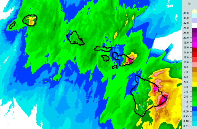
The image on the right is from the Multi-Radar/Multi-Sensor (MRMS) quantitative precipitation estimates (QPE) for the 72 hour period ending at 8 am HST, Friday, December 1. The color scale is on the right, in inches of rainfall.
The following are notable automated rain gage totals for the 3- day period ending at 8 AM HST, December 1. All amounts are in inches. These totals are considered preliminary for information purposes only.
Location                             3-day total

Kauai
WLLH1 Mount Waialeale (USGS)             4.38
KHEH1 Kalaheo                            4.35
WKRH1 Waiakoali (USGS)                   4.25
WUHH1 Wailua                             4.07
MCRH1 Mohihi Crossing (USGS)             3.96
PLRH1 Puu Lua                            3.79

Oahu
MAUH1 Maunawili                          3.64
OFSH1 Olomana Fire Station               3.24
STVH1 St Stephens                        3.17
HAKH1 Hakipuu Mauka                      2.81
MOGH1 Moanalua RG (USGS)                 2.71
AHUH1 Ahuimanu Loop                      2.68

Maui County
WWKH1 West Wailuaiki (USGS)             11.15
KLFH1 Kula 1                             3.89
KPNH1 Kepuni (USGS)                      3.39
LANH1 Lanai City                         3.20
LNIH1 Lanai 1                            1.85
MLKH1 Molokai 1                          1.57

Big Island
PHAH1 Pahoa                             12.02
PPWH1 Papaikou Well                     10.21
LPHH1 Laupahoehoe                        9.76
KMOH1 Kealakomo                          9.56
NLIH1 Honolii Stream (USGS)              8.33
MTVH1 Mt View                            8.31
The following totals are from the Community Collaborative Rain, Hail, and Snow (CoCoRaHS) network. These selected sites were all on the east side of the Big Island within the peak rainfall areas. The amounts are 3-day totals from November 29 through December 1 based on daily manual rain gage readings. All amounts are in inches.
Location                             3-day total
HI-HI-3 Pahoa 2.1E                      21.88
HI-HI-105 Pahoa 2.6SE                   20.75
HI-HI-65 Pahoa 4.7NE                    20.58
HI-HI-86 Wainaku 2.5W                   20.02
HI-HI-92 Pahoa 4.2SE                    18.99
HI-HI-51 Pahoa 2.7SSE                   18.22

