 A strong kona low developed northwest of the main Hawaiian Islands and produced heavy rainfall and strong winds over many areas of the state. The main rain band hit the Big Island first on Sunday, December 5, then shifted slowly westward across the island chain over the next two days. Rainfall totals were greatest over the southeastern flank of the Big Island, the south- and west-facing slopes of Haleakala, and most of Oahu, with the peak day of rainfall occurring on December 6.
Flooding impacts on the Big Island were minimal on December 5, but increased on December 6 as rainfall increased in intensity and coverage. Several normally dry gulches in the Kau District flooded, and Highway 11 closed at Kawa Flats for a few hours. Persistent heavy rainfall initiated over Maui on the afternoon of December 5 as a north to south oriented rain band hit the slopes of Haleakala. Large flash floods filled the normally dry gulches west of Kaupo and closed Piilani Highway. Severe flooding also occurred in the Maui Meadows subdivision, causing damage to homes and washing away several vehicles. Roads in the Kula area were also closed due to flooding.
On the afternoon and evening of December 6, thunderstorms with heavy rainfall moved over Oahu from the south, causing flooding in numerous locations across the south side of the island and especially from Pearl City to Kahala. One notable impact was flooding damage to the Iwilei power substation which cut electrical service to Downtown Honolulu businesses and residents. Also, a section of H1 westbound through Honolulu was closed due to waist-deep water near the Vineyard offramp. On the windward side of Oahu, flooding closed Kamehameha Highway from Waiahole to Waikane. The island of Kauai managed to avoid significant flood impacts during the entire event.
Strong southerly winds also accompanied the kona low, causing damage and power outages. Winds were strongest on the Big Island on December 5, with reports of large trees blown down blocking roads. There were power outages from Volcano to lower Puna District, with the greatest impacts in lower Puna. The strong winds spread westward across Maui County and Oahu the evening of December 5 and into the morning of December 6. Trees and power lines were blown down in Kula and Keokea on Maui, and on Oahu the Honolulu Fire Department responded to multiple reports of downed trees, downed power lines, and damaged roofs. At Honolulu Airport, two planes were damaged when an empty storage container was blown into them. As with rainfall, the island of Kauai also managed to avoid significant wind impacts as well.
In addition to the peak wind gusts across lower elevations on December 5-6 listed in the table below, higher elevations received their strongest winds on Saturday, December 4. The strongest gusts measured on Mauna Kea Summit were at the Canada France Hawaii Telescope, where an anemometer measured multiple gusts over 100 mph midday Saturday; the highest was 105 mph at 1:49 pm. On Maui, rangers at Haleakala National Park measured a gust to 93 mph around 11 am Saturday. Road crews on Mauna Kea reported snow drifts of 3 to 5 feet when they were able to return on Tuesday, December 7, and estimated that 6 to 10 inches of snow fell during the blizzard event.
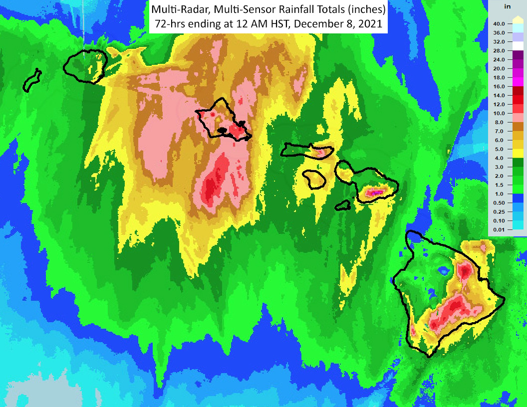
The following are selected rainfall totals for the 3-day period (72 hours) ending at midnight HST, Wednesday, December 8. All amounts are in inches. These totals are considered preliminary for information purposes only.
Location                         3-day total

Kauai
Omao                               4.78
Kapahi                             4.68
Lihue Airport                      3.83

Oahu
St. Stephens Seminary             12.83
Maunawili                         12.61
Nuuanu Upper                      12.45
Luluku                            11.94
Manoa Lyon Arboretum              11.89
Waihee Pump                       11.36
Moanalua                          11.22
Makua Range                       10.95
Ahuimanu Loop                     10.86
Dillingham                        10.12
Ewa Beach                          9.57
Palisades                          9.44
Aloha Tower                        9.38
Honolulu Airport                   9.28
Waianae                            8.56

Maui County
Kula 1                            12.89
Puu Alii (Molokai)                 9.28
Puu Kukui                          7.25
Ulupalakua                         6.98
Lanai 1                            6.55
Kepuni                             5.73
Lahainaluna                        5.51
Kula Branch Station                4.58
Kahului Airport                    3.48

Big Island
Nene Cabin                        14.26
Keaumo                            13.42
Pali 2                            11.64
Kulani NWR                        11.15
Hilo Airport                       5.77
Note that credible rainfall estimates from the Multi-Radar, Multi- Sensor (MRMS) system showed more than 20 inches of rainfall on Maui along the south-facing slope of Halekala over the Kahikinui Forest Reserve.
Strongest wind gusts from Sunday 12/4 to Monday 12/5:

Location                     Speed     Time/Date

...Kauai...
Lihue Airport                29 MPH    0653 PM 12/05

...Oahu...
Kuaokala                     58 MPH    0236 AM 12/06
Makapu'u Beach               50 MPH    0234 AM 12/06
Honolulu Harbor Pier 1       49 MPH    1105 PM 12/05
Makua Range                  45 MPH    1258 AM 12/06
Palehua                      42 MPH    1136 PM 12/05
Kalaeloa Airport             41 MPH    1132 PM 12/05
Kailua                       40 MPH    0336 AM 12/06
Schofield Barracks           40 MPH    0157 PM 12/06
Honolulu Airport             38 MPH    1113 PM 12/05
Kaneohe Mcas                 38 MPH    0339 AM 12/06
Schofield East               38 MPH    0258 AM 12/06
Dillingham                   37 MPH    0349 AM 12/06
Oahu Forest NWR (USFWS)      36 MPH    1136 PM 12/05
Laniakea                     35 MPH    0305 AM 12/06
Kahuku Training Area         33 MPH    0159 AM 12/06
Pearl City                   33 MPH    1117 PM 12/05
Wheeler Air Force Base       33 MPH    0142 PM 12/06
Laie                         32 MPH    0137 AM 12/06
Mokuleia                     32 MPH    1127 AM 12/06
Waianae Valley               32 MPH    0237 AM 12/06
Punalu'u                     29 MPH    1050 AM 12/06

...Maui County...
Kula 1                       64 MPH    0648 PM 12/05
Kanaha WF                    55 MPH    0957 PM 12/05
Kaneloa                      55 MPH    1054 PM 12/05
Lanai 1                      52 MPH    0837 PM 12/05
Kahului Airport              51 MPH    0956 PM 12/05
AH6GR Maui                   47 MPH    1045 PM 12/05
Lanai Airport                47 MPH    0748 PM 12/05
Molokai Airport              43 MPH    1126 PM 12/05
Kealia Pond (USFWS)          42 MPH    1020 PM 12/05
Puu Alii                     32 MPH    0922 PM 12/05

...Big Island...
Kailua Kona Airport          53 MPH    0753 PM 12/05
Kahuku Ranch                 50 MPH    0529 PM 12/05
Pali 2                       48 MPH    0601 PM 12/05
Kaupulehu                    45 MPH    0936 PM 12/05
Mauna Loa                    45 MPH    0534 PM 12/05
PTA West                     45 MPH    0956 PM 12/05
Kaloko-Honokohau             41 MPH    0415 PM 12/05
PTA Range 17                 41 MPH    0549 PM 12/06
Puho CS                      39 MPH    0322 PM 12/05
Puuanahulu                   39 MPH    0837 PM 12/05
Puuwaawaa                    39 MPH    0937 PM 12/05
Nene Cabin                   38 MPH    0823 PM 12/05
PTA East                     38 MPH    0859 PM 12/06
Pahoa                        35 MPH    1031 AM 12/05
Hilo                         31 MPH    0309 PM 12/05
Hilo Airport                 30 MPH    1233 PM 12/05
Waikoloa                     29 MPH    0835 PM 12/05
Hilo (NOS-NWLON)             27 MPH    0300 PM 12/05
Lower Kahuku                 27 MPH    0623 PM 12/05
Kapapala RAWS                26 MPH    0348 PM 12/05

...Maritime Stations...
Kihei                        68 MPH    0832 PM 12/05
Molokini Light               55 MPH    0934 PM 12/05
Kealakomo                    34 MPH    0144 PM 12/05
Kawaihae (NOS-NWLON)         33 MPH    0924 PM 12/05
Honolulu, HI (NOS-NWLON)     28 MPH    0230 AM 12/06
Observations are collected from a variety of sources with varying equipment and exposures. We thank all volunteer weather observers for their dedication. Not all data listed are considered official.

