
The atmospheric river over the Pacific Northwest will begin to subside today, but lingering rainfall will exacerbate ongoing catastrophic major river flooding, and landslides will continue across portions of western Washington and northwest Oregon for several days. Arctic air will plummet southward into the Northern Plains today, bringing cold air in the single digits to the region by Friday. Read More >
2008 Significant Storm Surveys in WFO Huntsville's County Warning Area (CWA) |
||
|---|---|---|
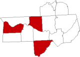
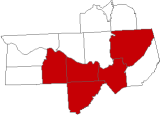
| Primary Areas Affected (Click on map for more information) |
Date of Event | Type of Event |
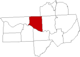 |
December 24, 2008 |
Isolated Tornado |
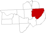 |
December 10, 2008 |
Isolated Tornado |
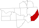 |
May 20, 2008 |
Isolated Tornadoes and Damaging Wind |
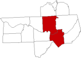 |
April 11, 2008 |
Isolated Tornadoes |
 |
April 4, 2008 |
Isolated Tornadoes and Damaging Wind |
 |
February 6, 2008 |
Tornadoes |


 Local Radar
 Weather Map