
A heat wave over the Southwest will intensify this week, peaking and expanding into the Intermountain West and northern High Plains this weekend. Severe thunderstorms and heavy rainfall are expected over parts of the Upper Midwest to mid-Mississippi Valley today. Critical to extremely critical fire weather conditions from the Northwest and the northern Great Basin on Saturday and Sunday. Read More >
|
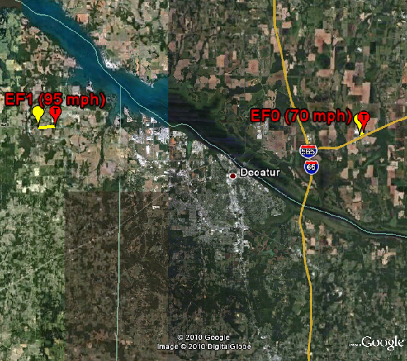
Early Afternoon Activity Around noon on October 26th, 2010, widely scattered severe thunderstorms developed in Franklin county and just west of Lauderdale county in northern Alabama. Both storms became particularly well organized and exhibited supercell characteristics with consistent low to mid level rotation. The storm northwest of Lauderdale County luckily pushed just north of the forecast area. However, the other storm continued to push into northwestern Alabama. Despite numerous reports of a persistent, large wall cloud with this storm, it did not intially produce a confirmed tornado until it pushed into eastern Lawrence County around 1:23 PM. It was rated a a weak EF0 tornado with maximum wind speeds of 70 mph. After 1:30 PM, the coverage of severe thunderstorms increased into the late afternoon hours ahead of a strong cold front. Many of these storms were also mini-supercells with consistent low to mid level rotation. One of these storms produced another brief tornado touchdown in southeastern Limestone county in the Greenbrier community. This severe storm continued northeast into Madison County where it produced straight line wind damage in the Green's Cove and Hobb Island communities. |
|
Confirmed Tornado Paths so far... |
|
Tracks in Northeastern Lawrence county and Southeastern Limestone counties in northern Alabama (click on the track for detailed information on each tornado). |
|
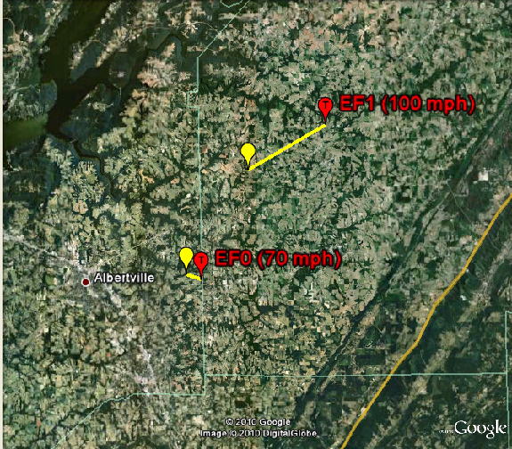
Later in the Afternoon into the Evening Hours. As these severe storms pushed east into northeastern Alabama after 2 PM, most storms continued to display supercell characteristics. Again, numerous reports were received of wall clouds associated with these storms. Two of these supercells produced additional tornadoes. These were the longest and strongest tornadoes that occurred during this event. One of these storms produced the strongest tornado during this event in and near the Geraldine community. This tornado was an EF1 with maximum wind speeds of 100 mph. The second tornado occurred in eastern Marshall County and affected the Albertville and McVille communities. It was rated an EF-0 with maximum wind speeds of 70 mph. By the early evening hours, this activity pushed east of the area into Georgia. |
 |
 |
 |
 |
 |


 Local Radar
 Weather Map