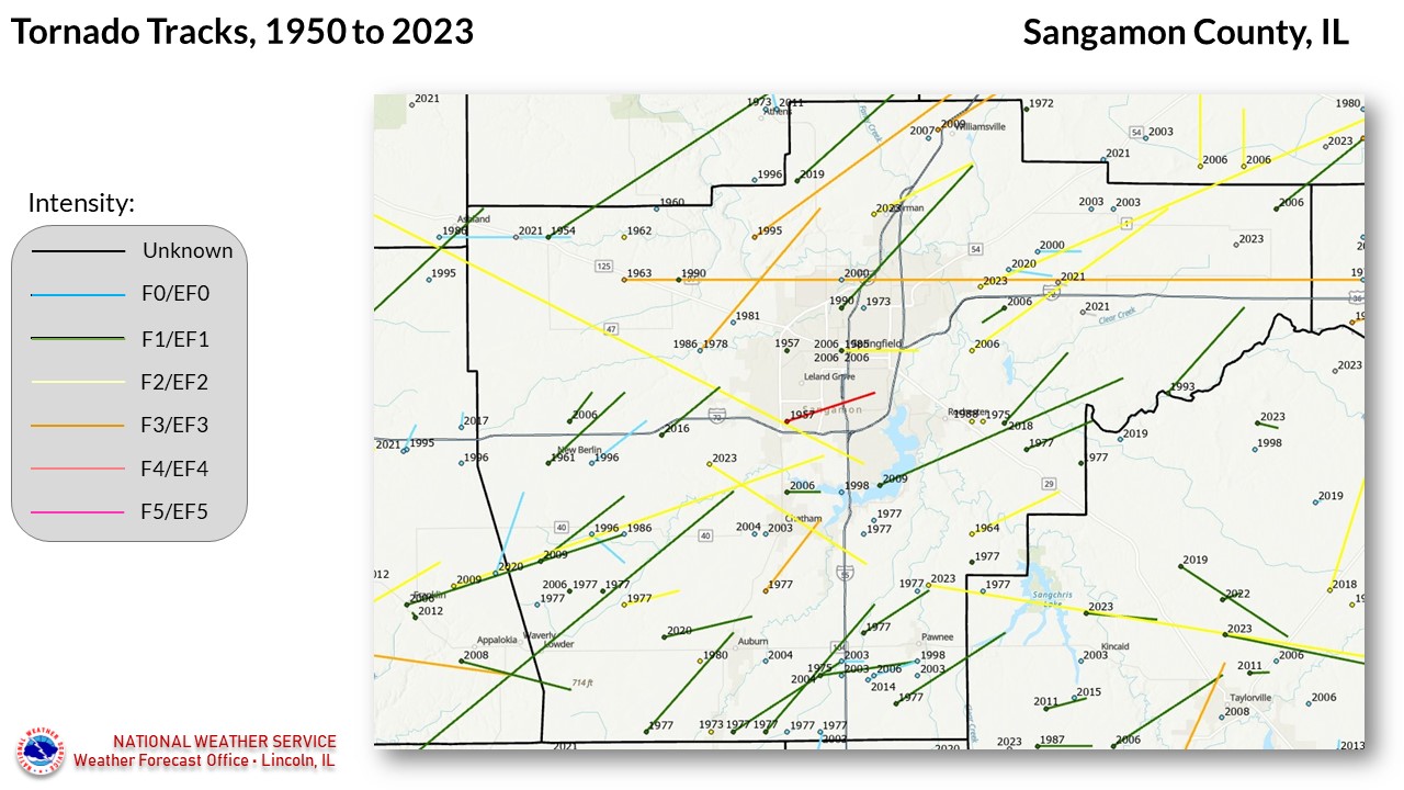
National Weather Service United States Department of Commerce


Sangamon County tornadoes since 1950


87 TORNADOES were reported in Sangamon County, Illinois between 01/01/1950 and 12/31/2022.

Click on Location or County to display Details.

Mag:
Dth:
Inj:
PrD:
CrD:
Magnitude
Deaths
Injuries
Property Damage
Crop Damage
 
Location or County Date Time (CST) Mag Dth Inj PrD CrD
Pleasant Plains 03/12/1954 06:00 PM F1 0 0 250K 0
Riverton 05/13/1957 11:00 AM F1 0 0 0K 0
Springfield 06/14/1957 02:00 PM F4 2 50 2.5M 0
4 Springfield 05/06/1960 01:25 PM F1 0 0 N/A N/A
Springfield 06/23/1960 02:50 PM F2 0 0 250K 0
New Berlin 05/14/1961 10:10 PM F1 0 0 250K 0
Salisbury 05/26/1962 05:30 AM F2 0 0 3K 0
Illiopolis 04/22/1963 05:30 PM F3 1 5 250K 0
New City 04/02/1964 06:45 PM F2 0 0 25K 0
10 Williamsville 06/16/1973 09:58 PM F0 0 0 0K 0
11 Rochester 08/14/1975 05:58 PM F2 0 0 25K 0
12 Divernon 11/29/1975 11:20 PM F1 0 1 250K 0
13 Divernon 08/06/1977 03:25 PM F1 0 0 0K 0
14 Waverly 08/06/1977 03:30 PM F0 0 0 0K 0
15 Lowder 08/06/1977 03:30 PM F1 0 0 0K 0
16 Loami 08/06/1977 03:35 PM F0 0 0 0K 0
17 Divernon 08/06/1977 03:35 PM F0 0 0 0K 0
18 Loami 08/06/1977 03:36 PM F1 0 0 0K 0
19 Loami 08/06/1977 03:36 PM F2 0 0 0K 0
20 Divernon 08/06/1977 03:37 PM F1 0 0 0K 0
21 Thayer 08/06/1977 03:38 PM F1 0 0 25K 0
22 Pawnee 08/06/1977 03:45 PM F1 0 0 0K 0
23 Chatham 08/06/1977 03:45 PM F3 0 0 2.5M 0
24 Pawnee 08/06/1977 03:47 PM F1 0 0 0K 0
25 Chatham 08/06/1977 03:50 PM F0 0 0 0K 0
26 Chatham 08/06/1977 03:51 PM F0 0 0 0K 0
27 Pawnee 08/06/1977 03:53 PM F0 0 0 0K 0
28 New City 08/06/1977 03:57 PM F1 0 0 250K 0
29 Rochester 08/06/1977 04:10 PM F1 0 0 0K 0
30 Springfield 07/26/1978 03:30 PM F1  0 0 250K 0
31 Auburn 07/10/1980 05:00 AM F2 0 0 250K 0
32 Bradfordton 06/08/1981 08:40 PM F0 0 0 0K 0
33 Springfield 07/14/1985 11:44 PM F0 0 0 25K 0
34 Springfield 05/16/1986 04:20 PM F0 0 0 0K 0
35 Loami 05/16/1986 04:25 PM F0 0 0 0K 0
36 Pleasant Plains 06/04/1986 03:22 PM F0 0 0 0 N/A
37 Rochester 05/08/1988 05:18 PM F2 0 0 250K 0
38 Bradfordton 06/20/1990 12:15 AM F1 0 0 25K 0
39 Illiopolis 06/08/1993 04:30 PM F1 0 0 N/A N/A
40 Cantrall 05/09/1995 04:22 PM F3 0 6 1.0M 0
41 New Berlin 04/19/1996 05:32 PM F0 0 0 250K 0
42 Loami 05/27/1996 09:45 PM F0 0 0 0 0
43 Springfield 06/29/1998 04:30 PM F0 0 0 0 0
44 Pawnee 06/29/1998 04:36 PM F0 0 0 130K 0
45 Pleasant Plains 04/08/1999 07:53 PM F0 0 0 0 0
46 Illiopolis 04/20/2000 08:05 AM F0 0 0 0 0
47 Dawson 05/12/2000 03:30 PM F0 0 0 0 0
48 Springfield Airport 06/20/2000 06:44 PM F0 0 0 1K 0
49 Pawnee 03/19/2003 01:25 PM F0 0 0 0 0
50 Chatham 05/09/2003 06:40 PM F0 0 0 0 0
51 Divernon 05/10/2003 06:53 AM F0 0 0 0 0
52 Divernon 05/10/2003 06:55 AM F0 0 0 0 0
53 Auburn 05/10/2003 06:58 AM F0 0 0 45K 0
54 Buffalo 06/11/2003 05:20 PM F0 0 0 0 0
55 Illiopolis 06/11/2003 05:22 PM F0 0 0 0 0
56 Auburn 05/23/2004 06:27 PM F0 0 0 0 0
57 Divernon 05/24/2004 11:09 PM F1 0 0 0 0
58 Chatham 08/26/2004 05:09 PM F0 0 0 0 0
59 Loami 03/12/2006 08:00 PM F1 0 0 0 0
60 New Berlin 03/12/2006 08:02 PM F2 0 19 N/A  0
61 Springfield 03/12/2006 08:24 PM F2 0 0 N/A  0
62 Riverton 03/12/2006 08:32 PM F2 0 4 N/A  0
63 Loami 04/02/2006 04:46 PM F1 0 0 0 0
64 Berlin 04/02/2006 04:49 PM F1 0 0 0 0
65 Chatham 04/02/2006 04:56 PM F1 0 0 0 0
66 Springfield 04/02/2006 04:58 PM F1 0 0 0 0
67 Pawnee 04/02/2006 04:59 PM F0 0 0 0 0
68 Springfield 04/02/2006 05:06 PM F1 0 0 N/A  0
69 Riverton 04/02/2006 05:13 PM F1 0 1 N/A  0
70 Williamsville 09/06/2007 05:28 PM EF0 0 0 0 0
71 Lowder 05/30/2008 06:23 PM EF1 0 0 63K 0
72 Loami 03/08/2009 10:32 AM EF1 0 2 610K 0
73 Loami 08/19/2009 01:51 PM EF2 0 3 4.0M 330K
74 Lake Springfield 08/19/2009 02:17 PM EF1 0 0 200K 240K
75 Williamsville 08/19/2009 02:19 PM EF3 0 17 11.0M 75K
76 Divernon 02/20/2014 03:43 PM EF0 0 0 30K 0
77 Mechanicsburg 02/20/2014 03:57 PM EF1 0 0 990K 0
78 Curran 03/15/2016 06:44 PM EF1 0 0 280K 0
79 Rochester 12/01/2018 06:16 PM EF1 0 0 225K 0
80 Cantrall 05/22/2019 11:15 PM EF1 0 0 0 0
81 Dawson 04/28/2020 05:56 PM EF0 0 0 100K 0
82 New Berlin 07/15/2020 03:30 PM EF0 0 0 10K 50K
83 Divernon 07/15/2020 04:25 PM EF0 0 0 0 5K
84 Auburn 07/21/2020 03:05 PM EF1 0 0 300K 50K
85 Pleasant Plains 05/03/2021 04:27 PM EFU 0 0 0 0
86 Dawson 05/03/2021 05:10 PM EFU 0 0 0 0
87 Mechanicsburg 05/03/2021 05:14 PM EFU 0 0 0 0
TOTALS: 3 102 25.64M 750K


Details:

  1. 3/12/1954:  Touched down near Pleasant Plains, and moved northeast to near Lincoln.
  2. 5/13/1957:  Touched down at Camp Butler National Cemetery.
  3. 6/14/1957:  This tornado moved across the southeast side of Springfield and through Jerome, very close to the track of the March 12, 2006 tornado.  Two people were killed, and 50 were injured.  The parent thunderstorm produced a 98 mph wind gust at Capital Airport on the north side of town.
  4. 5/6/1960:  Originally touched down near Carrollton in Greene County, and moved northeast making intermittent contact with the ground to near Springfield.
  5. 6/23/1960:  This tornado originated near Virginia (Cass County), and moved southeast into Sangamon County.  It took an intermittent path, finally lifting 7 miles south of downtown Springfield.
  6. 5/14/1961: This tornado touched down near New Berlin, and lifted 8 miles south of Pleasant Plains.  One home and several other buildings were destroyed, with numerous other buildings damaged.
  7. 5/26/1962:  Brief touchdown 2 miles west of Salisbury, damaging a house roof and farm buildings.
  8. 4/22/1963:  This strong tornado touched down near the west edge of Illiopolis, and moved east into Macon County.  The east side of Illiopolis received the most severe damage, where several homes and businesses were destroyed.  Farm homes were demolished east of town.
  9. 4/2/1964:  Touched down about 3 miles west of Sangchris Lake State Park, and moved northeast to about highway 29.
  10. 6/16/1973:  Brief touchdown between Athens and Williamsville.
  11. 8/14/1975:  Touched down just east of Rochester, destroying 3 storage bins on a farm, and damaging a house.
  12. 11/29/1975:  Traveled 4 miles from Divernon to near Pawnee.  Four trailers in Pawnee were damaged or destroyed.
  13. 8/6/1977:  Seventeen tornadoes occurred across Sangamon County on this date.   This particular tornado touched down 2 miles southeast of Thayer, and moved northeast across Divernon, causing minor damage.
  14. 8/6/1977:  Touched down 3 miles north-northeast of Waverly, and was on the ground for 3/4 mile, but caused no damage.
  15. 8/6/1977:  Touched down 1 mile southwest of Lowder and moved over 7 miles to near Auburn, primarily remaining in rural areas.
  16. 8/6/1977:  Touched down 3 miles south-southwest of Loami, and moved through open fields for about 1.3 miles.
  17. 8/6/1977:  Two tornadoes touched down 2 miles southwest of Divernon; this was the southern one, on the ground for 2 miles.
  18. 8/6/1977:   Was on the ground for 1.3 miles, touching down 3 miles south-southwest of Loami.
  19. 8/6/1977:  This tornado developed over the south fork of Lick Creek, 3 miles south-southeast of Loami, mainly passing through fields, but destroying buildings on two farms.
  20. 8/6/1977:  Two tornadoes touched down 2 miles southwest of Divernon; this was the northern one, on the ground for 1 mile (see #16 for the other one).
  21. 8/6/1977:  Touched down in Thayer, then moved northeast for nearly 7 miles.
  22. 8/6/1977:  This tornado touched down 2.5 miles southwest of Pawnee, then moved northeast into Christian County.  It mainly occurred in open fields.
  23. 8/6/1977:  This was the strongest of the tornadoes in the county on this date.  It touched down 2 miles east-southeast of Chatham, and moved northeast to the edge of Lake Springfield.  The Glenwood Park subdivision was hit hard.  About 40 homes were destroyed or severely damaged.
  24. 8/6/1977:  Touched down just east of Pawnee Junction (I-55/IL-104 interchange), and moved northeast for about 5 miles.  One farm was extensively damaged.
  25. 8/6/1977:  Touched down about 3 miles east of Chatham, and was on the ground for about 1/2 mile, remaining over open fields.
  26. 8/6/1977:  Touched down about 2.5 miles east of Chatham, and remained in open fields.
  27. 8/6/1977:  Touched down 2 miles north of Pawnee.  Surveys of the swirl patterns in the cornfields indicated that this tornado had a clockwise circulation (instead of the usual counter-clockwise).
  28. 8/6/1977:  Touched down 5 miles north-northeast of Pawnee, damaging several farms buildings.  It moved northeast for a little over 2 miles.
  29. 8/6/1977:  Touched down about 2 mile east of Rochester, and was on the ground for 4 miles.  Heavy damage occurred to a farm.
  30. 7/26/1978:  This tornado touched down on the west side of Springfield, and moved north-northeast for about 9 miles to near Cantrall.  The worst of the damage occurred near Cantrall, where a home was severely damaged.
  31. 7/10/1980:  Touched down 2 miles west of Auburn, and moved 1-1/2 miles northeast.  Eight to 10 grain bins were destroyed.
  32. 6/8/1981:  Brief touchdown near Bradfordton.  The thunderstorm had been producing intermittent tornado touchdowns as far back as near Macomb.
  33. 7/14/1985:  Brief touchdown on the southeast side of Springfield.
  34. 5/16/1986: Brief touchdown 6 miles west of Springfield.
  35. 5/16/1986: Brief touchdown near Loami.
  36. 6/4/1986:  Originally touched down near Ashland, and moved 3 miles eastward into Sangamon County.
  37. 5/8/1988:  Touched down near Lake Springfield, off East Lake Shore Dr.  One house was destroyed, and 3 others under construction were blown over.
  38. 6/2/1990:  Touched down near the junction of highways 97 and 125.
  39. 6/8/1993:  Touched down several times along a path southeast of Mechanicsburg and southwest of Illiopolis.  It damaged part of a school, destroyed 5 storage facilities, 4 homes and an apartment building, and damaged 63 other homes.
  40. 5/9/1995:  This tornado touched down 3 miles east of Salisbury, and moved northeast across northern Sangamon County.  The worst damage in the county was in Cantrall, where 3 homes were destroyed, 10 suffered major damage, and the grade school was extensively damaged.  The tornado continued on and clipped extreme southeast Menard County before continuing into Logan County; total path length of the tornado was 40 miles.    Damage estimates in Sangamon County were $1 million.
  41. 4/19/1996:  This tornado touched down 2 miles east of New Berlin, lifted and touched down again 5 miles east-northeast of New Berlin.  Major damage occurred to a home, barn, and machine shed.
  42. 5/27/1996:  This tornado initially touched down in an open field 2 miles west of Loami, then lifted before touching down again 1 mile south of Loami.
  43. 6/29/1998:  Brief touchdown 7 miles south of Springfield, in the Huntington Heights subdivision.  More significant damage across the county was reported due to the associated derecho (windstorm), which originated in Iowa during the afternoon and had reached southern Ohio by the next morning.
  44. 6/29/1998:  Touched down on the north side of Pawnee, and was on the ground for 1 mile, blowing the roof off a house.
  45. 4/8/1999:  This tornado first touched down in northeast Morgan County, then clipped extreme southeast Cass County (going through Ashland) before entering Sangamon County 4 miles northwest of Pleasant Plains and dissipating.  No damage was reported in Sangamon County.
  46. 4/20/2000:  Brief touchdown 1 mile south of Illiopolis, causing minor damage.
  47. 5/12/2000:  Touched down 1 mile south of Dawson, and made a series of touchdowns before dissipating 2 miles northwest of Buffalo.
  48. 6/20/2000:  Brief touchdown 2 miles east-northeast of Springfield's Capital Airport, destroying several large trees and damaging 4 homes.
  49. 3/19/2003:  Brief touchdown in a field 1 mile south of Pawnee.
  50. 5/9/2003:  Brief touchdown 1 mile west of Chatham, blowing down several trees and damaging a few homes.
  51. 5/10/2003:  Brief touchdown in a field 2 miles south of Divernon.
  52. 5/10/2003:  Brief touchdown 1 mile east of Dawson, destroying a barn.
  53. 5/10/2003:  Touched down 5 miles east of Auburn, near I-55 and state route 104; damaged several businesses and destroyed a couple of sheds.
  54. 6/11/2003:  Brief touchdown in a field 4 miles north of Buffalo.
  55. 6/11/2003:  Brief touchdown in a field 3 miles north of Illiopolis.
  56. 5/23/2004:  Brief touchdown near the golf course 2 miles east of Auburn.
  57. 5/24/2004:  Brief touchdown in Divernon, destroying 5 garages and blowing down numerous trees.  Several homes sustained some damage.
  58. 8/26/2004:  Brief touchdown in a field 2 miles west of Chatham.
  59. 3/12/2006:  This tornado moved in from Morgan County, and was on the ground for 12 miles.  Click here for details.
  60. 3/12/2006:  This is a continuation of a long-track tornado, which ended up traveling 66 miles before lifting in Springfield.  Click here for details.
  61. 3/12/2006:  This is the second of two strong tornadoes to affect Springfield on this date.  Click here for details.
  62. 3/12/2006:  This tornado touched down south of Riverton, and moved northeast into Logan county.  Click here for details.
  63. 4/2/2006:  One of 7 tornadoes to occur in Sangamon County on this date.  This tornado touched down 4 miles southwest of Loami.
  64. 4/2/2006:  Touched down just north of Berlin.
  65. 4/2/2006:  Touched down 2 miles north of Chatham.
  66. 4/2/2006:  Touched down on the southwest side of Springfield.
  67. 4/2/2006:  Touched down 2 miles southwest of Pawnee.
  68. 4/2/2006:  Touched down on the southeast side of Springfield.
  69. 4/2/2006:  Touched down on the south side of Riverton.
  70. 9/6/2007:  Brief touchdown 1 mile west of Williamsville.
  71. 5/30/2008:  Moved in from Morgan County, 4 miles west-northwest of Lowder, and was on the ground for 1 mile in Sangamon County.  Destroyed a garage and pole barn, and damaged another pole barn, house, and several trees.
  72. 3/8/2009:  Touched down 6 miles southwest of Loami, and moved northeast to near Loami.
  73. 8/19/2009:  This tornado moved in from Morgan County, and traveled 16 miles across Sangamon County, crossing through Loami before lifting near Chatham.
  74. 8/19/2009:  This tornado touched down in extreme southeast Springfield, near the west side of Lake Springfield, moving northeast past Rochester to near Mechanicsburg, for a total path of 13 miles.  Mostly tree and crop damage was observed, although a few structures were damaged by falling limbs.
  75. 8/19/2009:  This EF-3 tornado touched down at Williamsville and moved northeast into Logan County.
  76. 2/20/2014:  Brief touchdown 1.7 miles east of Divernon, tearing the roof off a barn.
  77. 2/20/2014:  Touched down just north of the Sangamon/Christian County border, passing east of Mechanicsburg before crossing I-72 just west of Illiopolis.  Click here for more details.
  78. 3/15/2016:  This tornado touched down 2.4 miles west of Curran, and tracked to the far western edge of Springfield. Click here for more details. 
  79. 12/1/2018:  This tornado was part of a historic late-season tornado outbreak in central Illinois. It touched down 1.5 miles east of Rochester, and was on the ground for 4.7 miles. Click here for more details 
  80. 5/22/2019:  Touched down 1.6 miles southwest of Cantrall, moving northeast and clipping far southeast Menard County. Click here for more details. 
  81. 4/28/2020:  Touched down 1.8 miles west-northwest of Dawson, damaging 12 buildings.
  82. 7/15/2020:  This tornado moved in from Morgan County and dissipated 2.5 miles southwest of New Berlin. Minor crop and tree damage occurred in Sangamon County.
  83. 7/15/2020:  This tornado moved in from Montgomery County, impacting far southern Sangamon County south of Divernon. About 15 acres of a corn field were damaged.
  84. 7/21/2020:  Touched down 2.7 miles west-northwest of Auburn, destroying 2 large sheds and 2 grain bins. Several trees were also damaged, as well as 100 acres of corn and soybeans.
  85. 5/23/2021:  Weak tornado touched down 1.4 miles west-northwest of Pleasant Plains, causing no damage.
  86. 5/23/2021:  Weak tornado touched down about a mile southeast of Dawson, causing no damage.
  87. 5/23/2021:  Weak tornado touched down 2 miles northwest of Mechanicsburg, causing no damage.