Overview
From the morning hours of Wednesday February 2nd through the morning hours on Friday February 4th, a strong winter system moved through central Indiana initially bringing heavy rain to the area which then transitioned to a mix of sleet and freezing rain before becoming all snow. Snow began across the Lafayette area Wednesday morning with the heaviest snow during the day. The transition line spread to a line roughly from Muncie to Terre Haute before slowing down significantly. Heavy snow then impacted the I-70 corridor and points south on Thursday with additional light snow through the morning hours Friday. Significant travel impacts were noted throughout the storm with at least 15 of 39 central Indiana categories reaching their most severe form of county status, Travel Warning.
Snow
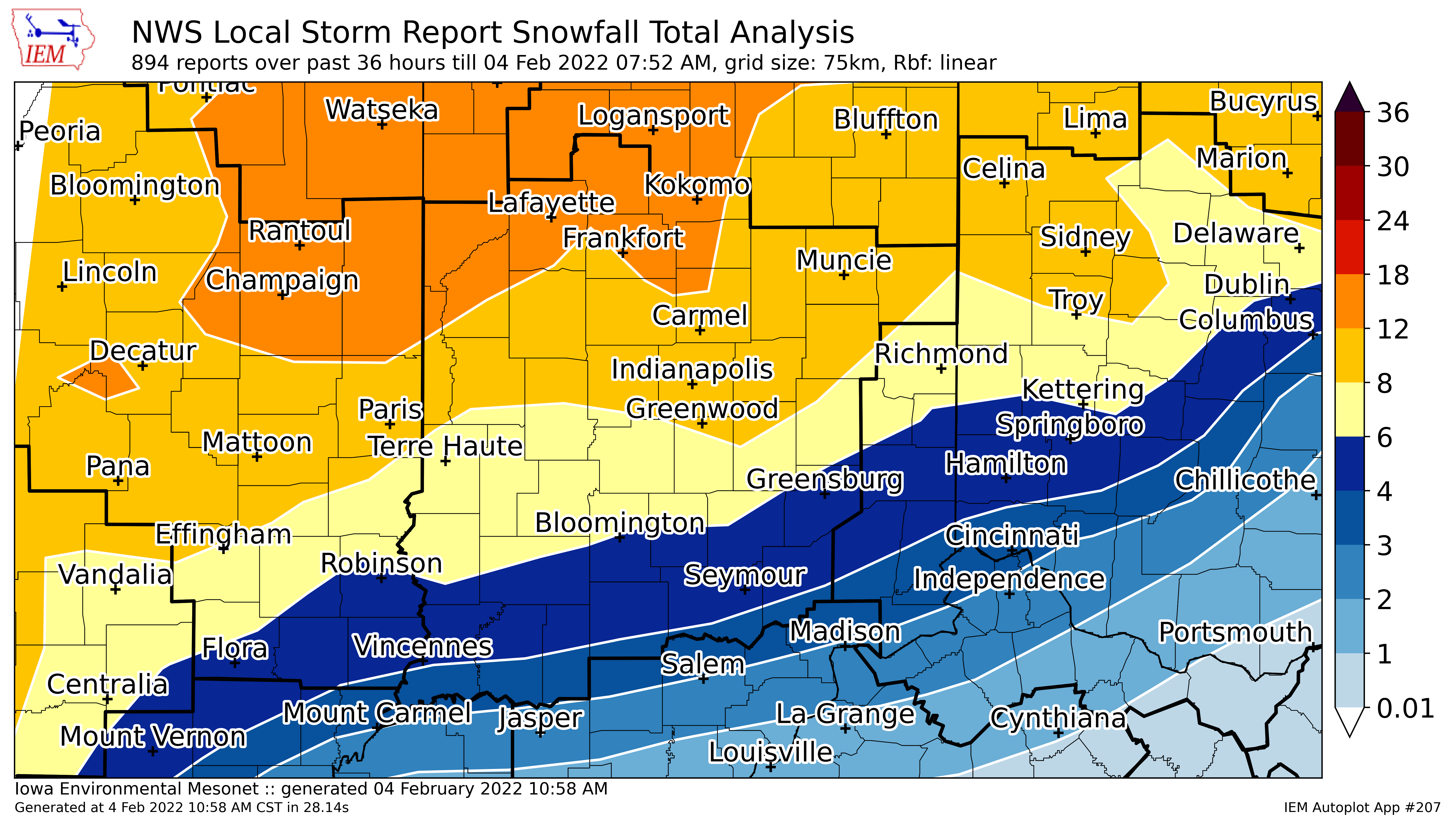
...2-DAY SNOWFALL REPORTS...7 AM 2/2 to 7 AM 2/4/2022...

Note: Values from Tippecanoe and Warren Counties are 3-DAY
SNOWFALL REPORTS...7 AM 2/1 to 7 AM 2/4/2022


I. GREATEST REPORTS for each COUNTY, where 8.0 or greater...

 County       Location              Snowfall  Source

 CARROLL      Camden                 15.5 in  Public
 TIPTON       Tipton 5 SW            13.6 in  CoCoRaHS
 FOUNTAIN     Veedersburg            13.5 in  Public
 TIPPECANOE   West Lafayette 1 NW    13.2 in  Broadcast Media
 HOWARD       Kokomo                 12.8 in  Broadcast Media
 MONTGOMERY   Waynetown              12.5 in  Public
 CLINTON      Frankfort              12.0 in  Public
 WARREN       State Line City 1 ENE  11.8 in  Public
 DELAWARE     Ball State University  10.5 in  Public
 HANCOCK      New Palestine 1.2 NW   10.0 in  CoCoRaHS
 RUSH         Morristown 3.8 ENE     10.0 in  CoCoRaHS
 MARION       Indianapolis Downtown   9.9 in  Public
 HENRY        Lewisville 1 W          9.8 in  Public
 RANDOLPH     Modoc                   9.5 in  CoCoRaHS
 MADISON      North Anderson          8.8 in  Public
 HENDRICKS    Avon 1.6 NNW            8.7 in  CoCoRaHS
 JOHNSON      Greenwood 2.6 W         8.7 in  CoCoRaHS
 HAMILTON     Mccordsville 2.6 NE     8.6 in  CoCoRaHS
 SULLIVAN     Farmersburg TV-2        8.3 in  COOP
 PARKE        Rockville 3.6 ENE       8.0 in  CoCoRaHS


II. STORM TOTAL FROZEN PRECIPITATION REPORTS, by county...

Central Indiana location     Amount   Time/Date   Provider

...Bartholomew County...
Taylorsville 0.8 SSW         6.5 in  0430 AM 2/4  CoCoRaHS
Clifford 2 SSE               6.0 in  1049 AM 2/4  Trnd Spotter
Columbus 2.2 NE              5.5 in  0700 AM 2/4  CoCoRaHS
Columbus 6 WSW               5.5 in  0950 AM 2/4  Public
Flat Rock 1.2 SSW            4.6 in  0700 AM 2/4  CoCoRaHS

...Boone County...
Whitestown 3.1 E             8.6 in  0700 AM 2/4  CoCoRaHS
Pike 1.5 ESE                 8.5 in  0700 AM 2/4  CoCoRaHS
Jamestown 2 E                8.0 in  0700 AM 2/4  COOP
Sheridan 2.0 SW              7.5 in  0700 AM 2/4  CoCoRaHS
Lebanon 6 W                  7.2 in  0700 AM 2/4  COOP
Zionsville                   6.7 in  0600 AM 2/4  CoCoRaHS
Thorntown 2 SW               6.5 in  1245 PM 2/3  Trnd Spotter

...Brown County...
Beanblossom 1 NNE            6.3 in  1103 AM 2/4  Public
Needmore 1.7 SSW             4.4 in  1000 AM 2/4  CoCoRaHS
Stone head 2.3 ENE           3.6 in  0700 AM 2/4  CoCoRaHS

...Carroll County...
Camden                      15.5 in  0321 PM 2/4  Trnd Spotter
Delphi 2 E                  15.0 in  0321 PM 2/3  Public
Burlington                  14.5 in  0405 PM 2/3  Public
Flora                       14.5 in  1010 PM 2/3  Public
Burlington                  12.5 in  0700 AM 2/4  CoCoRaHS
Flora                       12.0 in  0700 AM 2/4  COOP
Yeoman 2 WSW                12.0 in  0320 PM 2/3  Public
Burrows 2 S                 12.0 in  0400 PM 2/3  Public

...Clay County...
Clay City                    8.4 in  0700 AM 2/4  CoCoRaHS
Brazil 1 E                   6.2 in  1056 AM 2/4  Public
Howesville                   5.2 in  0908 AM 2/4  CoCoRaHS
Bowling Green 1 W            5.0 in  0700 AM 2/4  COOP

...Clinton County...
Frankfort                   12.0 in  1114 AM 2/4  Public
Mulberry 0.6 SSE            12.0 in  0800 AM 2/4  CoCoRaHS
Kilmore 1.0 ENE             11.6 in  0700 AM 2/4  CoCoRaHS
Frankfort Disposal          11.0 in  1159 PM 2/3  COOP

...Daviess County...
Elnora                       5.7 in  0400 PM 2/4  COOP
Plainville 1.3 S             5.4 in  0700 AM 2/4  CoCoRaHS
Washington 1 W               4.8 in  0600 PM 2/4  COOP
Washington 3.3 SE            3.9 in  0700 AM 2/4  CoCoRaHS

...Decatur County...
Lake Santee 1 NW             3.0 in  0536 PM 2/3  Public

...Delaware County...
Ball State University       10.5 in  1049 AM 2/4  Public
Muncie 1.2 SE                7.9 in  0755 AM 2/4  CoCoRaHS
Macedonia                    7.8 in  0700 AM 2/4  CoCoRaHS
Yorktown 1.1 NNW             7.3 in  0700 AM 2/4  CoCoRaHS

...Fountain County...
Veedersburg                 13.5 in  0700 PM 2/4  Public
Covington                    7.0 in  0700 AM 2/3  CoCoRaHS

...Greene County...
Elliston-Bloomfield          6.3 in  0800 AM 2/4  COOP
Owensburg 1.0 N              5.0 in  0654 AM 2/4  CoCoRaHS
Bloomfield 5.3 ESE           4.5 in  0830 AM 2/4  CoCoRaHS

...Hamilton County...
McCordsville 2.6 NE          8.6 in  0700 AM 2/4  CoCoRaHS
Carmel 2 NNW                 8.1 in  0847 PM 2/3  Public
Fishers 2 NE                 8.0 in  0950 AM 2/4  Public
Fishers 4.3 ENE              7.5 in  0700 AM 2/4  CoCoRaHS
Sherridan 2.0 SW             7.5 in  0700 AM 2/4  CoCoRaHS
Carmel 1.4 NNE               7.2 in  0700 AM 2/4  CoCoRaHS
Carmel 2.8 NE                6.5 in  0700 AM 2/4  CoCoRaHS
Westfield 2 SE               6.0 in  0830 PM 2/3  Public
Noblesville 1 SE             5.0 in  0237 PM 2/3  Public
Strawtown 2.2 E              5.0 in  0700 AM 2/4  CoCoRaHS

...Hancock County...
New Palestine 1.2 NW        10.0 in  0800 AM 2/4  CoCoRaHS
Greenfield                   9.4 in  0900 AM 2/4  Public
Greenfield 5 W               8.9 in  0800 AM 2/4  Public
New Palestine 1.4 S          8.0 in  0700 AM 2/4  CoCoRaHS
Wilkinson 4.1 W              6.5 in  0700 AM 2/4  CoCoRaHS
Mccordsville 4 SSE           5.0 in  0215 PM 2/3  Public

...Hendricks County...
Avon 1.6 NNW                 8.7 in  0700 AM 2/4  CoCoRaHS
Avon 1.4 SSW                 7.6 in  0700 AM 2/4  CoCoRaHS
Brownsburg 5.1 NNE           7.5 in  0700 AM 2/4  CoCoRaHS
Plainfield                   7.5 in  0700 AM 2/4  Public
Brownsburg 0.8 NNW           7.3 in  0700 AM 2/4  CoCoRaHS
Eagle Creek Reservoir 5 NNW  7.1 in  0804 PM 2/3  Amtr Radio
Brownsburg 2 SSE             7.0 in  0638 PM 2/3  Trnd Spotter

...Henry County...
Lewisville 1 W               9.8 in  0953 AM 2/4  Public
New Castle 3.2 W             8.2 in  0700 AM 2/4  CoCoRaHS
New Castle 3 SW              8.0 in  0700 AM 2/4  COOP
Straughn 2 NW                6.5 in  0342 PM 2/3  Amtr Radio
Knightstown                  6.3 in  1001 AM 2/4  Public

...Howard County...
Kokomo                      12.8 in  1016 AM 2/4  Brdcst Media
Kokomo 3 WSW                11.0 in  0700 AM 2/4  CoCoRaHS
Indian Heights 1 WNW        11.0 in  0100 PM 2/3  Public
Kokomo 1 NNW                10.0 in  0950 AM 2/4  Public

...Jackson County...
Brownstown 2 ENE             4.8 in  1057 AM 2/4  Emrgncy Mngr
Seymour                      2.4 in  0700 AM 2/4  CoCoRaHS

...Jennings County...
North Vernon                 4.3 in  0954 AM 2/4  Public

...Johnson County...
Greenwood 2.6 W              8.7 in  0700 AM 2/4  CoCoRaHS
Waverly 4 ENE                8.5 in  0648 PM 2/3  Public
Franklin                     8.2 in  0700 AM 2/4  Public
New Whiteland                8.0 in  0824 PM 2/3  Public
Franklin WWTP                7.9 in  0700 AM 2/4  COOP
Greenwood 4.6 SW             7.1 in  0700 AM 2/4  CoCoRaHS
Franklin 1 W                 6.3 in  0700 AM 2/4  COOP

...Knox County...
Bicknell 0.5 W               4.5 in  0730 AM 2/4  CoCoRaHS
Vincennes 4 E                4.3 in  0700 AM 2/4  COOP

...Lawrence County...
Harrodsburg 2.9 SSW          6.1 in  0945 AM 2/4  CoCoRaHS
Buddha                       4.0 in  0700 AM 2/4  CoCoRaHS
Oolitic 2.8 ENE              3.7 in  0700 AM 2/4  CoCoRaHS
Mitchell 4.1 E               3.5 in  0730 AM 2/4  CoCoRaHS

...Madison County...
North Anderson               8.8 in  0700 AM 2/4  Public
Ingalls 3.0 WNW              8.0 in  0700 AM 2/4  CoCoRaHS
Anderson 4.0 N               7.1 in  0700 AM 2/4  CoCoRaHS
Country Club Heights 2 N     7.1 in  0933 PM 2/3  CoCoRaHS
Elwood                       7.0 in  0400 PM 2/3  Public
Woodlawn Heights 1 S         6.0 in  0231 PM 2/3  Public
Linwood 4 E                  5.7 in  0341 PM 2/3  Amtr Radio
Anderson 2.0 S               5.0 in  0700 AM 2/4  CoCoRaHS

...Marion County...
Indianapolis Downtown        9.9 in  0700 AM 2/4  Public
Irvington                    9.6 in  0700 AM 2/4  CoCoRaHS
Warren Park 1 SW             8.2 in  0725 PM 2/3  Public
Clermont 1.1 N               8.0 in  0700 AM 2/4  CoCoRaHS
Indianapolis 1 ENE           8.0 in  0824 PM 2/3  Public
Southport 5 E                8.0 in  0700 AM 2/4  NWS Emply
Indianapolis Intl Arpt 1 SE  7.6 in  1259 AM 2/4  NWS WFO
McCordsville 1.3 W           7.6 in  0700 AM 2/4  CoCoRaHS
Oaklandon                    7.5 in  1052 AM 2/4  Public
Meridian Hills               7.0 in  0700 AM 2/4  CoCoRaHS
Speedway                     6.9 in  0700 AM 2/4  CoCoRaHS
Williams Creek               6.5 in  0700 AM 2/4  CoCoRaHS

...Martin County...
Shoals 8 S                   2.5 in  0700 AM 2/4  COOP
Shoals 4.0 E                 2.5 in  0700 AM 2/4  CoCoRaHS

...Monroe County...
Ellettsville 2.7 NE          6.5 in  0700 AM 2/4  CoCoRaHS
Ellettsville 1 WNW           6.5 in  0954 AM 2/4  Amtr Radio
Unionville 3.2 NNW           6.0 in  0843 AM 2/4  CoCoRaHS
Stinesville 2 NE             5.8 in  1013 PM 2/3  Public
Ellettsville 0.5 W           5.6 in  0700 AM 2/4  CoCoRaHS
Bloomington 6.5 WNW          5.5 in  0800 AM 2/4  CoCoRaHS
Bloomington 1.7 NNW          4.5 in  0700 AM 2/4  CoCoRaHS

...Montgomery County...
Waynetown                   12.5 in   949 AM 2/4  Public
Crawfordsville 1 S          12.0 in  0953 AM 2/4  Public
Crawfordsville 6 SE         11.6 in  0600 AM 2/4  COOP
New Market 2.6 WNW          10.3 in  0700 AM 2/4  NWS Emply

...Morgan County...
Brooklyn                     7.8 in  0820 AM 2/4  CoCoRaHS
Paragon 3.2 ENE              7.5 in  0700 AM 2/4  CoCoRaHS
Mooresville 1.8 NE           7.4 in  0700 AM 2/4  CoCoRaHS
Camby 1 SSW                  7.0 in  0714 PM 2/3  NWS Emply
Martinsville 2.3 SE          5.4 in  0700 AM 2/4  CoCoRaHS

...Owen County...
Mccormicks Creek State Park  6.2 in  1059 AM 2/4  Public
Stinesville 2 W              5.8 in  0744 PM 2/3  Public
Spencer 3 NW                 5.7 in  1008 AM 2/4  Public
Spencer                      5.5 in  0700 AM 2/4  COOP
Freeman 2.7 WSW              5.0 in  0700 AM 2/4  CoCoRaHS
Freeman 2.8 NNE              4.8 in  0700 AM 2/4  CoCoRaHS

...Parke County...
Rockville 3.6 ENE            8.0 in  0700 AM 2/4  CoCoRaHS

...Putnam County...
Bainbridge                   6.0 in  0253 PM 2/3  Public
Greencastle 1 w              6.0 in  0321 PM 2/3  Trnd Spotter
Cloverdale 3.5 W             5.8 in  0745 AM 2/4  CoCoRaHS

...Randolph County...
Modoc                        9.5 in  0700 AM 2/4  CoCoRaHS
Parker City                  9.0 in  0700 AM 2/4  CoCoRaHS
Winchester 2.2 WSW           8.0 in  0700 AM 2/4  CoCoRaHS

...Rush County...
Morristown 3.8 ENE          10.0 in  0700 AM 2/4  CoCoRaHS
Carthage 1 NNE               6.1 in  1102 AM 2/4  Public
Rushville 0.7 ENE            4.8 in  0607 PM 2/3  Public
Rushville                    3.5 in  0700 AM 2/4  COOP
Homer                        3.0 in  0700 AM 2/4  CoCoRaHS

...Shelby County...
Shelbyville 2 SSW            7.9 in  0629 AM 2/4  Public
Shelbyville                  6.4 in  0700 AM 2/4  CoCoRaHS
Shelbyville 1.6 SSE          6.1 in  0700 AM 2/4  CoCoRaHS

...Sullivan County...
Farmersburg TV-2             8.3 in  1158 PM 2/3  COOP
Graysville 5 WNW             6.6 in  0700 AM 2/4  COOP
Hymera                       5.0 in  0700 AM 2/4  CoCoRaHS

...Tippecanoe County...
West Lafayette 1 NW         13.2 in  0545 PM 2/3  Brdcst Media
Otterbein 2.0 ESE           13.0 in  0700 AM 2/4  CoCoRaHS
West Lafayette 3.3 WNW      12.7 in  0700 AM 2/4  CoCoRaHS
West Lafayette              12.0 in  0100 PM 2/3  Brdcst Media
Battle Ground 4.0 WNW       11.8 in  0700 AM 2/4  CoCoRaHS
Lafayette 8 S               11.7 in  0700 AM 2/4  COOP
Lafayette 2.5 NE            10.4 in  0700 AM 2/4  CoCoRaHS
Lafayette 2.2 S             10.2 in  0700 AM 2/4  CoCoRaHS

...Tipton County...
Tipton 5 SW                 13.6 in  0600 AM 2/4  CoCoRaHS

...Vigo County...
Shepardsville 3.8 SE         7.0 in  0830 AM 2/4  CoCoRaHS
Terre Haute                  6.3 in  0902 PM 2/3  Public
Seelyville 3.2 S             5.0 in  0842 AM 2/4  CoCoRaHS

...Warren County...
State Line City 1 ENE       11.8 in  1101 AM 2/4  Public


Observations are collected from a variety of sources with varying
equipment and exposures. We thank all volunteer weather observers
for their dedication. Not all data listed are considered official.
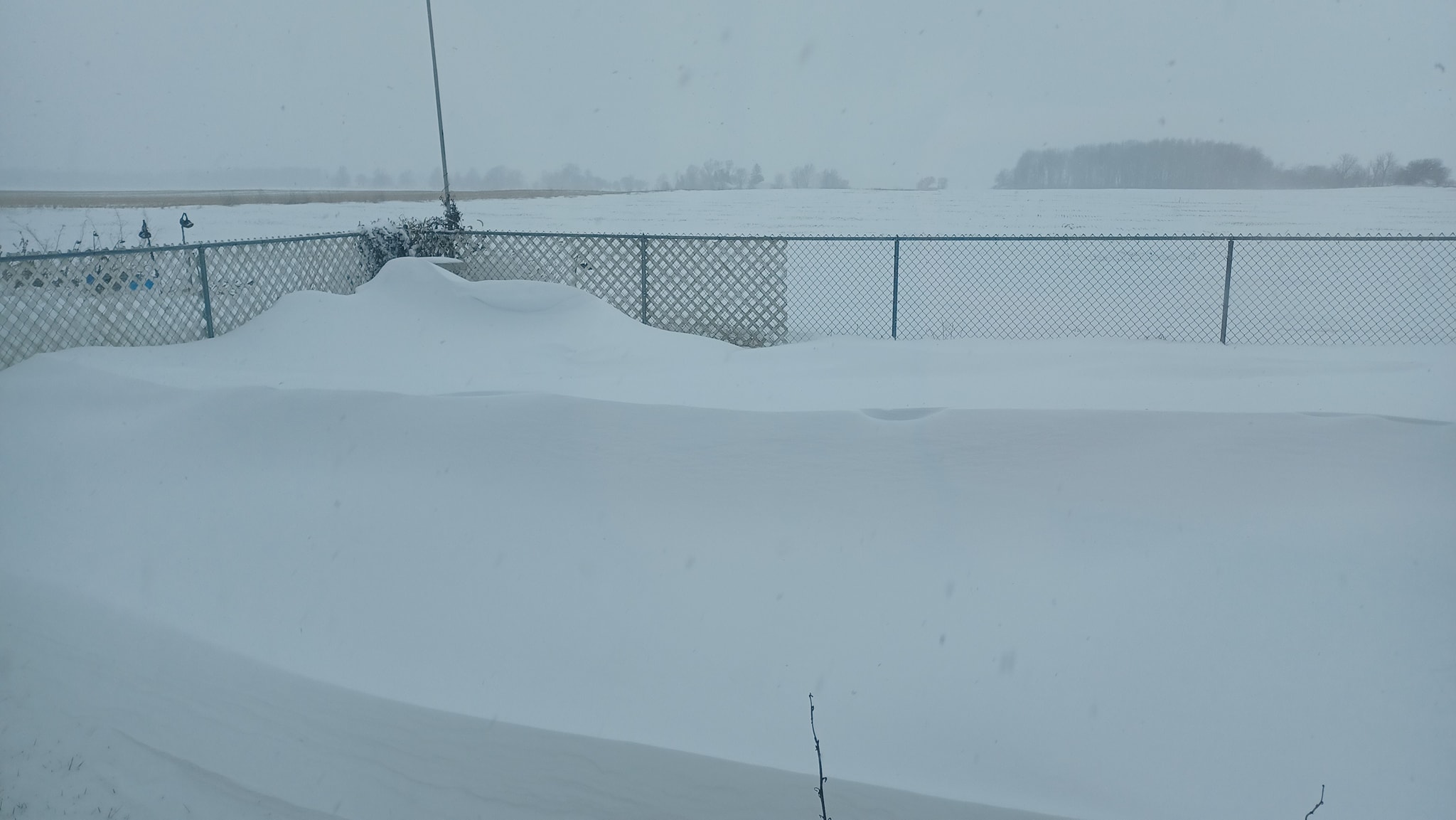
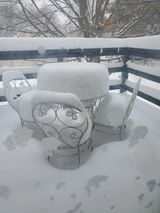
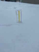
Photos & Video
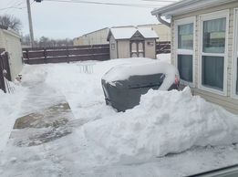
Assorted Pictures From the Snowfall
 |
 |
 |
 |
|
Courtesy of Adam Wiggington Tipton County |
Courtesy of Samia Woodward Covington, IN |
Courtesy of Megan Fennell Lafayette, IN |
Courtesy of Daun Clark Elwood, IN |
Ice Reports
Location Amount Time/Date Provider
...Indiana...
...Jackson County...
3 ENE Seymour 0.10 in 1047 AM 02/04 Public
...Jennings County...
2 NE North Vernon 0.12 in 1048 AM 02/04 Public
Radar
Radar Imagery
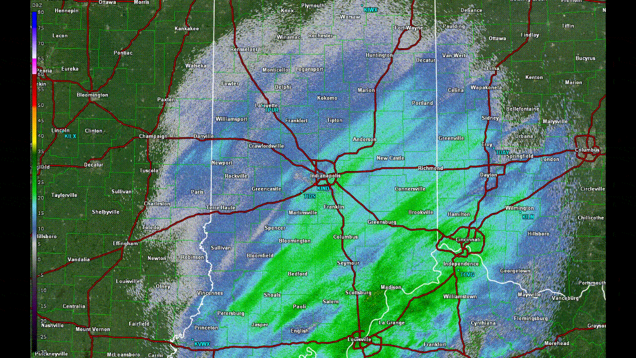
WSR-88D KIND radar beginning 12Z 2Feb2022 - 00Z 4Feb2022 Base Reflectivity.
With this radar imagery you will see the multiple waves of precipitation that moved across Indiana. You will notice the higher reflectivity south of the Indy Metro area on the afternoon of the 3rd.
The higher reflectivity was likely attributed to a couple things. One is known as bright banding, which is associated with dendrites (snow) melting as it is falling. Which means the presence of warmer air aloft was in the vicinity. The liquid that encapsulated the dendrite will reflect back higher than that of a regular dendrite, thus causing the “bright banding” appearance on radar
Environment
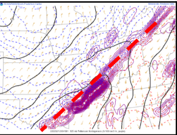
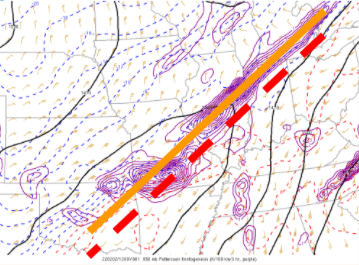
As seen from the 12Z 2Feb2022 images below, frontogenesis from 950mb to 700mb is sloped. This is common when expecting banded precipitation. What dictates the size of the banded precipitation is a result in how stable/unstable the atmosphere is. The result of this particular case was that the environment was slightly more stable, thus producing a larger area of precipitation vs a defined deformation axis common with synoptically driven winter events.
 |
 |
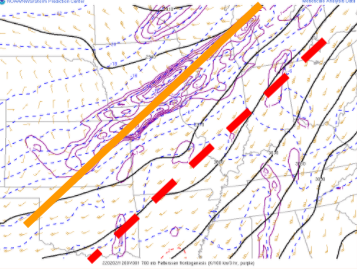 |
| Figure 1: 925mb Petterssen Frontogenesis | Figure 2: Petterssen Frontogenesis | Figure 3: 700mb Petterssen Frontogenesis |
Image below is from 18Z looking at the mean 925-850mb frontogenesis, and the gradient remaining over southern IL stretching northeast through central IN.
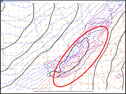 |
| Figure 4: 925-850mb Petterssen Frontogenesis |
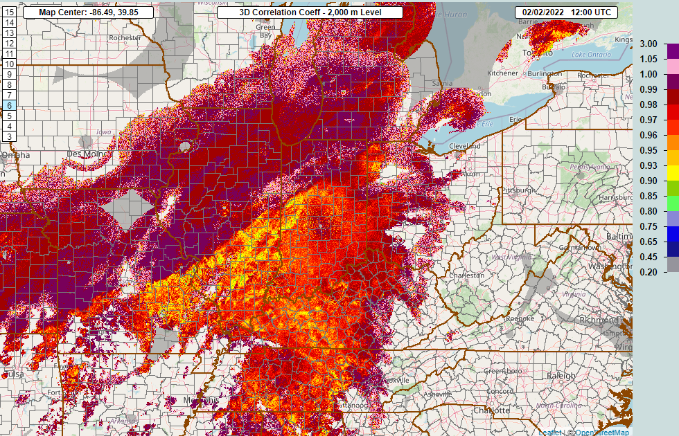
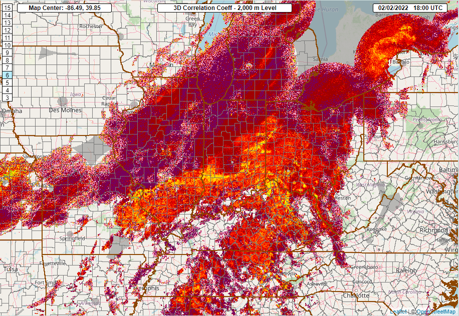
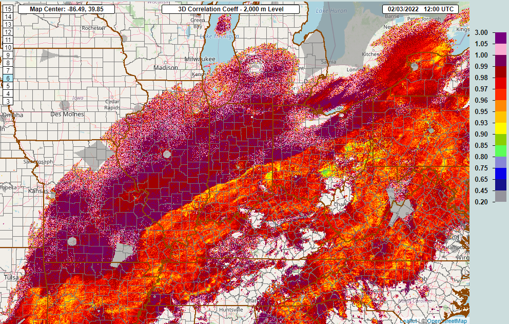
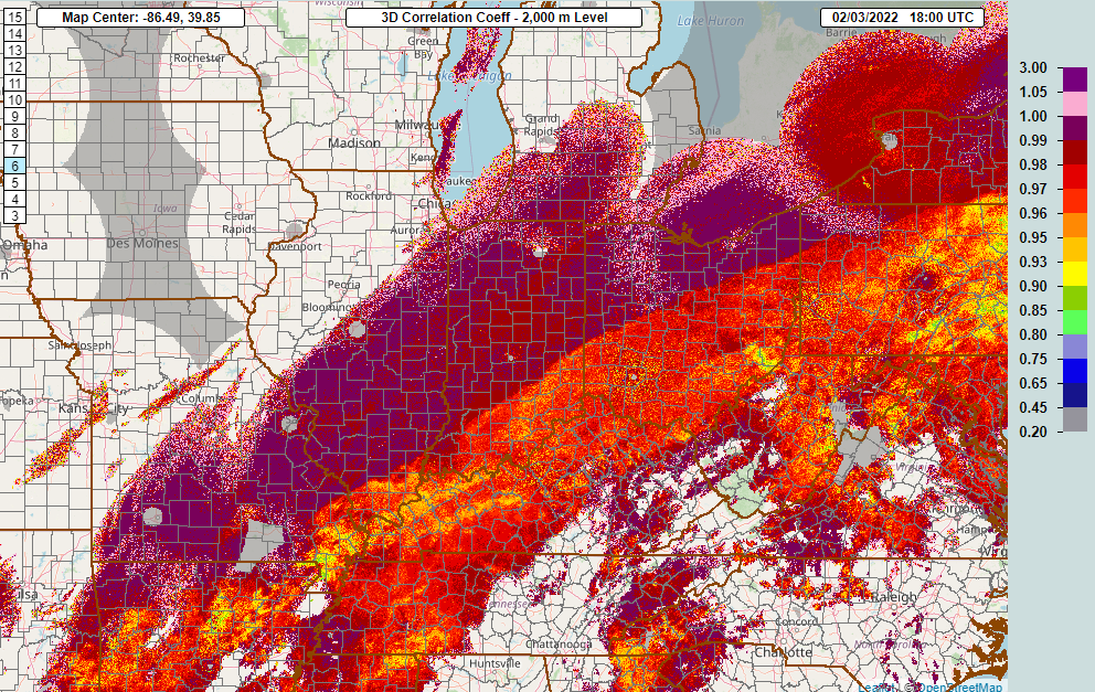
The Correlation Coefficient (CC) from the WSR-88D can show where mixed precipitation is occurring, as mixed precipitation contains many different sized particles than all of one type, e.g. snowflakes. The images below show a mosaic of CC at the 2km elevation across the region. As time passes and snow spreads slowly southeast, more of the area has a the smoother look of high CC values. (images courtesy of the MRMS program at NSSL)
 |
 |
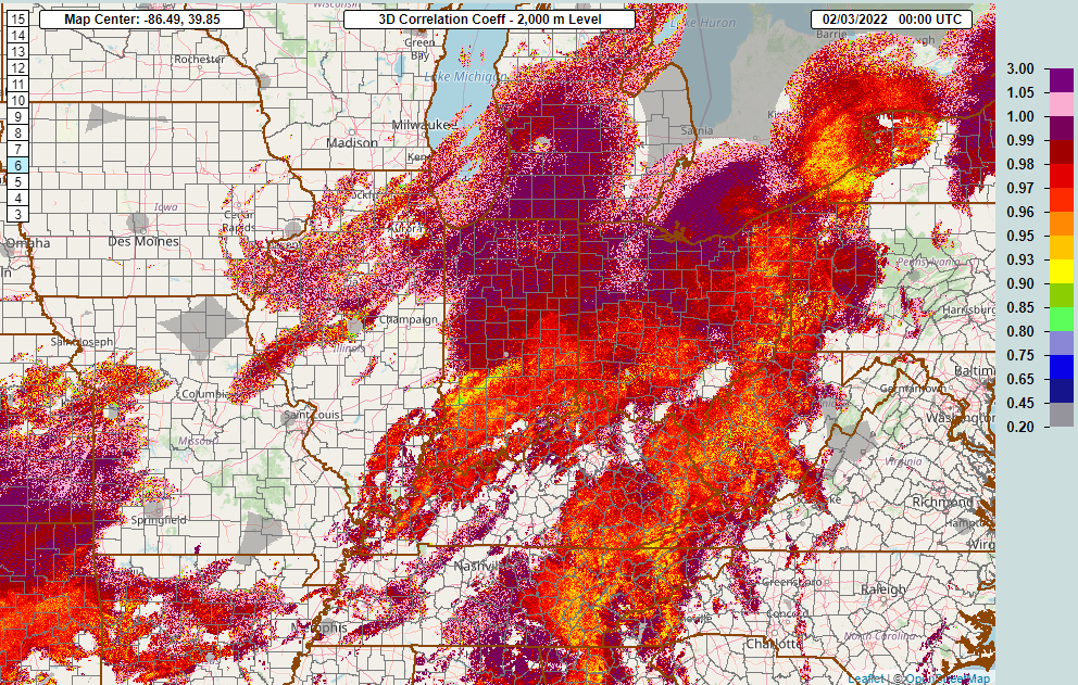 |
| Figure 5: CC at 7:00 PM EST Feb 2 | Figure 6: CC at 1:00 PM EST Feb 2 | Figure 7: CC at 7:00 PM EST Feb 2 |
 |
 |
|
| Figure 8: CC at 7:00 AM EST Feb 3 | Figure 9: CC at 1:00 PM EST Feb 3 |
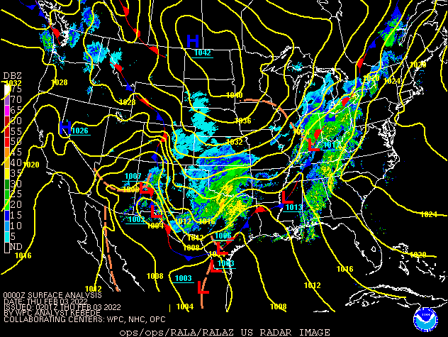
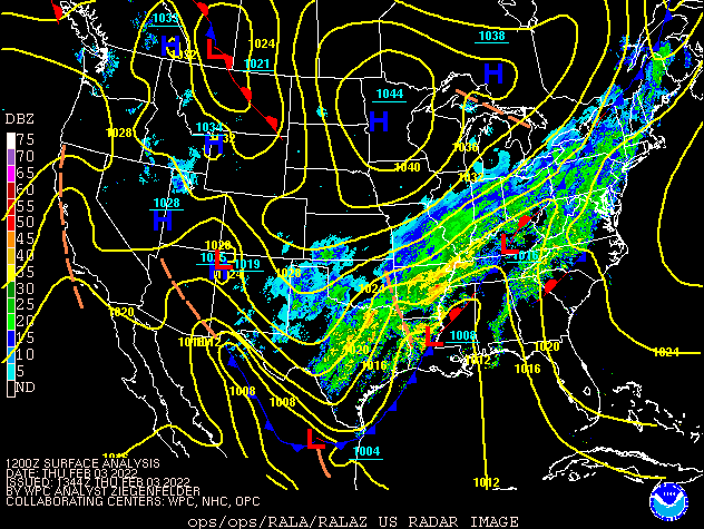
Broad southwest flow was aloft across central Indiana during the event. This kept warm air aloft for a long time, especially across southern portions of central Indiana. At the surface, cold air flowed in behind a cold front. Waves of low pressure riding long the front brought additional forcing for precipitation. Below are a couple of surface maps with radar. The upper air sounding image shows the cold air at the surface but lingering warm air aloft, which caused the mixed precipitation.
 |
 |
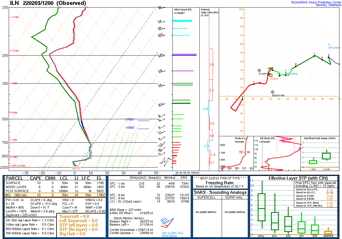 |
| Figure 10: Surface Map and Radar valid at 7:00 PM EST Feb 2 | Figure 11: Surface Map and Radar valid at 7:00 AM EST Feb 3 | Figure 12: Sounding from Wilmington, OH at 7:00 AM EST Feb 3 |
 |
Media use of NWS Web News Stories is encouraged! Please acknowledge the NWS as the source of any news information accessed from this site. |
|

