|
|
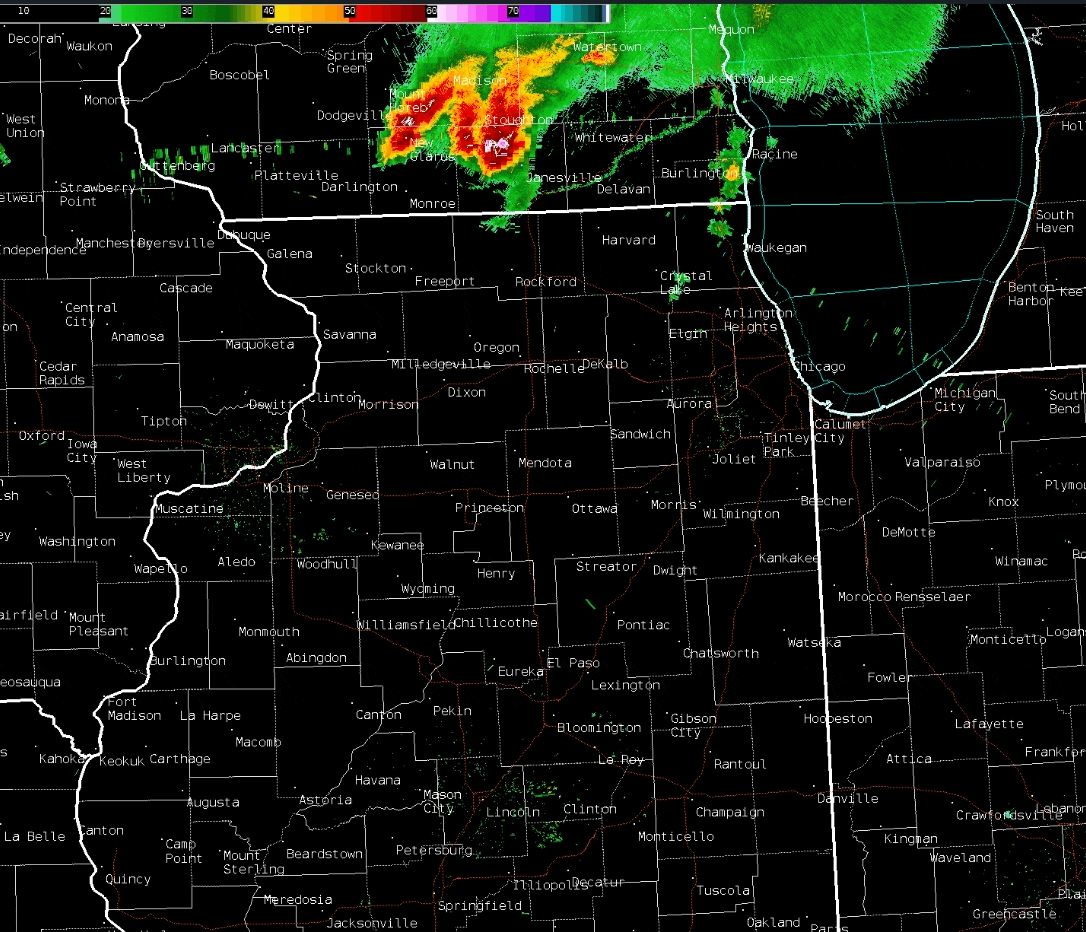
(Click to enlarge loop) Radar loop showing the multiple rounds of storms from 2 PM to 9 AM Aug 16-17th. |
Overview
August 16-17th Severe Weather
|
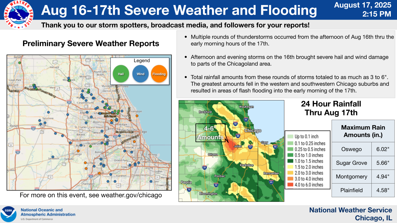
Preliminary Storm Report Map |
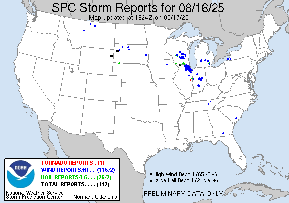
Preliminary Local Storm Report...Summary National Weather Service Chicago IL 1218 PM CDT Sun Aug 17 2025 ..TIME... ...EVENT... ...CITY LOCATION... ...LAT.LON... ..DATE... ....MAG.... ..COUNTY LOCATION..ST.. ...SOURCE.... ..REMARKS.. 0326 PM Hail 3 SSE South Beloit 42.46N 89.01W 08/16/2025 M0.75 Inch Winnebago IL Public 0340 PM Tstm Wnd Dmg Belvidere 42.26N 88.84W 08/16/2025 Boone IL Trained Spotter 3-4 foot diameter trees snapped on North Appleton Rd between Douglas and Maryland. Time estimated by radar. 0340 PM Tstm Wnd Dmg Belvidere 42.25N 88.84W 08/16/2025 Boone IL Public Seven trees down at the corner of Whitney Blvd and 2nd Street, the largest 4 feet in diameter. Power lines also down. 0340 PM Tstm Wnd Dmg 1 N Woodstock 42.33N 88.45W 08/16/2025 McHenry IL Emergency Mngr Tree on a house along Clay Street in Woodstock. Time estimated by radar. 0342 PM Tstm Wnd Dmg 1 SE Belvidere 42.25N 88.83W 08/16/2025 Boone IL Emergency Mngr Boone County EM reports numerous trees down along the southeast side of town. Time estimated by radar. 0345 PM Tstm Wnd Dmg Woodstock 42.31N 88.45W 08/16/2025 McHenry IL Law Enforcement Woodstock Police Department reports multiple power lines downed in Woodstock. Relayed by McHenry County EMA. Time estimated by radar. 0347 PM Tstm Wnd Dmg 2 NW Trout Valley 42.22N 88.29W 08/16/2025 McHenry IL Newspaper Numerous trees down, some into powerlines and on cars. Time estimated by radar. 0350 PM Tstm Wnd Dmg 1 N Belvidere 42.27N 88.84W 08/16/2025 Boone IL Trained Spotter Updated report. Two two-foot diameter trees downed near Jackson and Gardner in Belvidere. Time estimated by radar. 0351 PM Hail 2 SE Belvidere 42.24N 88.82W 08/16/2025 M1.00 Inch Boone IL Public Relayed via mping. 0351 PM Hail Woodstock 42.31N 88.44W 08/16/2025 E1.00 Inch McHenry IL Public Relayed via mping. 0351 PM Tstm Wnd Dmg 1 NNE Algonquin 42.17N 88.29W 08/16/2025 McHenry IL Public Photo shared to social media shows large branched broken from tops of trees near Main Street and Cary Road in Algonquin. Time estimated by radar. 0351 PM Tstm Wnd Dmg 1 ESE Algonquin 42.16N 88.28W 08/16/2025 McHenry IL Trained Spotter Tree down on 3 cars on Webster street near rt 62 and 31. Time estimated by radar. 0354 PM Hail 1 NW Belvidere 42.27N 88.85W 08/16/2025 M1.00 Inch Boone IL Public Report from mPING: Quarter (1.00 in.). 0358 PM Tstm Wnd Dmg 2 S Algonquin 42.13N 88.30W 08/16/2025 Kane IL Emergency Mngr Tree down on Woodcrest Lane. Time Estimated. 0359 PM Tstm Wnd Gst 2 ENE Lake in the Hills 42.19N 88.30W 08/16/2025 E52 MPH McHenry IL Public private weather station KILLAKEI23. 0400 PM Tstm Wnd Dmg 1 E Wayne 41.95N 88.25W 08/16/2025 DuPage IL NWS Employee Many large trees uprooted, large branches broken, and parts of corn fields flattened near Oak Lawn Farm (roughly Fabian and Kirk Roads). 0400 PM Tstm Wnd Dmg Fox River Grove 42.20N 88.22W 08/16/2025 McHenry IL Trained Spotter Photos showed numerous trees and tree limbs blown down from Lions Park through the Foxmoor Subdivision. Some trees were uprooted. 0402 PM Tstm Wnd Dmg 1 NE Carpentersville 42.14N 88.25W 08/16/2025 Kane IL Public Public report of multiple branches broken from tree near Carpentersville. 0402 PM Tstm Wnd Dmg 2 NNE Carpentersville 42.15N 88.24W 08/16/2025 Kane IL Public Two large trees were blown down onto County Line Road near the Cook-Kane County border. 0402 PM Tstm Wnd Dmg 1 N Fox River Grove 42.21N 88.22W 08/16/2025 McHenry IL Public Numerous photos shared to social media of large branches broken in and near Cary. At least one tree uprooted. Time estimated by radar. 0404 PM Tstm Wnd Dmg 1 S Sleepy Hollow 42.08N 88.32W 08/16/2025 Kane IL Emergency Mngr Tree blown down into the road near Sleepy Hollow Road and Boncosky Road. Time Estimated. 0404 PM Hail 1 SW Port Barrington 42.23N 88.22W 08/16/2025 E1.50 Inch McHenry IL Public Relayed via mping. 0405 PM Tstm Wnd Dmg 2 NE Barrington Hills 42.16N 88.16W 08/16/2025 Lake IL Public Downed trees, branches, and power lines. Hail of unknown size as well. Time estimated from radar. 0405 PM Hail Cary 42.21N 88.23W 08/16/2025 M1.25 Inch McHenry IL Public Relayed via mping. 0406 PM Tstm Wnd Dmg 2 ESE Fox River Grove 42.19N 88.19W 08/16/2025 Lake IL Public Photo shared via social media shows several inch diameter branch broken near Northwest Highway and Kelsey Road. Time estimated by radar. 0408 PM Tstm Wnd Dmg 1 N Barrington Hills 42.16N 88.17W 08/16/2025 Lake IL Local Official Village of Barrington reported via social media that multiple tree branches broken in the area. Public report of large tree branch blocking Oak Knoll Road west of Barrington. Time estimated by radar. 0410 PM Tstm Wnd Dmg 2 E Elgin 42.04N 88.24W 08/16/2025 Cook IL Public 1 inch diameter branches broken near Elgin due to thunderstorm outflow. 0410 PM Tstm Wnd Gst 4 SW Pingree Grove 42.02N 88.46W 08/16/2025 E65 MPH Kane IL Trained Spotter near RT 47 and Plato. 0412 PM Tstm Wnd Dmg 4 NE Lily Lake 42.00N 88.43W 08/16/2025 Kane IL Emergency Mngr Tree down blocking Lenz Road near Muirhead Road. Time Estimated. 0419 PM Tstm Wnd Gst 4 N Sycamore 42.04N 88.68W 08/16/2025 M54 MPH De Kalb IL Public Private weather station. 0421 PM Tstm Wnd Dmg 1 NW DeKalb 41.94N 88.77W 08/16/2025 De Kalb IL Emergency Mngr Photos depict an uprooted softwood tree and 8 to 12 inch diameter tree limb snapped in the vicinity of Greenbrier Court. Time estimated by radar. 0422 PM Tstm Wnd Dmg Bartlett 42.00N 88.19W 08/16/2025 Cook IL Trained Spotter 1 ft diameter tree snapped at Spaulding and Stroger. 0423 PM Tstm Wnd Dmg Hoffman Estates 42.08N 88.12W 08/16/2025 Cook IL Trained Spotter Several tree limbs 8 to 12 inches in diameter were blown down near Mundhank Road and South Freeman Road. 0425 PM Hail 1 E Palatine 42.11N 88.02W 08/16/2025 M1.25 Inch Cook IL Cocorahs 0425 PM Tstm Wnd Dmg 2 SE Palatine 42.10N 88.01W 08/16/2025 Cook IL Public Multiple photos shared to social media show numerous branches broken southeast of Palatine. Most branches at least multiple inches in diameter. At least one tree trunk split and another tree uprooted. Time estimated by radar. 0426 PM Tstm Wnd Gst 1 NW Palatine 42.13N 88.06W 08/16/2025 E55 MPH Cook IL Public private weather station. 0426 PM Tstm Wnd Dmg 2 NE DeKalb 41.95N 88.72W 08/16/2025 De Kalb IL Public Photo shared to social media shows large tree branch broken between Dekalb and sycamore. Time estimated by radar. 0426 PM Tstm Wnd Gst 3 NNW DeKalb 41.97N 88.78W 08/16/2025 M73 MPH De Kalb IL Mesonet 0428 PM Hail Rolling Meadows 42.08N 88.03W 08/16/2025 M1.00 Inch Cook IL Trained Spotter Harper College. Multiple large branches also broken. 0429 PM Tstm Wnd Gst 1 WNW Rolling Meadows 42.08N 88.04W 08/16/2025 E53 MPH Cook IL Public Private weather station KILPALAT92. 0430 PM Tstm Wnd Dmg Schaumburg 42.03N 88.09W 08/16/2025 Cook IL Public Photos and videos shared to social media show few inch diameter branches downed. Rotted tree uprooted or snapped in vicinity. Time estimated by radar. 0430 PM Tstm Wnd Dmg Rolling Meadows 42.08N 88.02W 08/16/2025 Cook IL Public Photos showed numerous tree limbs blown down on Cardinal Drive. 0433 PM Hail Arlington Heights 42.08N 87.98W 08/16/2025 M1.00 Inch Cook IL Trained Spotter 1333 Chicago Ave. 0435 PM Tstm Wnd Dmg 2 SSW Mount Prospect 42.04N 87.95W 08/16/2025 Cook IL Emergency Mngr Portion of roof removed from apartment building near Huntington Commons Road and Linneman Road in Mount Prospect. Photo shared via social media shows debris from roof damaged nearby cars. Time estimated by radar. Relayed by 911 dispatch center. 0436 PM Tstm Wnd Gst 1 S Ohare Airport 41.97N 87.90W 08/16/2025 M54 MPH Cook IL Mesonet ITWS south airfield at ORD. 0436 PM Tstm Wnd Gst 1 SSE South Barrington 42.07N 88.14W 08/16/2025 M56 MPH Cook IL Public Private wx station KILHOFFM60. 0438 PM Hail 1 S Des Plaines 42.03N 87.89W 08/16/2025 E1.00 Inch Cook IL Public 0439 PM Hail 1 SE Mount Prospect 42.05N 87.92W 08/16/2025 M1.00 Inch Cook IL Public Report from mPING: Quarter (1.00 in.). 0439 PM Tstm Wnd Dmg 3 S Maple Park 41.86N 88.60W 08/16/2025 Kane IL Emergency Mngr Power pole snapped near Harter Road and County Line Road south of Maple Park. Time estimated by radar. 0440 PM Tstm Wnd Dmg 2 NW Niles 42.05N 87.84W 08/16/2025 Cook IL Newspaper Newspaper article with pictures showing numerous tents blowen around and destroyed at the Niles Founders Day festivities at Golf Mill Park. Also was some downed trees. Time approximated by radar. 0444 PM Hail Des Plaines 42.05N 87.88W 08/16/2025 M1.25 Inch Cook IL Public Report from mPING: Half Dollar (1.25 in.). 0444 PM Tstm Wnd Dmg Kaneville 41.84N 88.52W 08/16/2025 Kane IL Emergency Mngr flattened corn near Main street just west of Bunker Road. Time estimated by radar. 0444 PM Tstm Wnd Dmg Elburn 41.89N 88.47W 08/16/2025 Kane IL Emergency Mngr Trees down on power lines and vehicles. Time estimated. 0451 PM Tstm Wnd Dmg 2 NNE Sugar Grove 41.80N 88.43W 08/16/2025 Kane IL Emergency Mngr Tree down on Bliss Road. Time Estimated. 0453 PM Tstm Wnd Dmg 1 NNW Sandwich 41.66N 88.63W 08/16/2025 De Kalb IL Emergency Mngr Photo shows large branch broken near Pleasant Avenue and Castle Street in Sandwich. Time estimated by radar. 0453 PM Tstm Wnd Dmg 4 W North Aurora 41.81N 88.40W 08/16/2025 Kane IL Emergency Mngr Trees down on houses and trees blocking roads near Tanner Road and Terrace Drive. Time Estimated. 0455 PM Tstm Wnd Dmg 2 NE Sugar Grove 41.78N 88.43W 08/16/2025 Kane IL Public Trees up to one foot diameter downed or split. Multiple trees blocking Bliss Road. Time estimated from radar and other reports. 0455 PM Tstm Wnd Dmg 2 NE Sugar Grove 41.78N 88.42W 08/16/2025 Kane IL Emergency Mngr Tree blown down on Winthrop New Road. Time Estimated. 0500 PM Tstm Wnd Dmg 1 SW North Aurora 41.79N 88.34W 08/16/2025 Kane IL Emergency Mngr Tree down blocking Exposition Avenue. Time Estimated. 0503 PM Tstm Wnd Dmg 1 S Lisle 41.78N 88.07W 08/16/2025 DuPage IL Public Photos shared on social media show several 3 to 6 inch diameter tree limbs down as well as a 12 inch diameter tree snapped at base in the vicinity of the intersection of Short Street and Rt 53. 0503 PM Tstm Wnd Dmg 2 NNW Montgomery 41.75N 88.36W 08/16/2025 Kane IL Emergency Mngr Trees down on power lines and vehicles near Prairie Street and Edgelawn Drive. Time Estimated. 0506 PM Tstm Wnd Dmg Aurora 41.76N 88.31W 08/16/2025 Kane IL Public Photo shared on social media showed a large section of a healthy tree split and blocking part of a residential road. 0512 PM Hail 1 NE Woodridge 41.77N 88.03W 08/16/2025 M1.00 Inch DuPage IL Public Photo shared on social media shows 1 hail. 0514 PM Hail 3 SW Naperville 41.75N 88.20W 08/16/2025 E1.50 Inch DuPage IL Public Relayed via mping. 0522 PM Tstm Wnd Dmg 1 SW Arlington Heights 42.07N 87.99W 08/16/2025 Cook IL Public Public report of a large tree branch downed in Arlington Heights. 0527 PM Tstm Wnd Gst 1 N Crystal Lawns 41.58N 88.16W 08/16/2025 E54 MPH Will IL Public Near Louis Joliet Mall. 0532 PM Tstm Wnd Gst NWS Chicago-Romeoville 41.60N 88.08W 08/16/2025 M56 MPH Will IL Official NWS Obs 0535 PM Tstm Wnd Dmg 1 SE Romeoville 41.64N 88.08W 08/16/2025 Will IL NWS Employee Photo shared to social media shows roofing material pulled from strip mall near Romeo Road and IL-53. Time estimated by radar. 0536 PM Funnel Cloud 2 NNW Symerton 41.36N 88.07W 08/16/2025 Will IL Public Updates previous funnel cloud report from Wilmington. Multiple photos and videos shared on social media show a funnel cloud in Will County. Video taken from Elwood appears to be facing south southeast. Most likely location appears to be over the Midewin Prairie. Time estimated by radar. 0540 PM Tstm Wnd Dmg New Lenox 41.51N 87.97W 08/16/2025 Will IL Public Very large tree limbs snapped and blown down the street. 0543 PM Tstm Wnd Dmg 1 ENE Lockport 41.59N 88.05W 08/16/2025 Will IL Public Multiple photos shared to social media show large branches broken in Lockport. Some branches at least several inches in diameter. One large trunk of a rotted tree fell on a house. Time estimated by radar. 0544 PM Tstm Wnd Dmg 1 SE Lockport 41.58N 88.05W 08/16/2025 Will IL NWS Employee Whole trees snapped in the vicinity of Lockport High School baseball fields. 0544 PM Tstm Wnd Gst 2 NNW Manhattan 41.45N 88.00W 08/16/2025 M56 MPH Will IL Public Private Weather Station. 0557 PM Tstm Wnd Dmg 4 E Manhattan 41.45N 87.92W 08/16/2025 Will IL Public Public report of small branches broken east of Manhattan. 0856 PM Tstm Wnd Dmg 2 W Piper City 40.75N 88.22W 08/16/2025 Ford IL Emergency Mngr Tree in roadway with power lines down near intersection of 1300 E and 2450 N near Piper City. Time estimated by radar. 0155 AM Tstm Wnd Gst Algonquin 42.17N 88.30W 08/17/2025 M63 MPH McHenry IL Public Social media report of 63.2 mph wind gust on personal weather station. 0224 AM Tstm Wnd Gst Ohare Airport 41.98N 87.90W 08/17/2025 M63 MPH Cook IL ASOS Corrects previous tstm wnd gst report from Ohare Airport. ASOS station KORD Chicago OHare. 0230 AM Tstm Wnd Dmg 1 WSW Bensenville 41.95N 87.96W 08/17/2025 DuPage IL Public Numerous trees down with power outages. 0233 AM Tstm Wnd Dmg Glen Ellyn 41.88N 88.07W 08/17/2025 DuPage IL Public Large tree at least 1 foot in diameter uprooted blocking street. Time estimated by radar. 0235 AM Tstm Wnd Gst 1 N La Grange Park 41.84N 87.87W 08/17/2025 M61 MPH Cook IL Public Measured wind gust of 61 mph. 0238 AM Tstm Wnd Dmg 2 WSW York Center 41.84N 88.03W 08/17/2025 DuPage IL Public Several downed trees and limbs. 0239 AM Tstm Wnd Dmg 2 SSW York Center 41.83N 88.01W 08/17/2025 DuPage IL Local Official Highland Ave closed at 31st street due to downed power lines. 0246 AM Tstm Wnd Dmg 1 S Downers Grove 41.78N 88.01W 08/17/2025 DuPage IL Public Several large tree limbs at least 6 to 12 inches in diameter downed near 59th and Carpenter. 0250 AM Tstm Wnd Gst 1 N La Grange Park 41.84N 87.87W 08/17/2025 M57 MPH Cook IL Public 0252 AM Tstm Wnd Dmg 2 S Downers Grove 41.77N 88.01W 08/17/2025 DuPage IL NWS Employee Downed power lines, snapped trunk and several large branches down in the vicinity of 63rd St and Main St. 0256 AM Tstm Wnd Gst 2 SE Oak Lawn 41.70N 87.73W 08/17/2025 M55 MPH Cook IL Public Personal weather station KILOAKLA63. 0258 AM Tstm Wnd Dmg Markham 41.59N 87.69W 08/17/2025 Cook IL Public Photo shared on social media shows 8 inch diameter tree limb snapped. Time estimated by radar. 0258 AM Tstm Wnd Gst 3 SW Burbank 41.71N 87.81W 08/17/2025 M60 MPH Cook IL CO-OP Observer Corrects previous tstm wnd gst report from 1 NNE Palos Hills. Peak wind gust of 60 mph. 0259 AM Tstm Wnd Dmg 1 S Oak Forest 41.59N 87.75W 08/17/2025 Cook IL Public Large tree reported down on 167 street east of Central Ave. Time estimated by radar. 0302 AM Tstm Wnd Dmg Harvey 41.61N 87.65W 08/17/2025 Cook IL Public Tree at least one foot in diameter snapped at base. 0311 AM Tstm Wnd Dmg Crete 41.44N 87.63W 08/17/2025 Will IL Emergency Mngr Photo shows a large tree and power lines blown down blocking the road near Exchange Street and Perry Street. Additional trees and power lines blown down near Selleck Street and Cass Street. Time Estimated. 0330 AM Tstm Wnd Gst 2 W St. John 41.45N 87.51W 08/17/2025 M67 MPH Lake IN Public Personal weather station KINSAINT45. 0331 AM Tstm Wnd Dmg Markham 41.60N 87.69W 08/17/2025 Cook IL Public Multiple trees and wires down. 0446 AM Lightning 1 NE Downers Grove 41.80N 88.00W 08/17/2025 DuPage IL Public Report of a house fire caused by a lightning strike. 0449 AM Tstm Wnd Dmg Momence 41.16N 87.66W 08/17/2025 Kankakee IL Public Power lines down in the town. && $$ |
August 16-17th Heavy Rain and Flash Flooding
 |
| Maximum 2-hour rainfall |
Flash Flood Reports:
Preliminary Local Storm Report...Summary National Weather Service Chicago IL 201 PM CDT Sun Aug 17 2025 ..TIME... ...EVENT... ...CITY LOCATION... ...LAT.LON... ..DATE... ....MAG.... ..COUNTY LOCATION..ST.. ...SOURCE.... ..REMARKS.. 0237 AM Flash Flood Rogers Park - Chicago 42.01N 87.67W 08/17/2025 Cook IL Public North Paulina Street Flooded. 0249 AM Flash Flood 1 NW Midway Airport 41.79N 87.77W 08/17/2025 Cook IL Public Reports on social media of basement flooding in Garfield Ridge. 0255 AM Flash Flood 1 N Archer Hts. - Chica 41.82N 87.72W 08/17/2025 Cook IL Broadcast Media Interstate 55 closed in both directions at Pulaski Road due to flooding. Time Estimated. 0255 AM Flash Flood 1 ESE Archer Hts. - Chi 41.81N 87.71W 08/17/2025 Cook IL Broadcast Media At least 4 cars stranded in flood waters near West 47th Street and South Archer Avenue. Time estimated. 0305 AM Flash Flood 1 SE Chicago Lawn 41.76N 87.68W 08/17/2025 Cook IL Broadcast Media Flooded viaduct near West 75th Street and South Western Avenue. Time Estimated. 0308 AM Flash Flood 1 E Wood Dale 41.97N 87.96W 08/17/2025 DuPage IL Public 2 feet of standing water in back yard and sidewalk. 0310 AM Flash Flood 1 NNW Pullman - Chicago 41.72N 87.60W 08/17/2025 Cook IL Broadcast Media At least two cars stuck in flood waters under a viaduct on East 95th Street near South Cottage Grove Avenue. Time Estimated. 0325 AM Flood Hammond 41.66N 87.51W 08/17/2025 Lake IN Public Photo shared on social media showed flood waters up to one foot deep on 131st Place. Time Estimated. 0400 AM Flash Flood Gage Park - Chicago 41.79N 87.70W 08/17/2025 Cook IL Public Photo shows at least 6 inches of water flooding of roadways and sidewalks in Gage Park. 0430 AM Flash Flood Boulder Hill 41.71N 88.34W 08/17/2025 Kendall IL Trained Spotter A car floating in the water in Bouder Hill, along with significant basement flooding reported. Time is approximate. 0433 AM Flash Flood 1 SW Joliet 41.52N 88.10W 08/17/2025 Will IL Public Report of a car stranded in flooded roadway near Center Street before I-80. 0435 AM Flash Flood 1 N Oswego 41.69N 88.36W 08/17/2025 Kendall IL Broadcast Media Standing water 3 to 4 feet deep was reported in Fox Chase Subdivision. Time Estimated. 0445 AM Flash Flood 1 E Crest Hill 41.56N 88.09W 08/17/2025 Will IL Public Social media report of Route 53 closed in both directions at the railroad viaduct south of Caton Farm Road due to flooding. Street flooding also reported at Route 53 and Theodore Street. Time Estimated. 0840 AM Flood 3 W Plainfield 41.61N 88.26W 08/17/2025 Will IL NWS Employee Water over road on West Lockport Road and County Line Road. 1030 AM Flood 4 SW Plainfield 41.56N 88.25W 08/17/2025 Will IL Broadcast Media Pictures shared to social media of Caton Farm Road flooded and closed at Joe Adler Drive. && $$ |
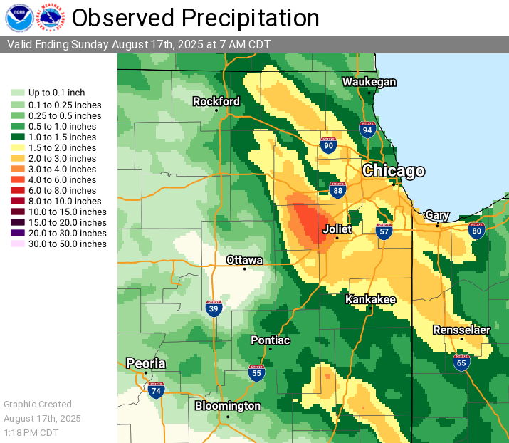
Selected Rainfall Reports:
Preliminary Local Storm Report...Summary National Weather Service Chicago IL 201 PM CDT Sun Aug 17 2025 ..TIME... ...EVENT... ...CITY LOCATION... ...LAT.LON... ..DATE... ....MAG.... ..COUNTY LOCATION..ST.. ...SOURCE.... ..REMARKS.. 0700 AM Rain 1 NNE Oswego 41.69N 88.35W 08/17/2025 M6.02 Inch Kendall IL Mesonet Private weather station observation. Total rainfall since last afternoon. 5.42 inches between 3 and 7am. 0700 AM Rain 3 SE Sugar Grove 41.73N 88.41W 08/17/2025 M5.66 Inch Kane IL Mesonet Private weather station observation. Total rainfall since last afternoon. 4.88 inches between 3 and 7am. 0700 AM Rain 1 NNW Oswego 41.69N 88.36W 08/17/2025 M5.23 Inch Kendall IL Cocorahs Cocorahs station IL-KD-127 Oswego. 24 hour total. Most rain occurred between 3am and 7am. 0616 AM Rain 1 SSE Boulder Hill 41.70N 88.33W 08/17/2025 M5.10 Inch Kendall IL Cocorahs Cocorahs station IL-KD-136 Oswego. 24 hour total. Most rain occurred between 3am and 6am. 0700 AM Rain 3 NW Oswego 41.71N 88.40W 08/17/2025 M4.96 Inch Kendall IL Cocorahs Cocorahs station IL-KD-99 Oswego 3 NW. 24 hour total. Most rain occurred between 3am and 7am. 0700 AM Rain 1 WNW Montgomery 41.73N 88.35W 08/17/2025 M4.94 Inch Kane IL Mesonet Private weather station observation. Total rainfall since last afternoon. 4.46 inches between 3 and 7am. 0700 AM Rain 4 SW Plainfield 41.57N 88.27W 08/17/2025 M4.58 Inch Kendall IL Cocorahs Cocorahs station IL-KD-34 Plainfield 4 SW. 0630 AM Rain 2 SE Boulder Hill 41.69N 88.31W 08/17/2025 M4.50 Inch Kendall IL Cocorahs Cocorahs station IL-KD-126 Boulder Hill. 24 hour total. Most rain occurred between 3am and 630am. 0700 AM Rain 1 N Shorewood 41.53N 88.20W 08/17/2025 M4.21 Inch Will IL Cocorahs Cocorahs station IL-WL-122 Shorewood. 0700 AM Rain 1 NNW Sugar Grove 41.78N 88.45W 08/17/2025 M4.08 Inch Kane IL Cocorahs Cocorahs station IL-KN-4 Sugar Grove 1 NNW. 0700 AM Rain 2 NW Plainfield 41.63N 88.23W 08/17/2025 M3.98 Inch Will IL Cocorahs Cocorahs station IL-WL-171 Plainfield 1.7 WNW. 24 hour total. Most rain occurred between 3am and 7am. 0700 AM Rain 1 WSW Crest Hill 41.55N 88.13W 08/17/2025 M3.58 Inch Will IL CO-OP Observer CO-OP Observer station JKJI2 Joliet 2 N. 0700 AM Rain 2 W Aurora 41.76N 88.35W 08/17/2025 M3.42 Inch Kane IL Cocorahs Cocorahs station IL-KN-123 Aurora 2 W. 0700 AM Rain 4 S Sugar Grove 41.71N 88.43W 08/17/2025 M3.42 Inch Kendall IL Cocorahs Cocorahs station IL-KD-157 Yorkville 4.5 N. && $$ |
 |
Media use of NWS Web News Stories is encouraged! Please acknowledge the NWS as the source of any news information accessed from this site. Additional event recaps can be found on the NWS Chicago Past Events Page |
|