 |
||||
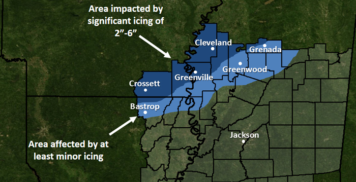
Impact Map
The map below represents the approximate area within the NWS Jackson forecast area impacted by the February 1994 ice storm. Areas shaded in light blue experienced at least some icing, mainly during the late night hours of February 9th into the morning hours of February 10th. Areas shaded in a darker blue experienced a more prolonged period of icing beginning on the evening of February 9th lasting into the morning of February 11th.
Event Summary
Sharp Cold Front
Beginning early Wednesday February 9th at around midnight, temperatures were around 70 degrees across the Delta, and they remained in the upper 60s to near 70 until a cold front pushed through the area around sunrise that morning. Behind the front, light to moderate rain showers began and continued through essentially the entire daytime. Meanwhile, temperatures continued to fall in the wake of the front, to 46 at Greenville by 8 AM, 39 by 1 PM, and 34 by 7 PM. The last observation taken at the Greenville Airport for the duration of the storm was at 8 PM that night. The temperature had fallen to 28 and the rain had become a mixture of freezing rain and sleet. Commercial flights would not resume until the following Wednesday, February 16th.
Ice Accumulations Begin
Not coincidentally, the first reports of utility issues began around the same time temperatures fell below freezing - around 8 PM at Greenville. Ice accumulations caused tree branches to fall on utility lines. Then eventually, entire trees began to fall. Freezing rain continued through the night across the Delta as the freezing line crept farther south. By morning, ice was affecting a large portion of the Delta, with light icing as far south of Bastrop, Lake Providence, Rolling Fork, Isola, and Winona.
On the morning of Thursday February 10th, ice accumulations covered the widest extent of the Delta they would throughout the entire storm. Temperatures were in the upper 20s across much of southeast Arkansas and Washington, Bolivar, Sunflower, and northern Leflore counties. Through the day, temperatures warmed just a few degrees. This was enough to alleviate ice-related issues across northeast Louisiana and in Issaquena, Sharkey, Humphreys, southern Leflore, Carroll, Montgomery, Webster, and Grenada counties. In fact, the cities of Greenwood and Grenada largely escaped any significant ice-related issues throughout the storm. However, farther north, the temperature never rose above freezing that day, and while neighbors to the south were thawing out, the heart of the Delta saw bad turn to worse.
The Disaster Unfolds
Along a corridor from Crossett, Hamburg, and Lake Village in Arkansas through Greenville, Cleveland, Indianola, Minter City and points north in Mississippi, ice continued to accumulate through the day Thursday. Making matters worse, a new low pressure system developed in the northwestern Gulf of America along the front that had pushed through the area on Wednesday. This low tracked along the front toward the Mississippi coast on Thursday, spreading a new round of heavy precipitation northward across the state. Moderate freezing rain, which was already enough to cause significant issues Wednesday night and Thursday morning, became heavy freezing rain with thunder around noon on Thursday. This caused a significant escalation of issues as ice accumulated quickly on trees, power and phone lines, and utility poles. It was now impossible for utility companies to keep up with falling lines, snapping poles, and snapping trees. All they could do was attempt to maintain utilities for hospitals, nursing homes, emergency responders, and other priority customers. The heavy precipitation also caused flooding, which was only made worse by storm drains clogged with tree debris. Several fields across the Delta were flooded as surrounding trees were full of ice.
The intensity of the freezing rain began to subside by the evening hours, but light freezing rain and freezing drizzle persisted through the overnight hours of Thursday February 10th into the morning of Friday February 11th. All told, up to 3 to 6 inches of ice accumulated in the hardest hit areas. One of the reports of 6" accumulation came from Mississippi Power & Light workers in Greenville who found a diameter of one foot of ice on some power lines (this is 6" of ice, measuring from the line through the ice). This ice caused 95 foot tall steel transmission towers with 42 inch concrete bases to collapse. Engineers estimated the lines would have been supporting up to 39 tons of ice!
A Slow Thaw
Temperatures finally warmed to above freezing during the daytime hours of February 11th, but only by a few degrees in the hardest-hit areas. The slow thaw continued into the weekend, as temperatures finally reached the 40s by Saturday.
Across northern Mississippi, approximately 3.7 million acres of commercial forestland was significant damaged, with the value of damaged timber estimated to be $1.3 billion. Damage to trees in urban areas was estimated to be another $27 million. In Arkansas, Georgia-Pacific reported 500,000 acres of timberland affected. Twenty-five percent of Mississippi's pecan crop was destroyed and impacted for years to come, at an estimated cost of $5.5 million per year. Nearly 750,000 customers were without power at some point across North Mississippi, with some outages lasting up to a month. Over 8,000 utility poles were pulled down by the weight of the ice, and over 4,700 miles of lines were downed. About 490 water systems were impacted, with as many as 741,000 customers without water at some point. Systemwide, Entergy had 250,000 to 300,000 customers without power in Mississippi, Louisiana, and Arkansas.
By most accounts, this was the worst ice storm to impact the ArkLaMiss Delta since January of 1951.
Acknowledgements
We are appreciative of the following individuals and groups, who aided in the gathering of information for this webpage.

