|
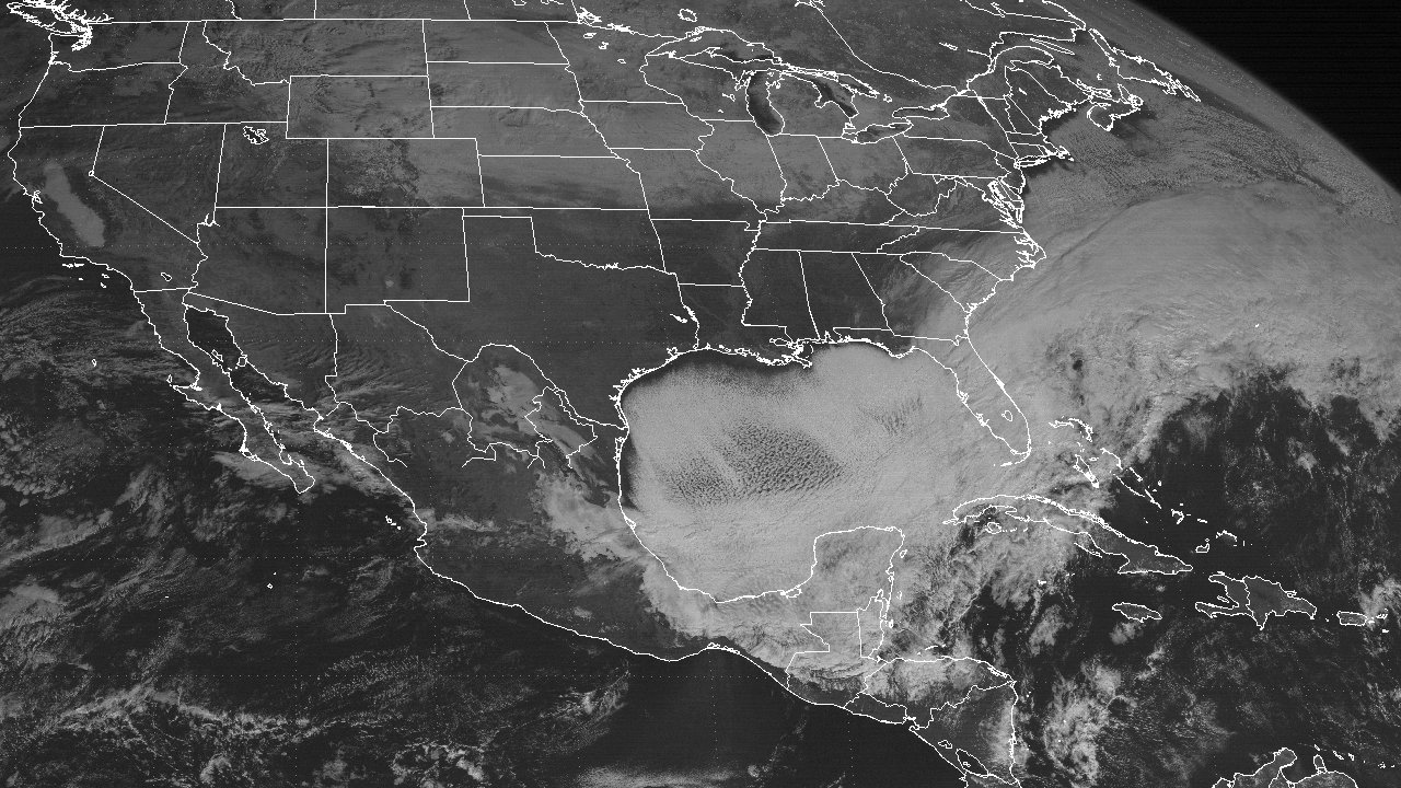
Above: GOES 7 Visible Satellite Image at 11:01 AM CST December 23, 1989 showing snow cover over coastal Louisiana and the cold air stratocumulus clouds over the Gulf and Atlantic.
A large mid to upper-level longwave trough over North America with the classic cutoff low, or “polar vortex” over Canada was present mid to late December 1989. By December 19th and 20th, the large mid to upper-level cutoff low moved southeast towards the Great Lakes. This allowed for deepening of the longwave trough axis over North America, roughly paralleling the Rockies to the east. This scenario allowed for a very frigid Arctic airmass over Western Canada to plunge rapidly south southeast across the Midwest to the Gulf and eastward December 21st through the 26th. Very similar situation to the December 1983 Record Arctic Cold Outbreak, record low temperatures were established once again over most locations, in some cases breaking the December 1983 records.
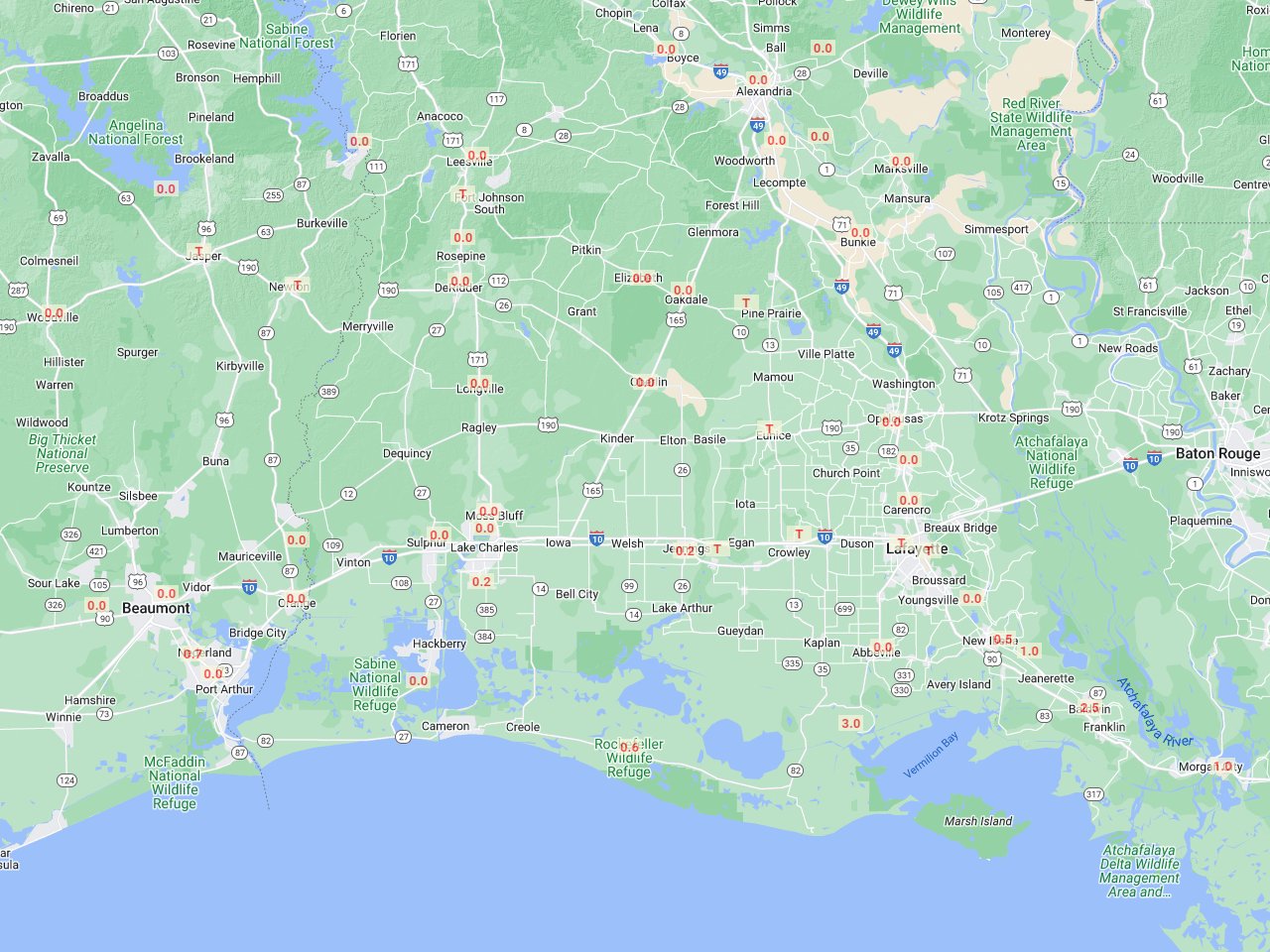
For our region, the assault of very frigid air behind the cold front arrived late on December 21st into the morning hours of December 22nd. Temperatures rapidly dropped into the teens just before daybreak on the 22nd, coupled with strong northerly winds of 25 mph with gusts to 35 mph. Temperatures for the most part remained in the teens to lower 20s for the remainder of the day due to the cloud cover and cold air advection. During this time, a weak surface low along the cold front in the Gulf formed and generated freezing rain and sleet across the Gulf oil and gas production platforms, and 1 to 4 inches of snow across coastal Cameron, Vermilion, Iberia, and St. Mary parishes. Lingering snowfall can be seen in this closeup GOES 7 Visible Satellite Image at 11:00 AM CST December 23rd.
Temperatures continued to plummet the night of December 22nd into the morning of December 23rd. Record low temperatures in the mid to upper single digits were recorded across Inland Southeast Texas, Central and South-Central Louisiana, with lower teens along the immediate coastal locations. These were the second coldest temperatures ever recorded for this area, only behind the Great Arctic Outbreak of February 1899. With the northerly winds of 20 to 25 mph continuing over the region, wind chill temperatures using the old formula at the time gave readings of -15° to -25°, but using todays formula would give readings -5° to -15° range. Still very frigid.
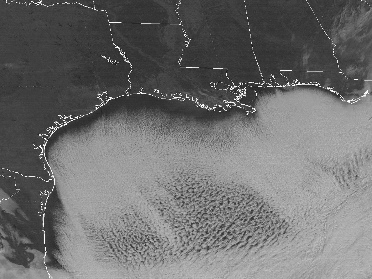
The large and very cold 1048 mb surface high over Texas slowly moved east over the region for the remainder of December 23rd. Despite the clear sunny skies, temperatures did not rise past the mid-20s for afternoon highs. With such a cold airmass moving over the warmer Gulf and Western Atlantic waters, cold air stratocumulus clouds prevailed just offshore the coastline over the entire Gulf and Western Atlantic, as shown by this GOES 7 Visible Satellite Image at 11:00 AM CST December 23rd. Also noteworthy was the significantly high sea level pressures across the area, which ended up setting all-time record high sea level pressure records at the primary climate sites as follows: Alexandria, LA at 1046.7 millibars (30.91 inches); Lake Charles, LA at 1046.7 millibars (30.91 inches); Lafayette, LA at 1044.4 millibars (30.84 inches); Beaumont, TX at 1047.9 millibars (30.94 inches).
As the surface high moved slowly overhead the night of December 23rd into the 24th, clear skies and calm winds allowed for morning lows in the mid to upper single digits to lower teens once again across the area. Temperatures finally rose above freezing briefly Christmas Eve afternoon, having remained below freezing between 62 and 68 hours across the area. With the cold surface high still overhead and slowly moderating, temperatures Christmas morning reached the upper teens to lower 20s across the area. Temperatures finally warmed up into the 50s by Christmas afternoon.
Due to the prolonged duration of temperatures below freezing and record cold temperatures, widespread frozen pipes burst in homes and businesses, causing severe water shortages across the area. Several fatalities were recorded across Louisiana and Texas, mainly to people with unheated homes. Widespread damage to the agricultural industry, particularly to the citrus and ornamental plants. Many freshwater and saltwater lakes and bays were completely frozen over with several inches of ice thickness. Even the near shore Gulf waters has a thin sheet of ice several miles off the beach. This caused massive fish and seafood kills, severely impacting the commercial and recreational fishing industry.
December 23, 1989 Record Low Temperatures
Compiled by: xmACIS2 |
 |
| STATE |
LOCATION |
STATION TYPE |
LOW |
| LA |
ALEXANDRIA |
COOP |
7 |
| LA |
ALEXANDRIA ESLER FIELD |
WBAN |
6 |
| LA |
BOYCE 3 WNW |
COOP |
7 |
| LA |
BUNKIE |
COOP |
8 |
| LA |
CROWLEY 2 NE |
COOP |
9 |
| LA |
DE RIDDER |
COOP |
7 |
| LA |
ELIZABETH |
COOP |
8 |
| LA |
EUNICE |
COOP |
9 |
| LA |
FRANKLIN 3 NW |
COOP |
10 |
| LA |
GRAND COTEAU |
COOP |
8 |
| LA |
HACKBERRY 8 SSW |
COOP |
12 |
| LA |
JEANERETTE 5 NW |
COOP |
10 |
| LA |
JENNINGS |
COOP |
10 |
| LA |
LAFAYETTE |
COOP |
9 |
| LA |
LAFAYETTE REGIONAL AIRPORT |
WBAN |
9 |
| LA |
LAKE CHARLES REGIONAL AIRPORT |
WBAN |
11 |
| LA |
LEESVILLE |
COOP |
6 |
| LA |
LELAND BOWMAN LOCK |
COOP |
11 |
| LA |
LSU DEAN LEE RESEARCH STATION |
COOP |
7 |
| LA |
MORGAN CITY |
COOP |
10 |
| LA |
NEW IBERIA |
COOP |
9 |
| LA |
OBERLIN FIRE TOWER |
COOP |
8 |
| LA |
ROCKEFELLER WILDLIFE REFUGE |
COOP |
10 |
| LA |
ROSEPINE RESEARCH STATION |
COOP |
6 |
| TX |
BEAUMONT RESEARCH CENTER |
COOP |
8 |
| TX |
ORANGE 9 N |
COOP |
10 |
| TX |
PORT ARTHUR SE TX REGIONAL AIRPORT |
WBAN |
12 |
| TX |
SAM RAYBURN DAM |
COOP |
7 |
| TX |
TOLEDO BEND DAM |
COOP |
7 |
| TX |
TOWN BLUFF DAM |
COOP |
6 |
| Consecutive hours below freezing |
| Location |
Start Date/Time |
End Date/Time |
Hours |
| Fort Polk, LA (KPOE-Army) |
12/21 - 7 PM |
12/24 - 2 PM |
67 |
| Alexandria Esler Field, LA (KESF-WBAN) |
12/21 - 6 PM |
12/24 - 2 PM |
68 |
| Lake Charles Regional Airport, LA (KLCH-NWS) |
12/21 - 11 PM |
12/24 - 1 PM |
62 |
| Lafayette, LA (KLFT-WBAN) |
12/21 - 11 PM |
12/24 - 2 PM |
63 |
| Port Arthur Southeast Texas Regional Airport, TX (KBPT-NWS) |
12/21 - 11 PM |
12/24 - 1 PM |
62 |
| *Alexandria Esler Field observations incomplete before 6 AM. |
Webpage design and content by: Donovan Landreneau
|


