|
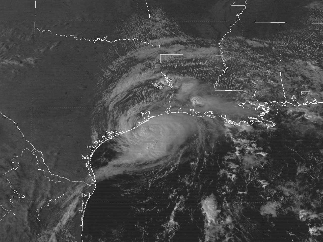
Above: GOES-7 visible satellite image of Hurricane Jerry just before landfall along the Upper Texas coast at 4:01 PM CDT October 15, 1989.
Jerry originated from a tropical wave that moved off the coast of Africa on September 23rd. The wave moved west across the Tropical Atlantic and the Caribbean Sea with no additional signs of development. The wave slowed down across the Western Caribbean by October 8th as it approached the Yucatán Peninsula. A broad area of low pressure developed over the Yucatán Peninsula the next couple of days. The low gradually became better organized as it emerged across the Bay of Campeche in the Southern Gulf on October 11th. By the early afternoon on October 12th, an Air Force reconnaissance aircraft confirmed that Tropical Depression #14 developed. Post storm analysis shows the depression likely developed around 7 AM CDT, and strengthened to Tropical Storm Jerry by 7 PM CDT.
A mid to upper level ridge of high pressure from the Eastern Gulf to the Atlantic, along with a broad mid to upper level trough over the Western Gulf, steered Tropical Storm Jerry on a north-northwest track around 5 to 10 mph through October 13th while slowly strengthening. By October 14th, the southern end of the mid to upper level trough cut off just west of Jerry across the Western Gulf. This feature caused Tropical Storm Jerry to jog to the northeast and slow down, as well as increased sheer temporarily halting development.
On October 15th, the mid to upper level cut off low moved further southward across the Southwest Gulf, along with the mid to upper level ridge over the Eastern Gulf building westward. This allowed Tropical Storm Jerry to resume the north-northwest movement at a faster pace, now 10 to 15 mph, and provided a more favorable environment for strengthening as Jerry reached hurricane status by 11 AM CDT. A GOES-7 visible satellite image at 4:01 PM CDT October 15th shows a small but well-developed Hurricane Jerry just off the Upper Texas Coast. Hurricane Jerry made landfall at 7:30 PM CDT near Jamaica Beach across the western end of Galveston Island with a peak intensity of 85 mph (75 knots) and a minimum sea level pressure of 983 millibars (29.03 inches). Hurricane Jerry became the second latest Texas landfalling hurricane on record, only behind a category two landfall between Brownsville and Corpus Christi back on October 16, 1912.
Jerry was downgraded to a tropical storm just north of Galveston Bay by 11 PM CDT October 15th. More rapid weakening commenced as Jerry moved further inland, with Jerry barely a tropical storm by 1 AM CDT October 16th, and a weakening tropical depression by 5 AM CDT just southeast of Lufkin, Texas. The weakening depression dissipated over the ArkLaTex later that afternoon as it merged with an unseasonably strong southward moving cold front that brought record low temperatures by October 19-20th across the region. Click here for an interactive track of Hurricane Jerry.
Three U.S. deaths were attributed to Hurricane Jerry, with all three within a vehicle that was either blown off or drove off the Galveston Seawall during the hurricane.
No significant wind damage was reported. Across coastal Jefferson County Texas, storm surge and high wave action caused beach erosion and damaged Texas State Highway 87 between High Island and Sabine Pass, and was closed once again. This section of the highway was damaged with Hurricane Chantal the beginning of August. Due to repeated bouts of damage from this season's hurricanes, as well as years past, along with the erosion of the coastline, the section of Highway 87 between High Island and McFaddin National Wildlife Refuge closed permanently. Due to the small size of Jerry, only minor beach erosion was noted across Western Cameron Parish in Southwest Louisiana.
WIND & PRESSURE:
Due to the very small size of Jerry, hurricane force winds were confined over Galveston Island and the Western Bolivar Peninsula. Tropical storm force winds likely occurred over Southwestern Jefferson County, but no observations were available there to confirm this. The strongest winds within our area occurred at Sea Rim State Park, Texas with a maximum sustained wind of 36 mph (31 knots) and a peak wind gust of 44 mph (38 knots) just after 11 PM CDT October 15th. Wind gusts of 20 to 30 mph were common across the remainder of Southeast Texas, Central and Southern Louisiana with the passing squalls. Further west, the highest sustained winds of 75 mph (65 knots) with a peak wind gust of 100 mph (87 knots) occurred at Galveston Scholes Airport at 7:34 PM CDT October 15th at the time of landfall. For complete meteorological statistics, see the Wind and Pressure section.
STORM SURGE:
Tides of 2 to 3 feet MSL were recorded along coastal Jefferson County in Southeast Texas and Cameron Parish in Southwest Louisiana. Higher tides of 6 to 7 feet MSL were recorded across Galveston Island and Eastern Galveston Bay. For other storm surge and high-water marks, see the Storm Surge section.
RAINFALL:
Due to the very small size of Jerry, the highest rainfall within our area was along and to the immediate right of the track where 3 to 6 inches fell. The highest rainfall total of 6.40 inches was recorded at Silsbee, Texas. Across the remainder of Southeast Texas, Central and Southern Louisiana, rainfall varied greatly with the passing squalls, ranging from less than a quarter inch up to 2 inches. For complete rainfall totals reported across our region, see the Rainfall section.
TORNADOES:
Several F0 tornadoes were reported across Galveston, Harris, Chambers, and Polk counties just west of our region. No deaths or injuries were reported with these tornadoes. For complete details on all the tornadoes reported across Texas and Louisiana, see the Tornadoes section.
|


