|
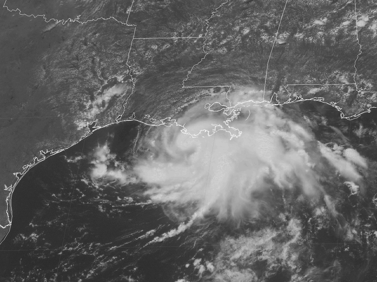
Above: GOES-8 visible satellite image of Tropical Storm Danny strengthening off the Southeast Louisiana Coast at 1:15 PM CDT July 17, 1997.
Danny originated from a non-tropical origin. On July 13th, a broad mid to upper-level trough of low pressure over the Southeast U.S. initiated a thunderstorm complex over Mississippi and Southeast Louisiana. Northerly flow aloft between a large mid to upper-level high pressure cell over the Western U.S. and the mid to upper-level trough over the Southeast U.S. steered the thunderstorm complex southward into the Northern Gulf. A weak surface low formed near the Southeast Louisiana coast on July 14th as the system moved into the Northern Gulf. The weak and disorganized low expanded somewhat through July 15th as it meandered off the Louisiana coast.
Deep convection and organization of the surface low continued during the overnight hours. By daybreak on July 16th, satellite estimates and observations from oil rigs and NOAA data buoys confirmed that Tropical Depression #4 had formed about 140 miles south of the coast of Southwest Louisiana. Only slow development continued for the remainder of the day as the depression now began to drift east northeast. By daybreak on July 17th, satellite and land-based radars, and data from an Air Force Reconnaissance Aircraft indicated that the depression intensified into Tropical Storm Danny. For the remainder of July 17th, Tropical Storm Danny strengthened at a faster rate as it moved east northeast towards the Southeast Louisiana Coast. A GOES-8 visible satellite image shows Tropical Storm Danny strengthening off the Southeast Louisiana Coast at 1:15 PM CDT July 17, 1997.
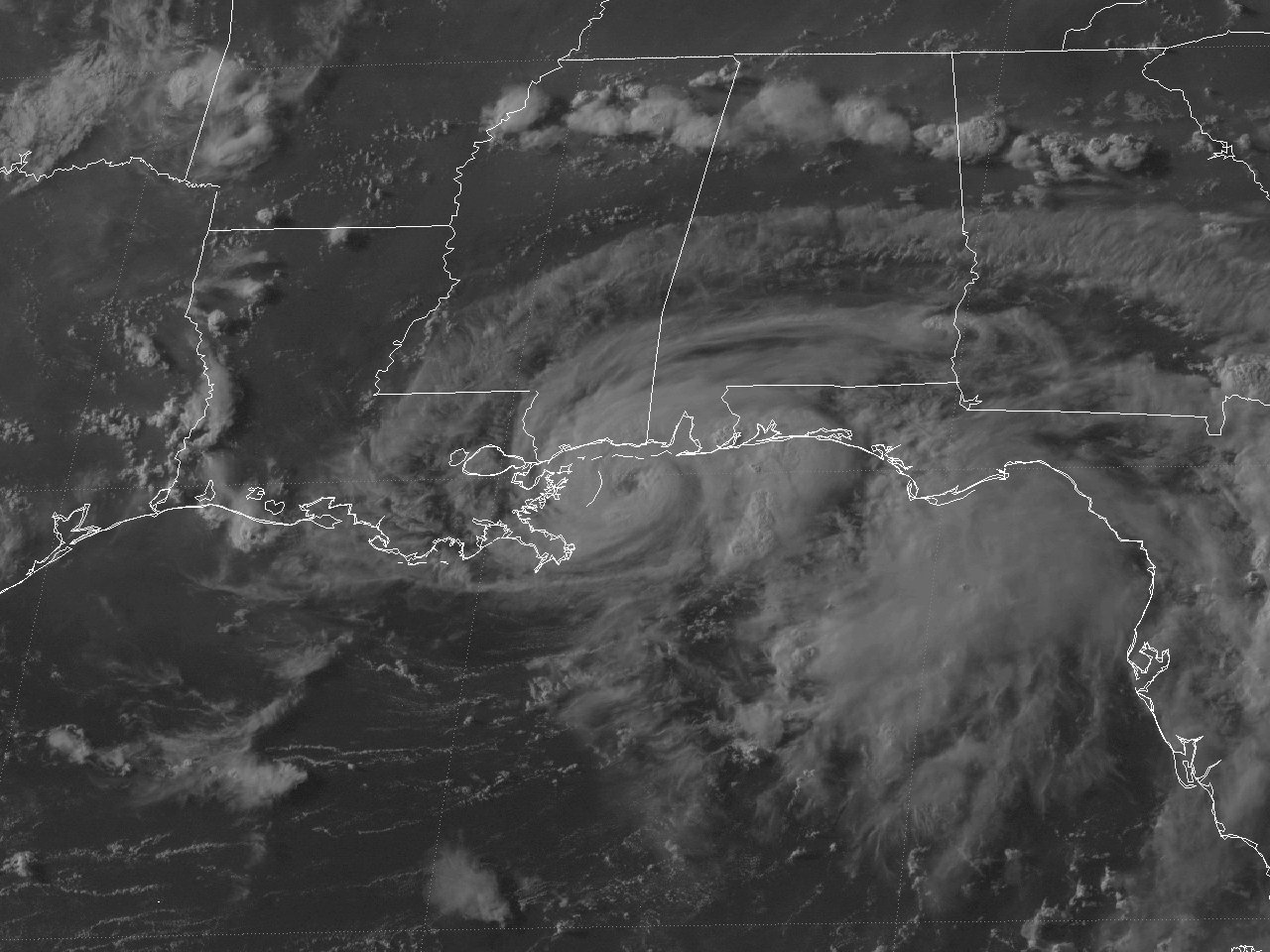
Danny reached minimum hurricane strength shortly after Midnight on July 18th just off the Southeast Louisiana Coast. Hurricane Danny made landfall near Empire and Buras, Louisiana at 4 AM CDT July 18th with maximum sustained winds of 75 mph (65 knots) and a minimum central pressure of 989 millibars (29.21 inches), as shown by the Slidell, LA WSR-88D radar image at 3:59 AM CDT July 18th. Since Plaquemines Parish is very narrow, basically comprising of the Mississippi River, the levee and some marshland on either side, the eye of Hurricane Danny was back over the Gulf an hour later. Hurricane Danny strengthened a little further, reaching a peak intensity of 80 mph (70 knots) and a minimum central pressure of 984 millibars (29.06 inches) about 40 miles south of the Mississippi and Alabama border. A GOES-8 visible satellite image at 6:02 PM CDT July 18th shows Hurricane Danny shortly before peak intensity. Hurricane Danny further slowed down and wobbled very slowly northeast, making the second landfall near Fort Morgan, Alabama at 5 AM CDT July 19th with maximum sustained winds of 80 mph (70 knots) and a minimum central pressure of 984 millibars (29.06 inches).
Very weak steering currents caused Hurricane Danny to basically meander across Southern Mobile Bay and come ashore just north of Gulf Shores by midday July 19th, and weakened back to a tropical storm shortly before sunset that evening. Further weakening continued as Tropical Storm Danny drifted north along the Alabama and Florida border during the overnight hours, weakening back to a Tropical Depression by midday on July 20th. Tropical Depression Danny continued a slow weakening, but retained a surface circulation for the remainder of its track across Alabama through July 22nd, and Northern Georgia and the Carolinas through July 24th. Now moving northeast at a faster rate, Tropical Depression Danny reattained tropical storm status as it exited the North Carolina Virginia coast midday on July 24th, eventually becoming extratropical early on July 26th off the Northeast U.S. coastline. Click here for an interactive track of Hurricane Danny.
WIND & PRESSURE:
No sustained winds of tropical storm force were recorded across Southeast Texas or Southern Louisiana. The highest sustained wind of 63 mph (55 knots) with a peak wind gust of 95 mph (83 knots) was recorded at Grand Isle, Louisiana at 3 AM CDT July 18th. For complete meteorological statistics, see the Wind and Pressure section.
STORM SURGE:
Tides of 2 feet MSL occurred across the Southwest Louisiana and Upper Texas coasts. Higher tides of 4 to 6 feet MSL occurred across Southeast Louisiana from Grand Isle to Venice, with a surge of 6.5 feet MSL recorded between Fort Morgan and Gulf Shores, Alabama. For other storm surge and high-water marks, see the Storm Surge section.
RAINFALL:
Most of the area missed the significant rainfall associated with Danny, with many locations not receiving any rainfall. Within the few locations that were affected by the northern rain bands associated with Danny, rainfall varied greatly from a few hundredths of an inch to over two inches. The highest rainfall total across our region was 2.74 inches at Port Arthur, Texas. Much higher rainfall was recorded near the point of landfall across South Alabama, with the highest total of 37.75 inches recorded at Dauphin Island, Alabama. For complete rainfall totals reported across our region, see the Rainfall section.
TORNADOES:
No tornadoes were reported across Louisiana.
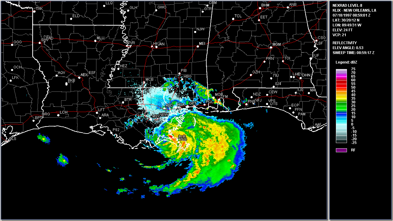
Above: Slidell, LA WSR-88D radar image of Hurricane Danny making the first landfall near Empire, Louisiana at 3:59 AM CDT July 18, 1997.
|


