Louisville, KY
Weather Forecast Office
Although this summer started off dry with drought conditions in the Blue Grass, we entered an active pattern by mid-June that lasted into early August. From June 25 to August 12 the region averaged a severe weather event every three and a half days. Storms brough torrential rains, large hail, strong winds, and a total of eleven tornadoes. The strongest twister was an EF-2 that struck Hardin County about three miles west of Cecilia on June 25.
The season ended up being slightly on the cool side for many locations. Louisville had its fewest 90 degrees days in the June-August period since 2009. Summer did end on a hot note, though, as a heat wave swept through the region August 21-26. Temperatures reached the 90s each day, culminating on the 25th with some locations approaching 100°. Dew points from the mid 70s to low 80s on the 25th led to heat index readings over 110°.
| Average Temperature | Departure from Normal | Precipitation | Departure from Normal | |
| Bowling Green | 77.2° | -0.9° | 13.70" | +1.04" |
| Frankfort | 73.9° | -1.8° | 12.45" | +0.27" |
| Lexington | 75.3° | +0.1° | 14.47" | +0.68" |
| Louisville Ali | 77.7° | -0.7° | 12.30" | +0.27" |
| Louisville Bowman | 74.9° | -2.3° | 11.61" | -1.16" |
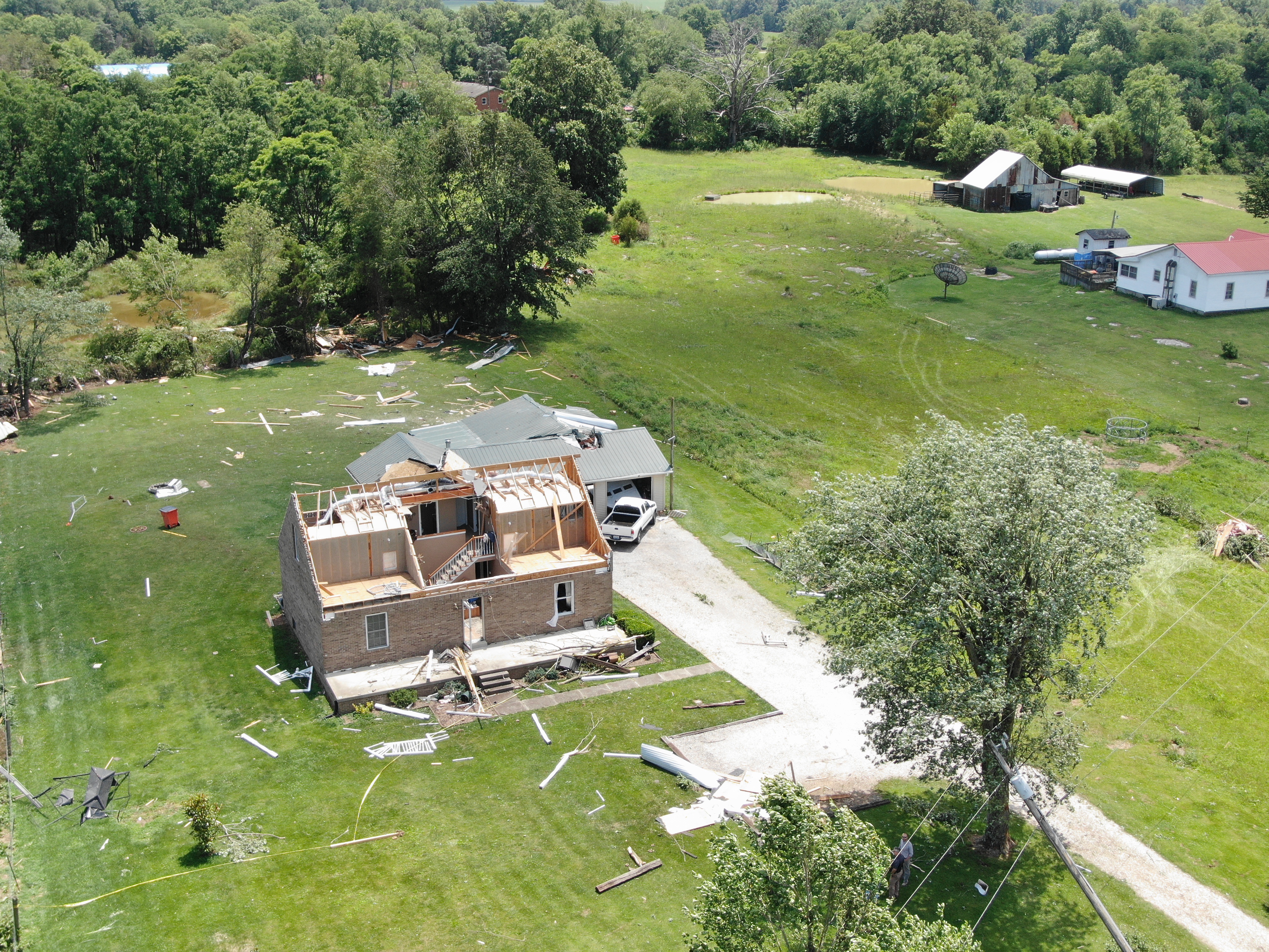
Tornado damage in Hardin County on June 25. NWS drone storm survey
Current Hazards
Hazardous Weather Outlook
Storm Prediction Center
Submit a Storm Report
Advisory/Warning Criteria
Radar
Fort Knox
Evansville
Fort Campbell
Nashville
Jackson
Wilmington
Latest Forecasts
El Nino and La Nina
Climate Prediction
Central U.S. Weather Stories
1-Stop Winter Forecast
Aviation
IDSS Forecast Points
Air Quality
Fire Weather
Recreation Forecasts
1-Stop Drought
Event Ready
1-Stop Severe Forecast
Past Weather
Climate Graphs
1-Stop Climate
CoCoRaHS
Local Climate Pages
Tornado History
Past Derby/Oaks/Thunder Weather
Football Weather
Local Information
About the NWS
Forecast Discussion
Items of Interest
Spotter Training
Regional Weather Map
Decision Support Page
Text Products
Science and Technology
Outreach
LMK Warning Area
About Our Office
Station History
Hazardous Weather Outlook
Local Climate Page
Tornado Machine Plans
Weather Enterprise Resources
US Dept of Commerce
National Oceanic and Atmospheric Administration
National Weather Service
Louisville, KY
6201 Theiler Lane
Louisville, KY 40229-1476
502-969-8842
Comments? Questions? Please Contact Us.


 Weather Story
 Weather Map
 Local Radar