| 1. Historic Ice Storm | |
| January 26-28, 2009 | |
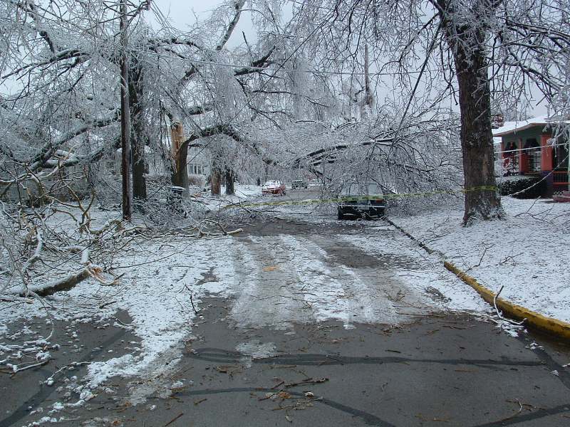
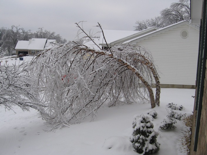 Trees straining under the weight of the ice in Louisville
|
|
|
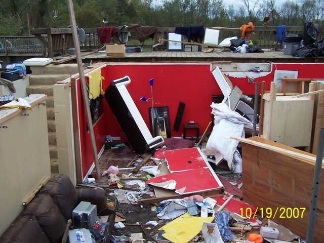
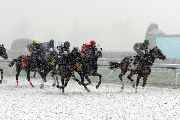
A wintry mix moved into southern Indiana and central Kentucky on the night of Monday, January 26, 2009. Precipitation began as light freezing drizzle and freezing rain over the entire area, but changed to sleet and then snow overnight into the early morning hours of Tuesday across southern Indiana and northern Kentucky. Up to 6 inches of snow accumulated across the northernmost sections of the CWA. Freezing rain continued over southern Kentucky. On Tuesday the 27th, precipitation changed to freezing rain over southern Indiana and northern Kentucky, and to rain over southern Kentucky. Ice over an inch thick was reported in many locations from the freezing rain. Tuesday night freezing rain and sleet continued over southern Indiana, freezing rain transitioned to rain over northern Kentucky, and rain, occasionally heavy, continued over southern Kentucky. Minor river flooding developed in some spots by Wednesday from the steady rain. On the morning of Wednesday, January 28, precipitation changed over to snow from northwest to southeast across the area. About 3 to 4 inches of additional snow accumulation piled up in the north, with less to the south. The storm caused Kentucky's largest power outage on record, with 609,000 homes and businesses without power across the state. Property damage was widespread, with the damage due to falling trees, large tree limbs, and power lines weighed down by ice. In the Louisville metropolitan area, 205,000 lost power and it took up to 10 days to get everyone hooked back up. Area school systems were closed for an entire week. Several emergency shelters were set up across the affected region. In Louisville's local school system, 69 schools lost power. Photo: Mark Schweitzer, NWS |
|
| 2. Super Tuesday Tornado Outbreak | |
| February 5-6, 2008 | |
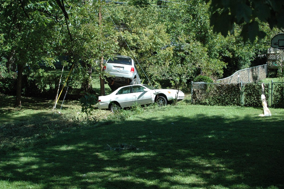
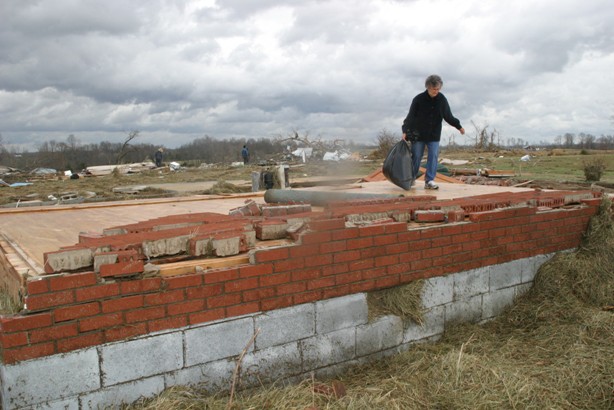 Home swept away by an EF3 tornado in Allen County |
|
|
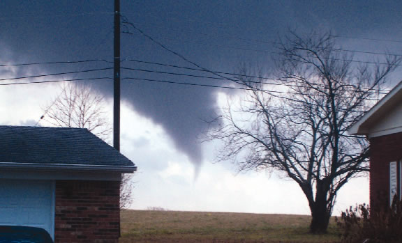
On the same day that 24 states were conducting primary voting for the 2008 presidential election, at least 84 tornadoes claimed 57 lives across the lower Ohio Valley and Southern United States. Much of the day was characterized by anomalously warm temperatures, with highs in many places across the South in the upper 70s to lower 80s, all ahead of a strong cold front. In Louisville, a high temperature of 68 was recorded at Standiford field on the 5th, with an early morning high of 67 on the 6th. The high temperature in Louisville on February 7, after the outbreak, was 36 degrees. Photo: Matt Pedigo, Allen County Citizen-Times |
|
3. Winter Storm
|
|
December 22-23, 2004
|
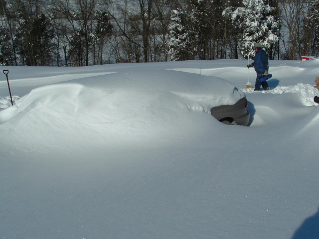 Milltown, Indiana
|
| During the 2004 snowstorm snow fell in southern Indiana at rates of as much as four inches per hour with storm totals as high as 32 inches and drifts to five feet. In Louisville, six inches of sleet combined with several inches of snow. Power was out for two days to 33,000 Louisvillians. Thundersnow and thundersleet were observed during the height of the storm. Farther south in central Kentucky, freezing rain deposited an inch of solid ice on all exposed outdoor objects, causing some roof collapses. Interstate 64 was closed for three full days. Interstate 65 was still down to just one passable lane in places on Christmas Day. The timing of the storm was unfortunate, occurring on some of the busiest travel days of the year, and stymieing last-minute Christmas shopping. Local businesses lost up to 80% of their expected sales during the storm. Photo: Angela Crecelius |
|
September 14, 2008
|
 A tree on a house in Louisville
|
| The remnants of Hurricane Ike, which had devastated the Galveston and Houston areas the day before, charged to the northeast through the Ohio and Mississippi valleys. Wind gusts to hurricane force were recorded as far north as southern Indiana. Countless trees were blown down across southern Indiana and western sections of central Kentucky. In the Louisville area, 301,000 people lost power, which was a new record for the city. 1400 power lines were torn down, hundreds of power poles snapped, and 130 roads blocked by debris. Some areas waited nearly two weeks for electricity to be restored, and some counties declared states of emergency. Four people were killed by falling trees and limbs. Photo: Mike Howard |
| 5. Hail, Tornadoes, Easter Freeze | |
| April 3-10, 2007 | |
|
|
Opening Day at Keeneland in Lexington April 6 |
|
After weeks of much warmer than normal temperatures, a powerful cold front brought severe storms to much of the region, bringing the balmy weather to an abrupt and dramatic end. The severe weather on April 3 ended an exceptionally warm three weeks that allowed trees and crops to bloom prematurely. Wind damage and hail were reported from many locations, and tornadoes swept across Taylor County and southern Casey County. The tornado in Casey County was rated as a high-end EF1, with top wind speeds of 105 mph. There were no injuries or fatalities. The path length was 13 miles long, with a width of 75 to 200 yards. The tornado skipped, with most damage on ridgetops. Touchdown was at 8:23pm EDT. The last ten days of March 2007 had been unusually warm, with high temperatures in the 70s and 80s each day. The cold front that passed through the region on April 3, which brought such extensive severe weather, also ushered in a massive dome of frigid Canadian air. From the 5th to the 10th of April temperatures dropped into the 20s and 30s each morning throughout the entire region. Bowling Green spent a total of 47 hours (non-consecutive) below freezing, bottoming out at 22 degrees on the 8th. Louisville fell to 25 on the 7th and Lexington dropped to 22 degrees on both the 7th and 8th. Hail Photo: Tom and Phyllis Atteberry |
|
| 6. Blue Grass Ice Storm |
| February 15-16, 2003 |
An icy neighborhood in Lexington
|
|
By late afternoon on February 15, a cold dreary rain changed to freezing rain as northeast winds brought in colder air from southern Ohio. Thus began the infamous Bluegrass Ice Storm of 2003. Freezing rain fell nearly continuously through the next morning as temperatures fell into the upper 20s. Hardest hit were the cities of Frankfort and Lexington, where ice accumulations were around 1 inch on exposed branches and sidewalks. One person was killed in Lawrenceburg when struck by a falling ice-covered tree limb. Countless trees were destroyed and many area residents lost power for up to a week. According to the Kentucky Public Services Commission, power was knocked out to 280,000 customers. Over 3000 power poles were destroyed and nearly 800 transformers needed to be replaced. The total cost to area utilities was about $47 million, with another $26 million used by local municipalities to clean up the damage. |
| 7. Widespread Flash Flooding |
|
September 22-23, 2006
|
After the waters receeded on Spring Drive in Elizabethtown
|
|
A slow-moving storm system brought torrential rains to the region on September 22 and 23, 2006, resulting in widespread flooding. Six people were killed in the Louisville NWS office's area of responsibility. It was the worst general flood since the March 1997 flood. It was the deadliest weather event in this area since seven people were killed in the flood of March 1-2, 1997, and the Super Outbreak of tornadoes on April 3, 1974 when 72 lives were lost. Six to nine inches of rain fell on the Ohio River counties of southern Indiana and northern Kentucky, including Louisville, and into the Frankfort and Lexington areas. Another area of torrential rain brought over seven inches of rainfall to Neslon County as well. Photo: Tom WIlliams, Station 50 Images |
| 8. Louisville Flash Flood |
|
August 4, 2009
|
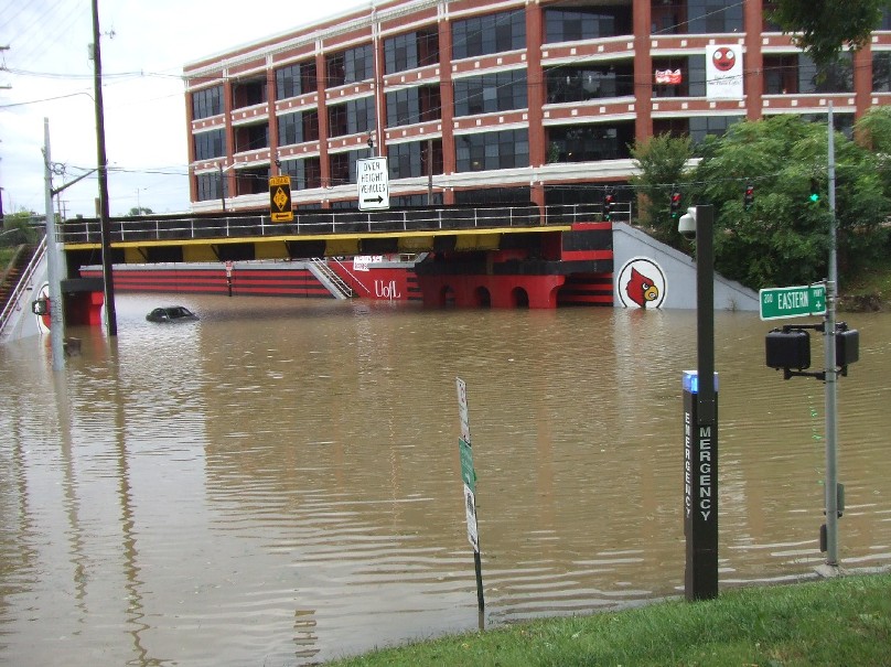 Disastrous flooding at the University of Louisville |
|
Record-breaking heavy rains fell in Jefferson County, Kentucky, as well as Floyd and Clark Counties in Indiana as strong thunderstorms regenerated over the area. Rainfall amounts up to 6 inches fell between 7am and 10am EDT, especially in central Louisville. Five inches of rain fell in 90 minutes from 7:45am to 9:15am, and rainfall rates up to an astounding 8.80 inches per hour were reported. There were no fatalities or injuries. A woman and two children were trapped and then rescued in New Albany. Ten kittens and a dog at the metro animal services shelter in Louisville drowned when the building flooded. In Louisville, nearly 200 people were rescued by emergency workers from the tops of cars and houses. About 50 people were rescued by boat from a University of Louisville administrative office building. Two children were pulled from a swollen creek when neighbors saw them get swept away as they walked too close to the stream. Water was reported up to several feet deep in parts of Louisville. Cars were submerged in a downtown parking lot. Major flooding affected Churchill Downs and surrounding neighborhoods. Interstates 65 and 264 were closed. Floodwaters poured into homes and engulfed Louisville's main public library downtown, several area hospitals, horse barns at Churchill Downs, and the University of Louisville campus. Thousands of books were destroyed at the Louisville downtown library, with a million dollars in damage. Other water rescues were also reported in New Albany as well as in Sellersburg. Massive flooding occurred in New Albany, where cars were set alfoat. Up to three feet of water was on the streets of Jeffersonville, stalling vehicles. Water entered homes and businesses in Lanesville. Officially at Standiford International Airport (SDF), 4.53 inches of rain fell, which broke the old record for highest rainfall in a single day in August (set back in 1879). Three inches of that rain fell in just one hour. Dozens of flood warnings and statements were issued by the Louisville office of the National Weather Service. The average time between the issuance of a flood warning and the beginning of flooding was 63 minutes. The weather office received e-mails from the public thanking the meteorologists for issuing the flood products in a timely manner to give people ample warning of the unfolding disaster. Below is a rainfall map constructed on the day of the flood. Note the amazing bullseye of torrential rainfall centered right over downtown Louisville and New Albany. Photo: Mike Howard |
| 9. Derecho! | |
|
July 13, 2004
|
|
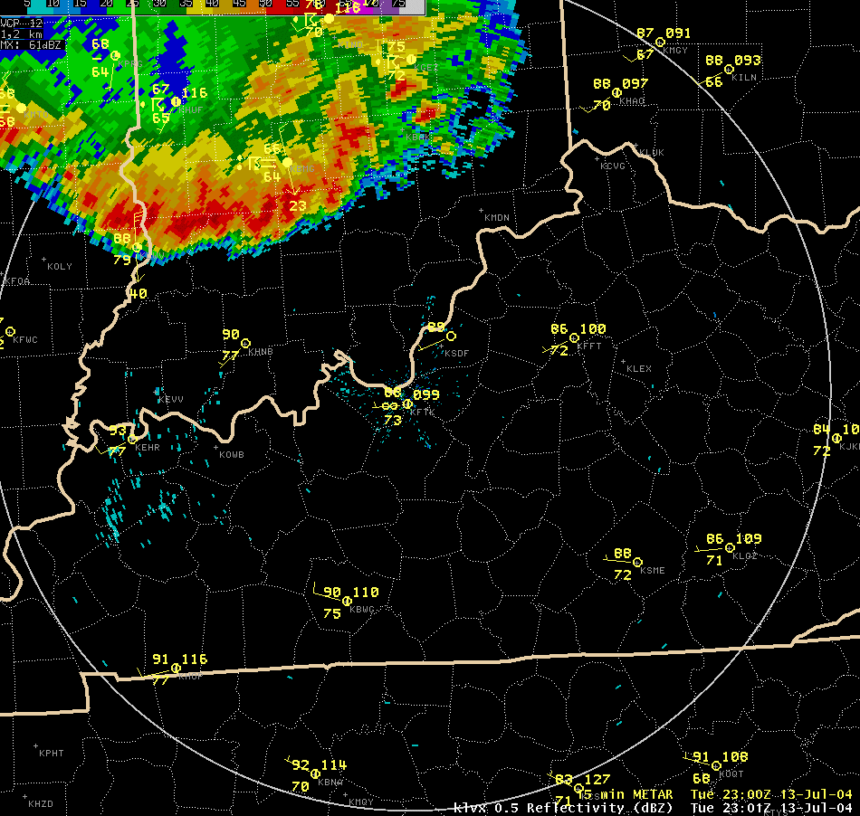 Radar loop of the squall line |
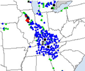
Storm reports. Red dots are tornadoes, blue are wind damage, and green are hail. |
|
The event brought widespread wind damage to almost every county across southern Indiana and central Kentucky. It all began as tornadic thunderstorms that developed in Illinois during the afternoon. The storms then organized into a derecho that dove south across the Ohio River during the evening hours. The line of storms had a length of almost 100 miles and a forward speed of 45 to 50 mph. Widespread destructive winds ranging from 60 to 80 mph accompanied the leading edge of the storms. A wind gust of 84 mph was measured by an anemometer in Bowling Green. Winds gusted up to 65 mph in Lexington. In Louisville, power was lost to over 100,000 homes. Officials at Louisville Gas and Electric mentioned that power outages were the most widespread since the tornado of April 3, 1974. During the overnight hours, scattered severe thunderstorms continued to develop within an unstable air mass, mainly producing large hail. |
|
| May 30, 2004 |
|
|
|
Five tornadoes raked across southern Indiana and the Louisville metro over a two hour period on the afternoon of May 30, 2004. The worst tornado was the first of the outbreak, causing F3 damage along parts of a 19 mile path across northern Crawford County. Near the end of its track, the twister took the life of a 70-year-old man in his trailer at Marengo. Witnesses reported multiple vortices with the tornado, which damaged 80% of Marengo. At about the same time, an F1 tornado struck Jeffersonville. The tornado crossed Interstate 65 between exits 1 and 2, and missed downtown Louisville by less than two miles. Photo: NWS |
| 11. Fall Tornado Outbreak | ||
| October 18 - 19, 2007 | ||
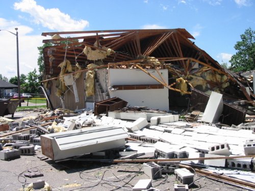
 House swept clean off its basement in Clark County |
||
| This family of 8 tornadoes that developed during the late afternoon of the 18th through the early morning hours on the 19th became the most prolific fall tornado outbreak ever recorded in Louisville’s forecast area. A tornado that touched down near Vesta in Clark County, Indiana was an EF-3. This tornado matched the strength of only a couple of other fall tornadoes ever recorded.
Photo: NWS |
||
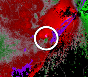
|
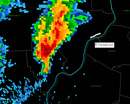
This storm, as seen on NWS radar, would go on to produce the F3 tornado in Clark County. The tornado's track is shown by the white line. Click on the image for a larger version. |
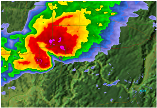
Above is a storm that produced an F2 tornado in Breckinridge County. The red and green colors next to each other show winds going in opposite directions. Click on the image for a larger version. |
|
| 12. Heat and Drought |
| August - October 2007 |
|
|
|
Drought had firmly established itself in the southeastern United States by late spring 2007, and began swelling northward during the early summer. By mid-June southern Kentucky had entered a severe drought with precipitation deficits since January 1 on the order of eight inches. The severe drought conditions continued to spread northward, and all of central Kentucky felt the effects by the end of June. Nelson and LaRue counties were the driest spots in central Kentucky during June, having received only 15% of their normal rainfall. The Commonwealth issued a Water Shortage Watch for 61 central Kentucky counties. Burn bans went into effect and the Green River Ferry in mammoth Cave National Park discontinued service because of low water levels. A few counties imposed water restrictions on residents. Scattered rains in July put a dent in the drought over much of central Kentucky, though the severe drought continued unabated over the south. Then came August. Searing heat baked Kentucky and southern Indiana, creating significant stress on agricultural concerns and water supplies. Temperatures soaring into the 90s nearly every day and over 100 degrees on several occasions, combined with continued low overall rainfall amounts, locked the region firmly in drought. By the third week of the month roughly the southern half of Kentucky had descended into extreme drought, with severe drought conditions crossing the Ohio River into southern Indiana. People from Logan County to Nelson County to Casey County were about sixteen inches below normal for rainfall since the beginning of the year. The Tennessee Valley Authority placed a fuel surcharge of $3 to $6 per month per customer on electricity. The number of wildfires in Kentucky increased 500% over the previous summer. In southern Kentucky soil moisture was about half of what it should have been, and 17 counties became eligible for Federal aid. The Barren River at Bowling Green was at its lowest point since teh Barren River Dam was erected in 1963. Nearly 30 temperature records were set in central Kentucky in August 2007, including 105 degrees at Louisville on the 16th which tied the all-time record for the month. Louisville set a new record for consecutive 90 degree days (22). August 2007 became the hottest month ever recorded at Louisville and Bowling Green, and the 3rd hottest on record at Lexington. Summer 2007 was the 2nd hottest summer on record in Louisville (one degree behind 1936), but the heat didn't stop with the change to autumn. Louisville recorded their 3rd hottest September, 2nd hottest October, and 2nd hottest autumn on record. Louisville set a new all-time high temperature for the month of October not once but twice, hitting 93 degrees on both the 7th and 8th. The amazing heat and drought were finally broken by a powerful cold front that brought widespread severe weather (see #12 in this list) on October 18. The Easter freeze (see #8) combined the with the terrible heat and drought of the summer and fall months made 2007 one of the most devastating years in the history of Kentucky agriculture. Photo: Greg Laramore |
|
13.Huge Hail
|
|
| May 1, 2002 | |
|
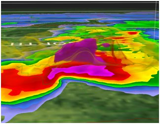
Radar view of the supercell, with the biggest hail in the area of the purple colors |
A 3-D image of the storm, showing the hail core colored purple in the center of the picture. |
|
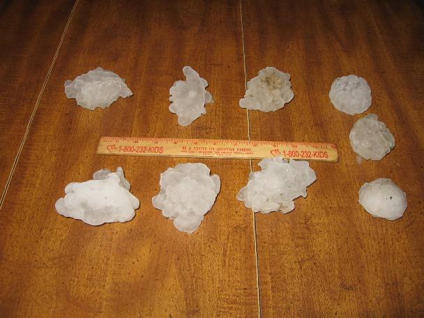
Number 13 on the list of the top 15 weather events of this decade brought perhaps the most widespread destructive hail from one storm since the Bowling Green hailstorm in 1998. Hail injured 3 people and caused an estimated $44 million in damage. The supercell developed during the late morning east of St Louis. It then tracked across southern Illinois and into southwestern Indiana during the early afternoon. It brought damaging golf-ball to softball sized hail from Dubois County all the way across central Kentucky through Casey County. Spotters reported softball-sized hail in Lincoln, Nelson, and Marion counties and baseball-sized hail in Larue County and Scott County, Indiana. Many communities sustained extensive roof and window damage from hail, including areas in Meade County near Doe Valley and Brandenburg. Large hail in southern IIndiana caused widespread damage to vehicles and structures in the Salem area. Baseball-sized hail was reported in Harrison County, while much of the hail across the rest of southern Indiana was around golf ball-size. Some trees and power lines were blown down by powerful thunderstorm winds, but the majority of the desrtuction was from hail. |
|
|
January 2, 2006
|
|
 A dramatic funnel cloud near Elizabethtown. |
|
|
The 14th most notable event this decade developed under an unseasonably moist and humid airmass on the second day of 2006. Although fall and early spring severe weather outbreaks occur regularly across the lower Ohio Valley, multiple tornadoes in the middle of winter are quite rare, especially in the Ohio Valley. Six tornadoes developed during the early afternoon, including three F-2s and three F-1s. Two people were injured and several million dollars worth of damage ensued. The Elizabethtown area was the hardest hit when an F2 tornado developed near Cecilia and headed northeast, crossing Dixie Highway about five miles north of downtown. Extensvie building damage was done along the crowded highway. A local school was about to let its students go home, but instead kept them in the building until the storm passed. Photo: Credit unknown |
| 15. Extreme Cold |
| December 2000 |
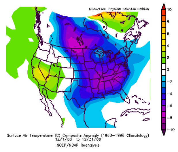 Temperature departure from normal for December 2000. Note the frigid air dumping into the Ohio and Tennessee valleys right out of Canada. |
|
The Midwestern region of the United States experienced its second coldest December in the 106 year record of observations. The December 2000 average temperature was 14.3°F, just missing the 1983 record of 13.9°F. A number of stations broke their all-time cold records for December, including South Bend, IN; Chicago-Midway, Rockford, and Moline, IL; and Louisville and Paducah, KY. The temperature departure pattern in December 2000 was similar to that in December 1983. The causes were similar, too. Both cold months occurred during a somewhat neutral to slightly La Niña oriented season, with central equatorial sea surface temperatures slightly cooler than normal. The resulting upper air patterns indicated the preference for a strong trough to develop over the central and eastern United States in both seasons. During December 2000, a strong ridge dominated the western coast of North America, helping to accentuate the north-south delivery of very cold air in the Midwest trough. While the amount of liquid water in the precipitation that fell during December 2000 was only slightly above normal overall in the Midwest, it is unusual for a cold month during winter to also be a month with normal or above normal precipitation. The remarkable aspect of the precipitation in December was that almost all of it was delivered in the form of snow, leading to a widespread deep snow pack that helped to maintain cold temperatures. Snowfall exceeded 300% of normal in the central and southern Midwest. While there were several major snowstorms that traversed the region during December, the sheer number of smaller "clipper" systems originating in the northern Rocky Mountains contributed greatly to the overall snowfall totals. The month ended up being the coldest December on record at Louisville and 2nd coldest at Lexington. It was Louisville's 3rd snowiest December on record with nearly an entire season's worth of snowfall occurring. Graphic and most text courtesy Midwest Regional Climate Center |


 Weather Story
 Weather Map
 Local Radar