
Scattered thunderstorms with severe gusts, hail and a tornado risk are possible near a cold front from the Ohio Valley to the Mid-Atlantic tonight. Tropical Storm Bertha is expected to bring tropical storm conditions to portions of the Gulf Coast from the panhandle of Florida into Louisiana through Wednesday. Read More >
| Cold air and the first snow of the season 24 October 2019 |
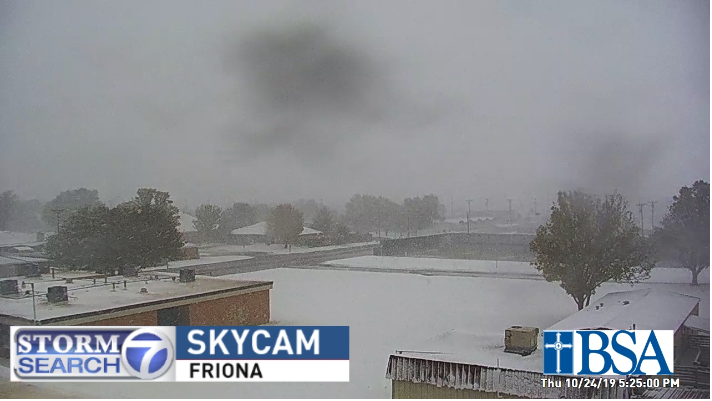 |
| Snow falling in Friona at 5:25 pm on Thursday, 24 October 2019. The image is courtesy of KVII. |
| A strong cold front and sharp upper level storm system conspired to bring the first taste of winter to the South Plains region on Thursday, October 24th. The cold front that supplied the much colder air moved through late Wednesday night, with sustained northerly winds of 20 to 30 mph continuing to carry in colder air all day Thursday. Temperatures fell from the 40s and 50s in the predawn hours to the upper 20s and lower to middle 30s by the later part of the day. |
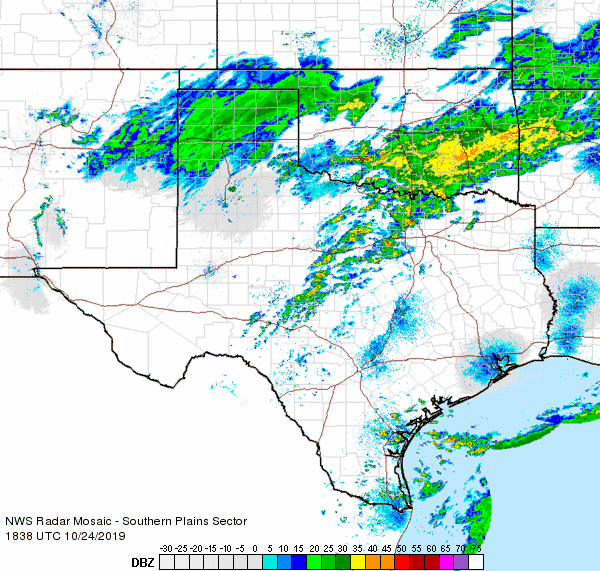 |
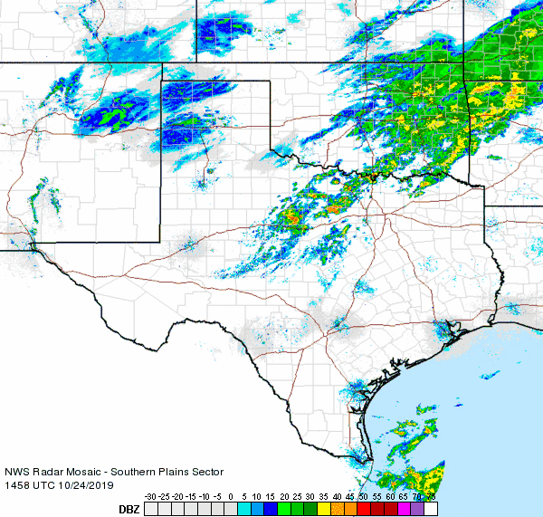
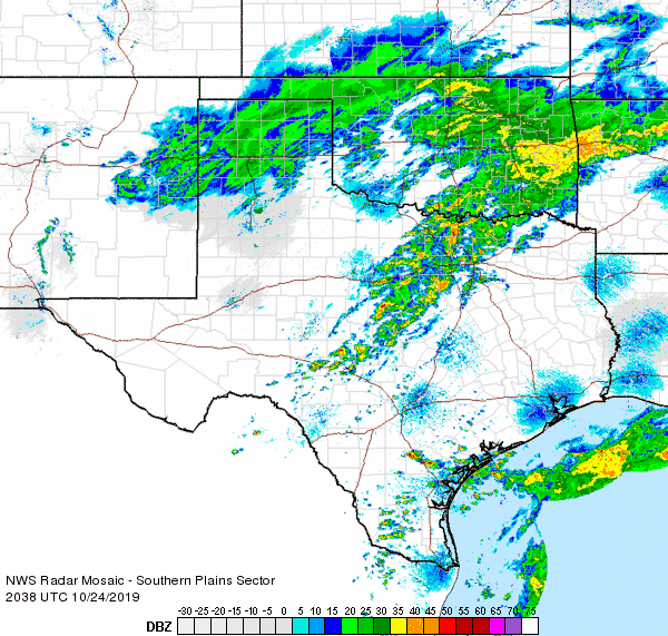
| Regional radar animation valid from 1:38 am to 2:48 am on 24 October 2019. Additional animations can be viewed at: 9:58 am to 11:08 am on 24 October 2019; 3:38 pm to 4:48 pm on 24 October 2019; and 5:08 pm to 6:18 pm on 24 October 2019. |
| In addition, precipitation blossomed over the Texas Panhandle as moisture was drawn up and over the colder air moving in, ahead of a storm system approaching out of the southern Rockies. In general, it was just cold enough for the precipitation to fall as snow, except on the far southern flank where rain and sleet briefly occurred. Early on, there was even enough instability that a number of locations across the Texas Panhandle experienced the relatively rare phenomenon of thundersnow. Further south, where the lift was weaker, drizzle and very light rain was more common through the day on the South Plains. |
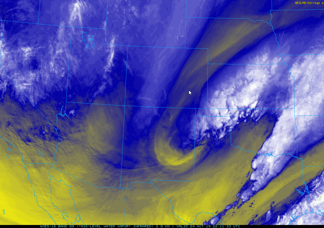 |
| Water vapor satellite image captured at 2:22 pm on 24 October 2019. An upper level disturbance is evident as it was approaching the Texas Panhandle |
| Temperatures continued to fall Thursday afternoon and evening, eventually dropping to and below freezing over much of the South Plains. This caused the drizzle to become freezing drizzle over portions of the northern and central South Plains. The snow and light icing did create some slick spots on area roadways. |
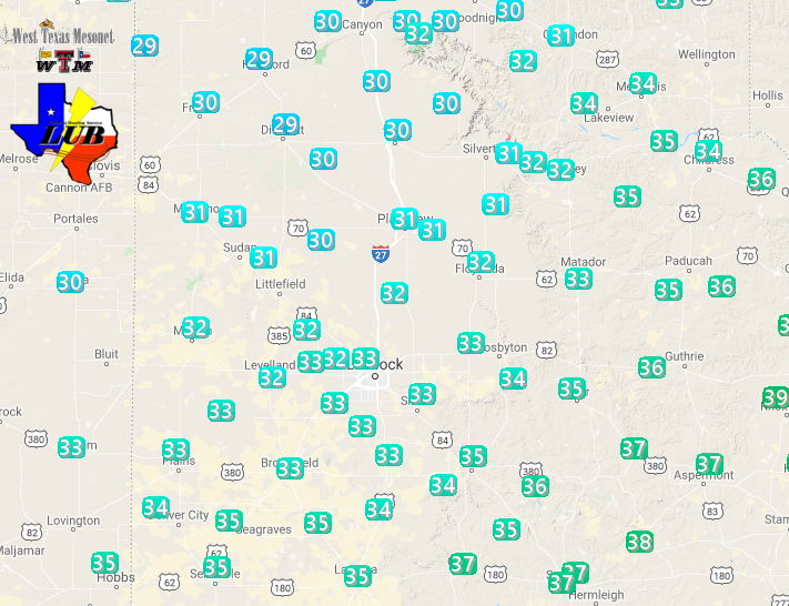 |
| West Texas Mesonet temperatures at 7 pm on 24 October. |
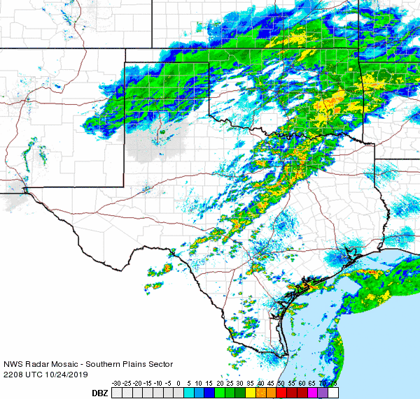
| Then, as the upper level storm system pivoted overhead, a narrow band of snow moved from west to east over the central and northern South Plains and southeast Texas Panhandle Thursday evening. Light snow even briefly fell in Lubbock, with a dusting observed in many spots. Officially, the Lubbock Airport recorded 0.1" of snow, making it the third earliest measurable snow on record, behind only October 17, 1999 (0.6" of snow fell) and October 21, 1911 (4.1" of snow fell). |
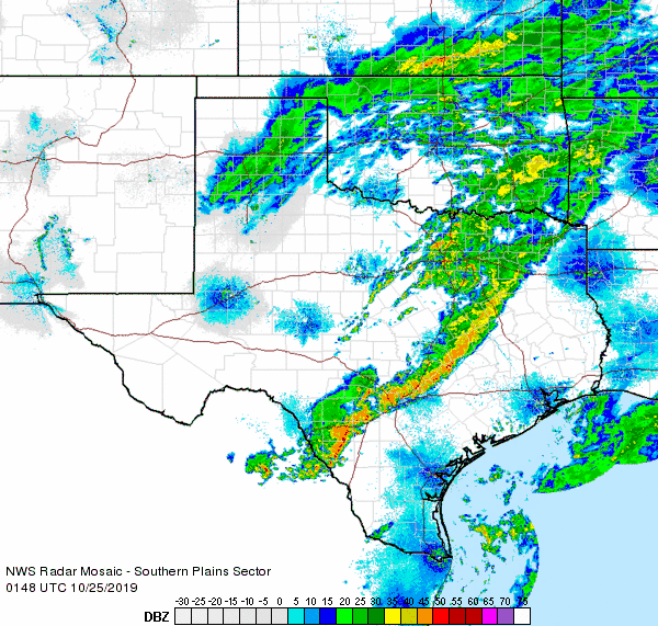 |
| Regional radar animation valid from 8:48 pm to 9:58 pm on 24 October 2019. |
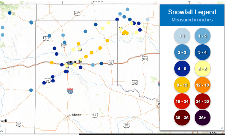
| The wintry precipitation quickly shifted off to the east by early Friday morning, leaving behind chilly temperatures and a swath of snow. The heaviest snow fell over the central and northeastern Texas Panhandle, roughly along the Highway 60 Corridor, where a half foot to nearly a foot of snow was measured. Further south, 1 to 3+ inches of snow was common over much of the southern Texas Panhandle into the northern South Plains. This included 4.5 inches in Friona and 11 miles north-northwest of Dimmitt and 3 inches just north of Dimmitt. |
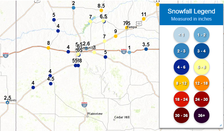 |
| Select plot of observed snowfall totals centered on the Texas Panhandle from 24-25 October 2019. A regional view of the same information can be VIEWED HERE. |
|
When skies cleared on Friday, the large fresh shield of snow was apparent on satellite imagery, stretching over much of the Texas Panhandle as well as parts of northeast New Mexico and southeast Colorado. The below image also clearly shows Palo Duro Canyon outlined by the heavier snowfall. |
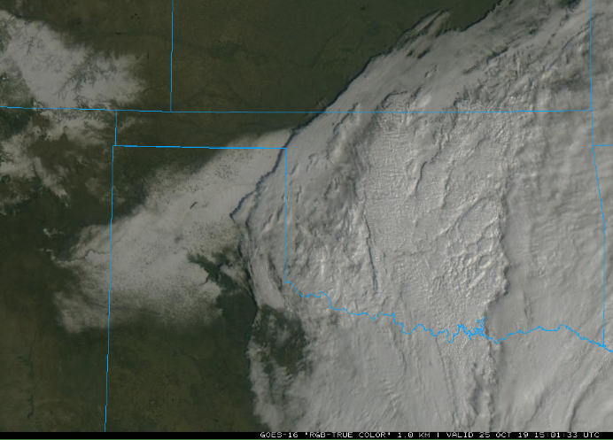 |
| Composite "True Color" satellite image captured at 10:01 am on 25 October 2019. The white represents clouds over much of Oklahoma, North Texas and the far eastern Texas Panhandle, but snow over the remainder of the Panhandles and northeast New Mexico. |
| A listing of snow reports gathered during the event, as well as standard daily reports collected the next day, can be found below. |
PRELIMINARY LOCAL STORM REPORT...SUMMARY
NATIONAL WEATHER SERVICE LUBBOCK TX
302 PM CDT FRI OCT 25 2019

..TIME...   ...EVENT...      ...CITY LOCATION...     ...LAT.LON...
..DATE...   ....MAG....      ..COUNTY LOCATION..ST.. ...SOURCE....
            ..REMARKS..

0616 PM     SNOW             FRIONA                  34.64N 102.72W
10/24/2019  M4.0 INCH        PARMER             TX   CO-OP OBSERVER

            2 FOOT DRIFTS

0823 PM     SNOW             11 NNW DIMMITT          34.70N 102.39W
10/24/2019  M4.5 INCH        CASTRO             TX   LAW ENFORCEMENT

            ON US-385 JUST SOUTH OF COUNTY LINE

0800 AM     SNOW             FRIONA                  34.64N 102.72W
10/25/2019  M4.5 INCH        PARMER             TX   CO-OP OBSERVER

0800 AM     SNOW             1 N DIMMITT             34.56N 102.32W
10/25/2019  M3.0 INCH        CASTRO             TX   CO-OP OBSERVER

0800 AM     SNOW             HART                    34.39N 102.11W
10/25/2019  M2.0 INCH        CASTRO             TX   CO-OP OBSERVER

0800 AM     SNOW             MULESHOE                34.23N 102.73W
10/25/2019  M2.0 INCH        BAILEY             TX   CO-OP OBSERVER

0800 AM     SNOW             OLTON                   34.18N 102.14W
10/25/2019  M1.0 INCH        LAMB               TX   CO-OP OBSERVER

0800 AM     SNOW             TULIA                   34.54N 101.77W
10/25/2019  M2.5 INCH        SWISHER            TX   CO-OP OBSERVER

0800 AM     SNOW             TURKEY                  34.39N 100.90W
10/25/2019  M1.0 INCH        HALL               TX   CO-OP OBSERVER

