
Dangerous heat will expand from the Gulf Coast into the Southern Plains and Desert Southwest through week's end. Additional extreme heat impacting the Pacific Northwest will shift to the northern Plains by the weekend. Tropical Storm Bertha is expected to continue to impact portions of the northern Gulf Coast from the western Florida Panhandle to southeastern Louisiana through tonight. Read More >
|
Storms bring heavy rain, wind and blowing dust |
|||||
 |
|||||
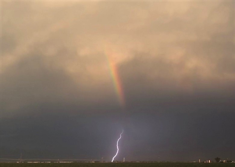
| Lightning and rainbow over Lynn County Sunday evening (28 August 2022). The image is courtesy of the West Texas Mesonet. | |||||
|
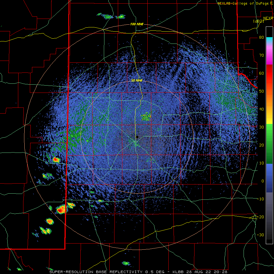
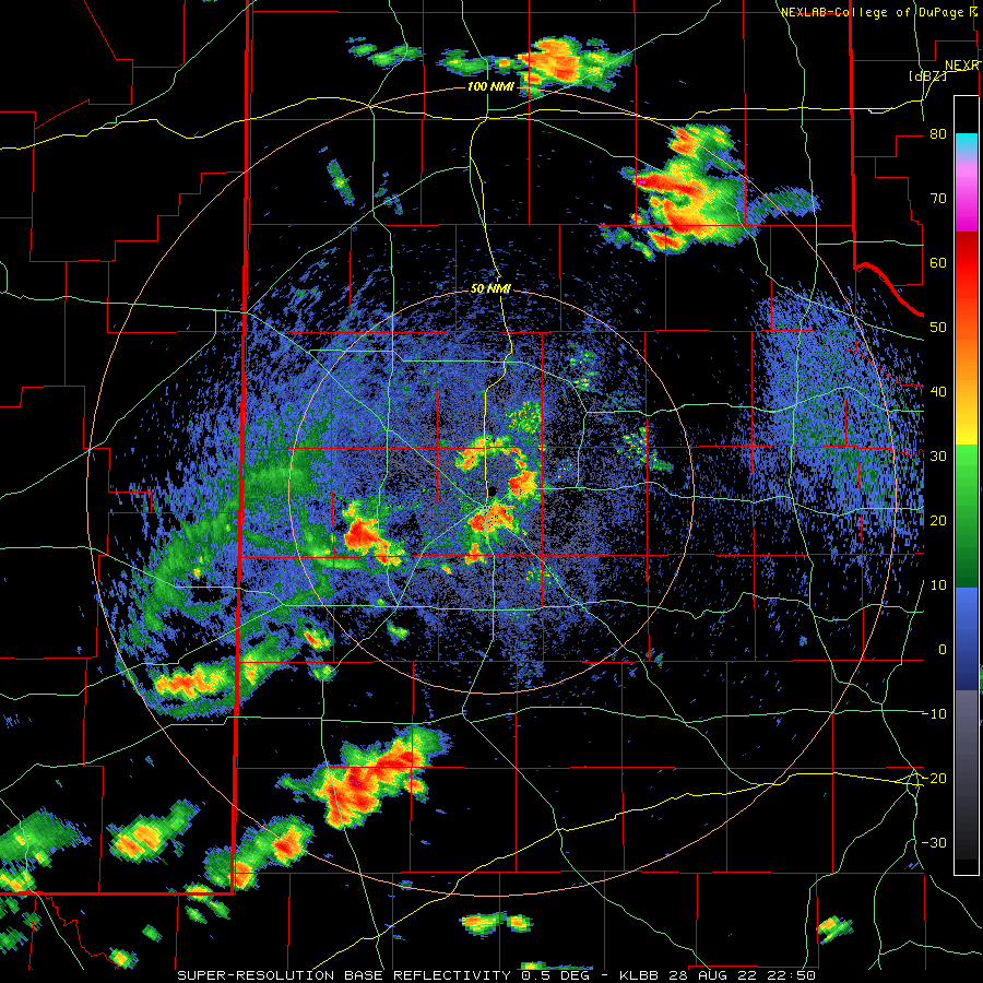
The end of August brought several rounds of thunderstorms to the South Plains region, beginning on the Sunday afternoon and evening (28 August). Hot temperatures, peaking in the 90s and lower triple digits, in combination with an influx of moisture, fueled widely scattered thunderstorm development Sunday afternoon. The storms that formed were particularly electric, producing proficient cloud to ground lightning, gusty winds and localized heavy rain. |
|||||
 |
|||||
|
|||||
|
One storm was particularly intense as it moved over Tahoka, dumping a load of rain and producing strong outflow winds. The lightning and wind knocked out power to many in and around Tahoka, while the quick 2 to 4 inches of rain that fell produced extensive street flooding. |
|||||
 |
|||||
|
|||||
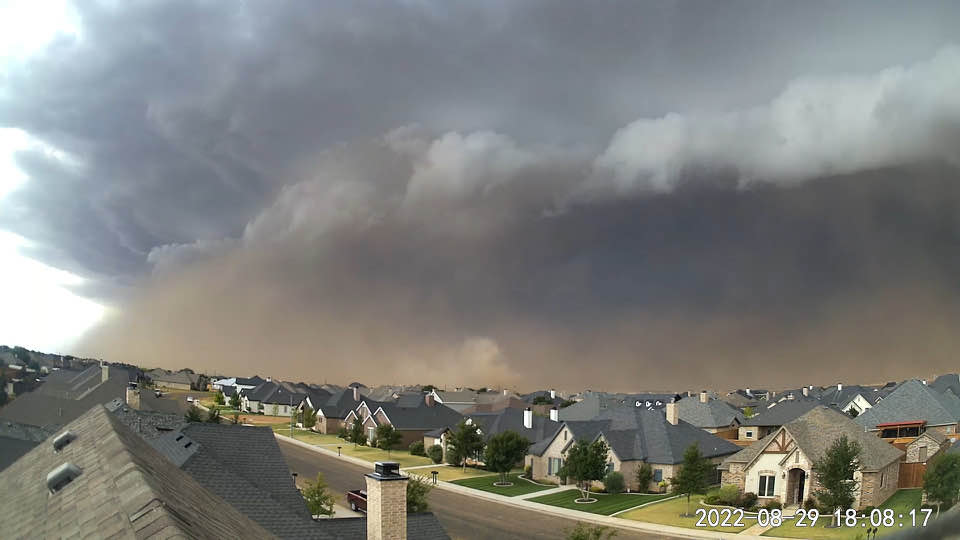
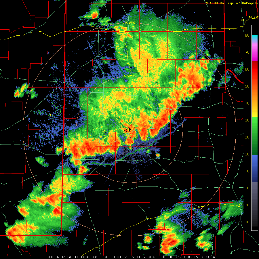
| The following day (Monday, 29 August) brought more widespread and intense thunderstorms, triggered in part by an upper level disturbance approached via the southern Rockies. Greater instability than the previous day led to rapid thunderstorm development Monday afternoon across the southwest Texas Panhandle and northwestern South Plains. This activity quickly grew into a line as it accelerated south and southeastward through the evening hours. Along the leading edge of the line, intense winds lofted a wall of dust (known as a haboob), dropping the visibility to near zero for a short time in many spots. Unfortunately, the haboob did contribute to several vehicle wrecks, including a two fatality accident near Roscoe, Texas. | |||||
 |
|||||
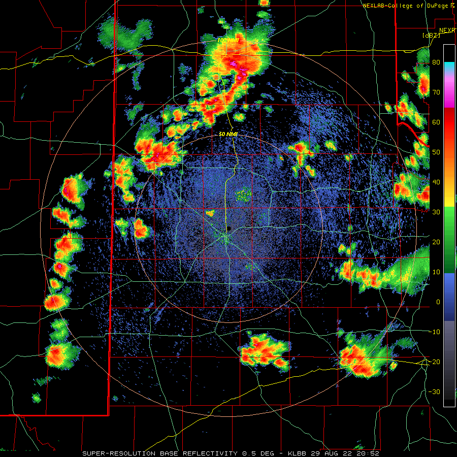
| Lubbock WSR-88D radar animation valid from 3:52 pm to 7:34 pm on 29 August 2022. An additional radar animation, valid from 6:54 pm to 9:38 pm, can be VIEWED HERE. | |||||
| The strongest wind gusts, from 45 to 60+ mph, swept southward across the Caprock through early Monday evening, before shifting down into the Permian Basin and Big Country. A peak wind gust of 73 mph was measured by the West Texas Mesonet site 6 miles south-southwest of Anton. Lagging the wind, many spots experienced a period of heavy rain, followed by prolonged light to moderate rain through the late evening hours. | |||||
 |
|||||
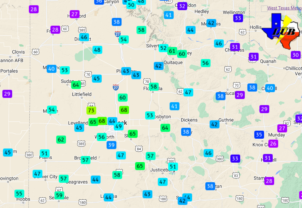
| Peak wind gusts recorded by the West Texas Mesonet on Monday, 29 August 2022. | |||||
| The already rich moisture levels continued to improve through the final two days of August, adding even more "fuel" for potential showers and thunderstorms. Indeed, this "fuel" was tapped by a slow-moving upper level low that took shape over Far West Texas, resulting in additional rounds of heavy rain. | |||||
 |
|||||
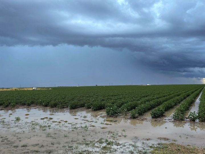
| Flooded cotton field near Ropesville on 30 August 2022. The picture is courtesy of the West Texas Mesonet. | |||||
| The showers and thunderstorms that developed on August 30th (Tuesday) were less intense than the previous day in terms of amounts of lightning and strength of the wind gusts they generated, but they did produce torrential downpours as they moved westward across the South Plains and Rolling Plains. The tropical-like downpours resulted in excessive runoff and created pockets of flooding Tuesday afternoon and evening before diminish after sunset. | |||||
 |
|||||
| Lubbock WSR-88D radar animation valid from 6:10 pm to 8:04 pm on 30 August 2022. | |||||
| The upper level storm system became nearly stationary, centered close to El Paso (see the below animation), which allowed extremely humid air to continue to be pumped up into West Texas on Wednesday (31 August). The near record moisture levels, along with the nearby upper level low and weak daytime heating, initiated another round of westward-moving showers and thunderstorms that dumped additional torrential rain in spots Wednesday afternoon. | |||||
 |
|||||
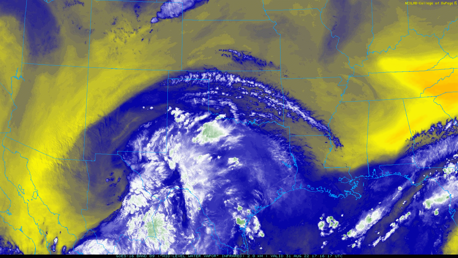
| Regional water vapor satellite loop valid from 12:16 pm to 1:11 pm on 31 August 2022. | |||||
| One relatively small shower that developed over Lubbock early Wednesday afternoon unloaded 0.50 to 1.50+ inches of rain in a matter of minutes, creating widespread street flooding. | |||||
 |
|||||
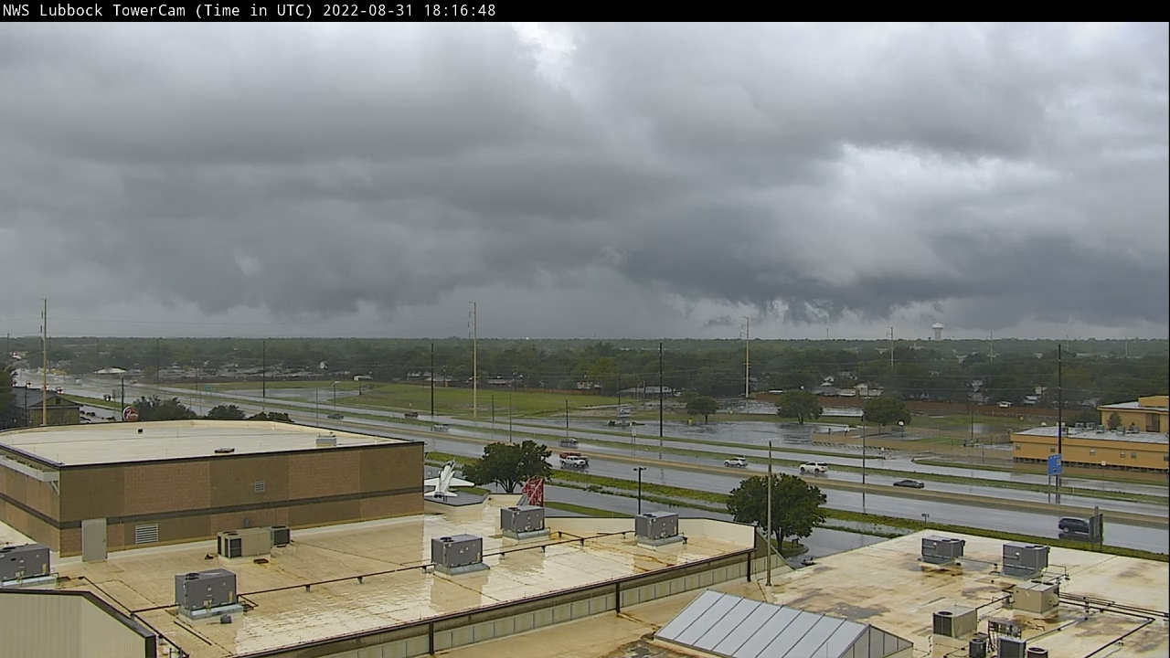
| Ominous clouds over Lubbock just after 1 pm on Wednesday afternoon (31 August). The shower dropped a quick inch or more of rain over parts of Lubbock in the matter of minutes. | |||||
| The torrential rain wasn't confined to Lubbock, but affected a good portion of the South Plains and Rolling Plains, with more isolated downpours across the southern Texas Panhandle. Instantaneous rainfall rates as high as 4-6+ inches an hour were common with the strongest cores. Thankfully, most of the activity moved steadily westward, but they were still able to 1 to 2+ inches in many spots before ending. | |||||
 |
|||||
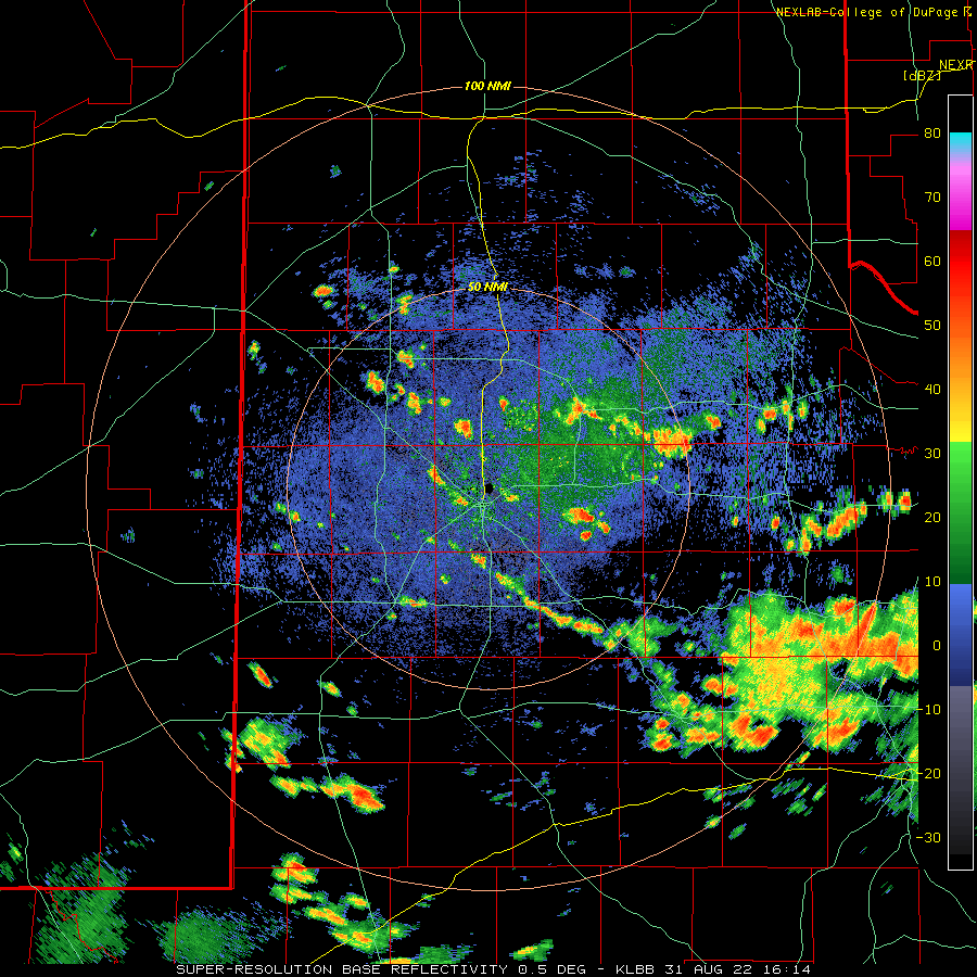
| Lubbock WSR-88D radar animation valid from 11:14 am to 12:54 pm on 31 August 2022. An additional radar animation, valid from 10:09 am to 5:36 pm, can be VIEWED HERE. | |||||
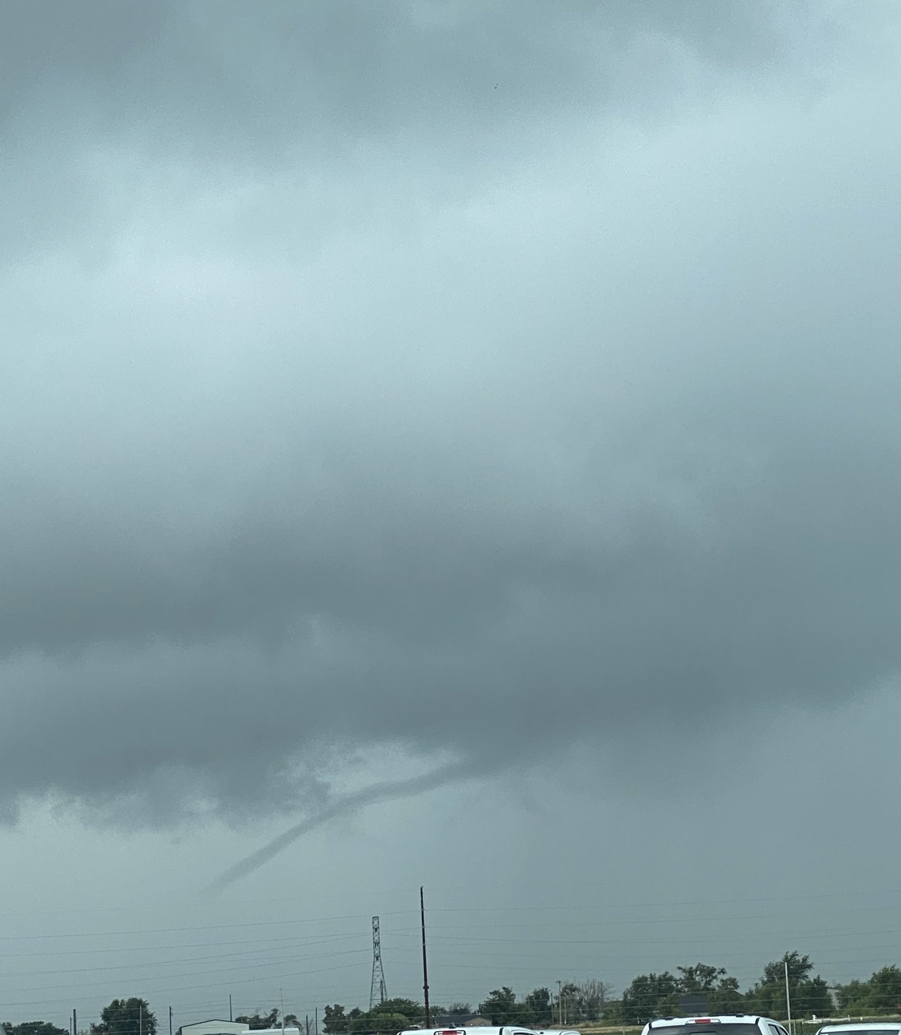
| In addition to causing flooding in and around Lubbock, Brownfield and Post, a couple of the tropical showers generated brief funnel clouds, as seen in the below image on the left. These "tropical-type funnels" did no known damage, but did further enhance the already ominous skies. | |||||
 |
 |
||||
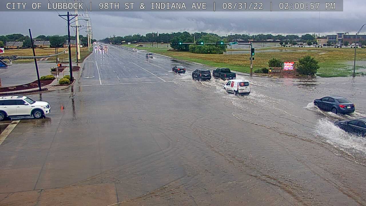
| (left) Funnel cloud near the southeast side of Lubbock around 1 pm on Wednesday (31 August). The picture is courtesy of Nick Alvarado. (right) Street flooding at the intersection of Indiana and 98th Street in south Lubbock Wednesday afternoon. The image is courtesy of the city of Lubbock. | |||||
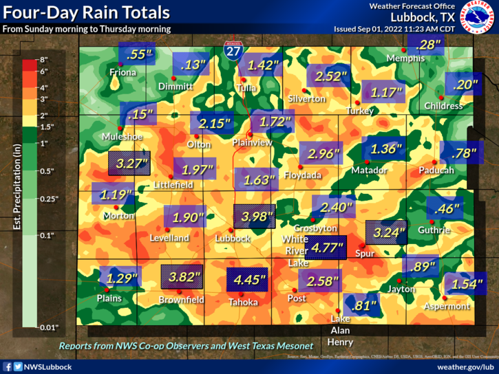
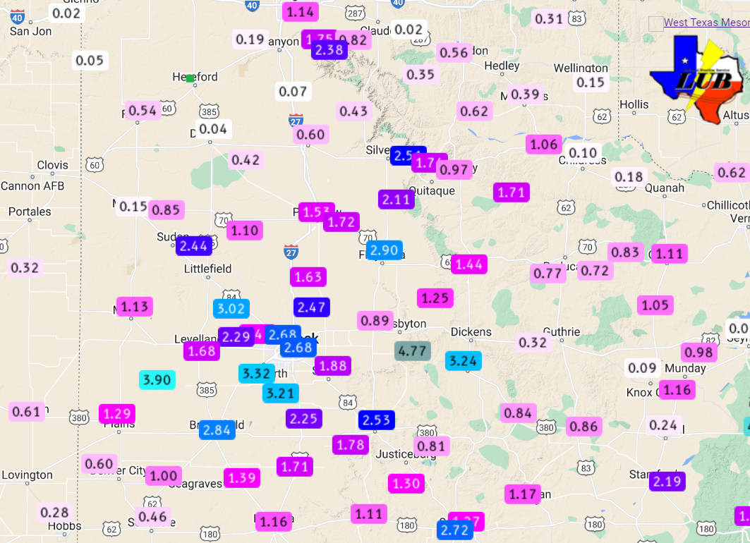
| The below map displays the measured rainfall over this wet late-August stretch. Rain totals of 1 to 3+ inches were common, except across the southeast and southwest Texas Panhandle and a few spots in the Rolling Plains, where rain was generally lighter. A number of locations across the South Plains into the western Rolling Plains recorded over 3 inches, including an impressive 4.45 inches in Tahoka and 4.77 inches at White River Lake. Although excessive at times, the rain helped mitigate the ongoing drought. | |||||
 |
|||||
| 4-day rainfall (inches) through Thursday morning (1 September 2022). The data are courtesy of the NWS COOP and the West Texas Mesonet (WTM). A display of all the WTM reports over this wet end to August can be VIEWED HERE. | |||||
|
Officially, the Lubbock Airport measured 3.57 inches over the unsettled end of August 2022, including a daily record rainfall of 2.25 inches on the 31st (breaking the previous record of 1.02 inches set in 1942). The rainfall boosted the year-to-date total to 10.86 inches, knocking the departure from normal below 2 inches for the first time in months. Preliminary storm reports collected during this unsettled late-August stretch can be found below: |
|||||
PRELIMINARY LOCAL STORM REPORT...SUMMARY
NATIONAL WEATHER SERVICE LUBBOCK TX
931 PM CDT MON AUG 29 2022

..TIME...   ...EVENT...      ...CITY LOCATION...     ...LAT.LON...
..DATE...   ....MAG....      ..COUNTY LOCATION..ST.. ...SOURCE....
            ..REMARKS..

0444 PM     TSTM WND GST     VIGO PARK               34.65N 101.50W
08/29/2022  M58 MPH          SWISHER            TX   MESONET

            WEST TEXAS MESONET

0504 PM     TSTM WND GST     1 NE AMHERST            34.02N 102.40W
08/29/2022  M64 MPH          LAMB               TX   MESONET

            WEST TEXAS MESONET

0545 PM     TSTM WND GST     CAPROCK CANYON SP       34.41N 101.06W
08/29/2022  M60 MPH          BRISCOE            TX   MESONET

            WEST TEXAS MESONET

0546 PM     TSTM WND GST     2 NNE FLOYDADA          34.00N 101.33W
08/29/2022  M58 MPH          FLOYD              TX   MESONET

            WEST TEXAS MESONET

0547 PM     TSTM WND GST     6 SSW ANTON             33.73N 102.19W
08/29/2022  M60 MPH          HOCKLEY            TX   MESONET

            WEST TEXAS MESONET

0550 PM     TSTM WND GST     2 WSW TURKEY            34.38N 100.93W
08/29/2022  M60 MPH          HALL               TX   MESONET

            WEST TEXAS MESONET

0552 PM     TSTM WND GST     6 SSW ANTON             33.73N 102.19W
08/29/2022  M73 MPH          HOCKLEY            TX   MESONET

            WEST TEXAS MESONET

0604 PM     TSTM WND GST     SMYER                   33.59N 102.17W
08/29/2022  M65 MPH          HOCKLEY            TX   MESONET

            WEST TEXAS MESONET

0610 PM     TSTM WND GST     REESE CENTER            33.61N 102.05W
08/29/2022  M68 MPH          LUBBOCK            TX   MESONET

            WEST TEXAS MESONET

0618 PM     TSTM WND GST     6 E NEW DEAL            33.73N 101.73W
08/29/2022  M68 MPH          LUBBOCK            TX   MESONET

            WEST TEXAS MESONET

0619 PM     TSTM WND GST     5 ENE ABERNATHY         33.88N 101.76W
08/29/2022  M59 MPH          HALE               TX   MESONET

            WEST TEXAS MESONET

0633 PM     TSTM WND GST     ROPESVILLE              33.41N 102.15W
08/29/2022  E60 MPH          HOCKLEY            TX   TRAINED SPOTTER

            REPORTED BY WEST TEXAS MESONET METEOROLOGIST

0648 PM     TSTM WND GST     2 NE SLATON             33.46N 101.62W
08/29/2022  M65 MPH          LUBBOCK            TX   MESONET

            WEST TEXAS MESONET

0649 PM     TSTM WND GST     8 WSW SUNDOWN           33.39N 102.61W
08/29/2022  M62 MPH          COCHRAN            TX   MESONET

            WEST TEXAS MESONET

0733 PM     TSTM WND GST     6 NW WHITE RIVER LAKE   33.53N 101.17W
08/29/2022  M64 MPH          CROSBY             TX   MESONET

            WEST TEXAS MESONET. EARLIER GUSTS TO 62 MPH AT 727 PM
            AND 60 MPH AT 728 PM.

0735 PM     TSTM WND GST     5 SSW GRAHAM            33.08N 101.52W
08/29/2022  M65 MPH          GARZA              TX   MESONET

            WEST TEXAS MESONET

0746 PM     TSTM WND GST     1 W O`DONNELL           32.97N 101.85W
08/29/2022  M58 MPH          LYNN               TX   MESONET

            WEST TEXAS MESONET

