|
Torrential rain and damaging winds |
|
 |
|
|
Supercell thunderstorm northwest of Lubbock Thursday evening (14 September 2023). The image is courtesy of Alex Schueth. |
|
|
Thursday evening and overnight (14-15 September) brought severe thunderstorms and torrential rainfall to portions of the South Plains, with an encore performance the following night. The thunderstorm activity was driven by plentiful moisture levels, sufficient instability and upper level disturbances passing over West Texas. |
|
 |
|
| Lubbock WSR-88D radar animation valid from 5:11 to 9:44 pm on Thursday (14 September 2023). | |
| Initially, the thunderstorms during Thursday evening were isolated to widely scattered. Sufficient vertical wind shear inspired some of the storms to rotate, becoming supercells, and tracking southeastward (as opposed to eastward, with the general steering flow). The most intense storm of the evening took shape across the southwest Texas Panhandle and tracked down Highway 84 all the way through Lubbock. This storm produced golf ball size hail in Earth, 60 mph winds near Amherst and wind damage in Anton. | |
 |
 |
| Wind damage from around Lubbock on Friday morning (15 September 2023). The left image is from near 4th Street and Slide Avenue, and is courtesy of Tim Sliwinski. The right image is from near 19th Street and Quaker Avenue, and is courtesy of Steve Divine. | |
| Following the evening supercell, a large complex of thunderstorm moved out of eastern New Mexico and across much of the South Plains and Rolling Plains through early Friday morning. | |
 |
|
| Lubbock WSR-88D radar animation valid from 12:51 to 4:48 am on Friday (15 September 2023). | |
| This large area of thunderstorms produced torrential rainfall as it moved through. In addition, it generated very intense winds as it approached and moved across Lubbock and Slaton. A peak gust of 78 mph was measured by the West Texas Mesonet site in Slaton at 3:14 am, shortly after the storms produced gusts of 55 to 69 mph in Lubbock. | |
 |
 |
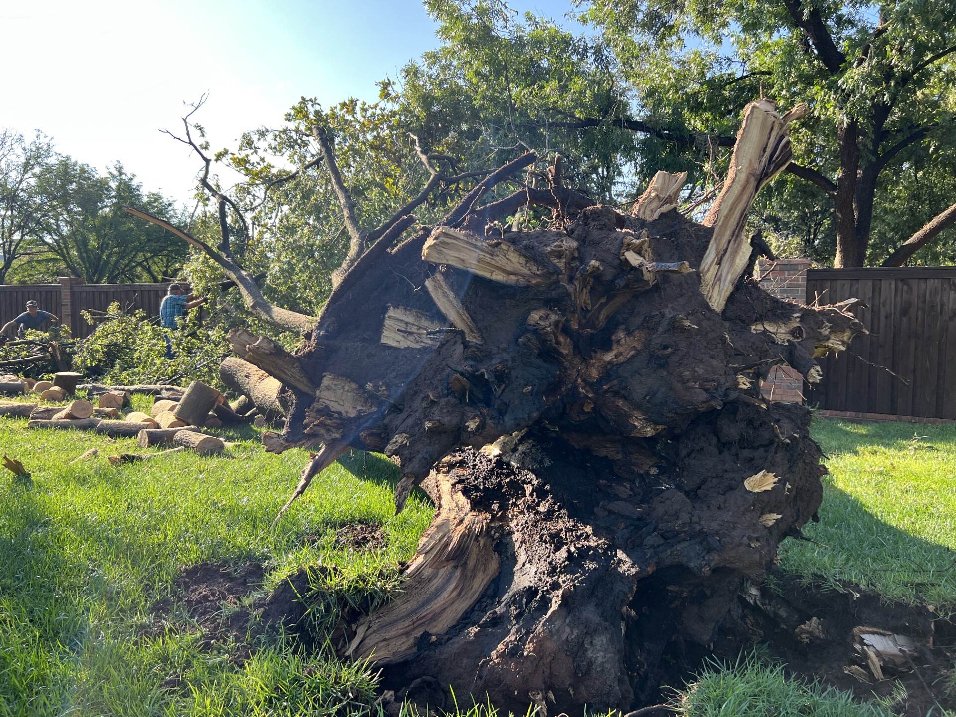
| Wind damage from around Lubbock on Friday morning (15 September 2023). The left image is from Stumpy Hamilton Park, and is courtesy of John Turpin. The right image is from Tech Terrace Park, and is courtesy of Wood Franklin. | |
|
The severe-caliber winds downed numerous large limbs and trees, and damaged several roofs in and around Lubbock as they raced through in the middle of the night. |
|
 |
|
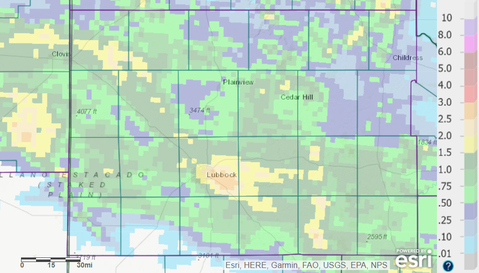
| 24-hour radar-estimated and bias-corrected rainfall ending at 7 am on 15 September 2023. Maps displaying observed rainfall measurements, courtesy of the West Texas Mesonet and NWS, can be FOUND HERE (South Plains view) and HERE (Lubbock close-up). The 7-day radar-estimated and bias-corrected rainfall ending at 7 am on 15 September 2023 can be VIEWED HERE. | |
| The heaviest rain from this event was also focused where the strongest wind occurred, from Lubbock through Slaton and southwest Crosby County. Rain totals of 2 to 3+ inches were measured over north and east portions of Lubbock down through Slaton. Impressively, much of the rain fell in less than a half hour, which led to extensive runoff and flooding. | |
 |
 |
| (left) Water flowing over FM 835 immediately upstream of Buffalo Springs Lake Friday morning (15 September 2023). (right) Water flowing over Comanche Drive on the west side of Buffalo Springs Lake Friday morning (15 September 2023). | |
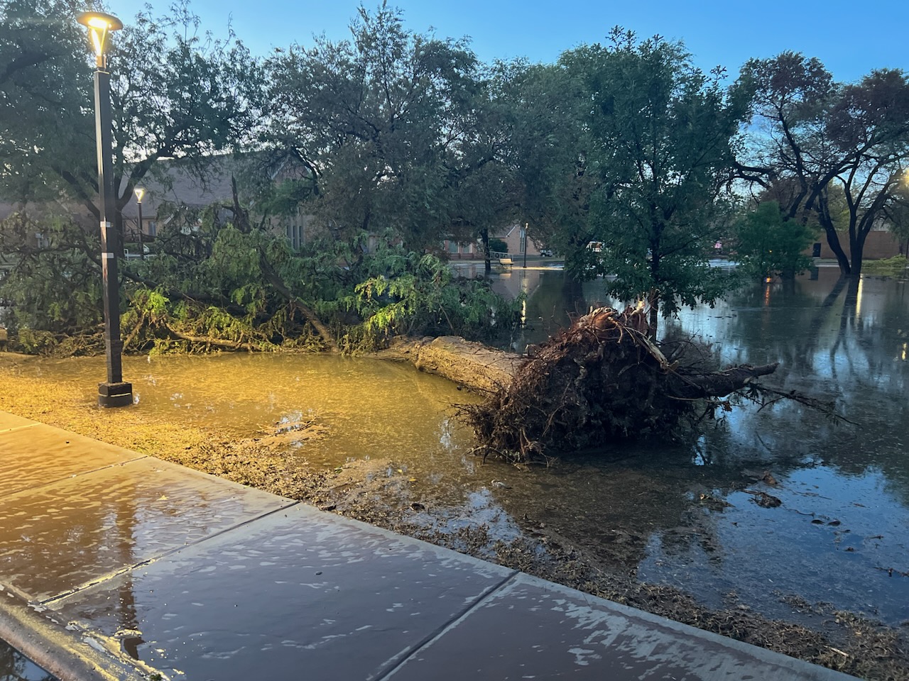
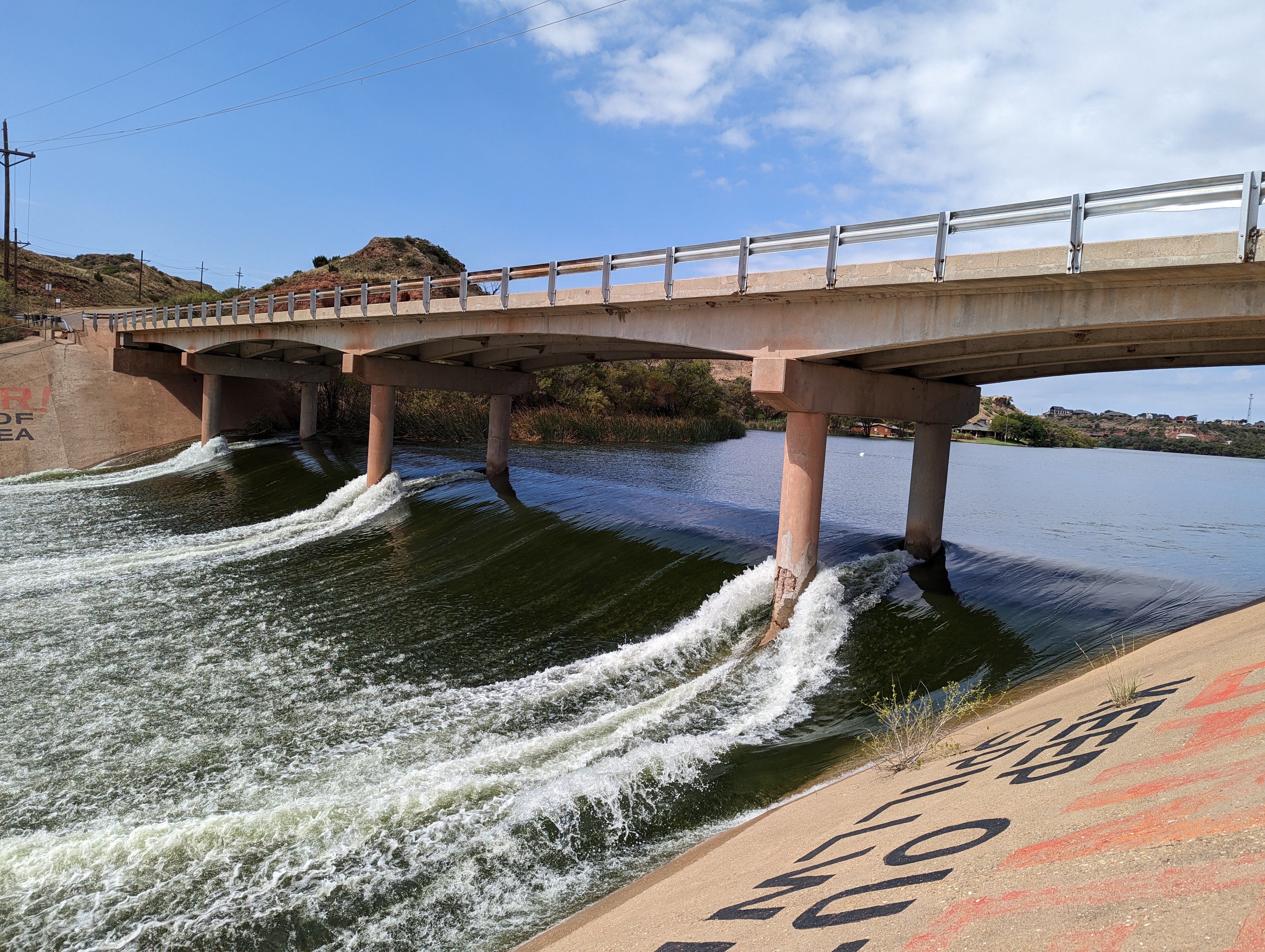
| The above and below pictures show the extent of the flooding observed Friday morning, as the runoff was directed down the North Fork of the Double Mountain Fork of the Brazos River downstream of Lubbock. | |
 |
 |
| (left) Water flowing over Buffalo Springs Dam Friday morning (15 September 2023). (right) Water flowing over Ransom Canyon Dam Friday morning (15 September 2023). | |
|
Even well after the rain concluded, many low spots and drainages were inundated with water, and several roads were closed. The below pictures show what can happen when trying to navigate through water-covered roadways. Thankfully, the driver was not injured when he left the roadway. |
|
 |
 |
| (left) Truck driving through a flooded roadway in Mackenzie Park in Lubbock Friday morning (15 September 2023). (right) The aftermath of attempting to drive through the flooded roadway. | |
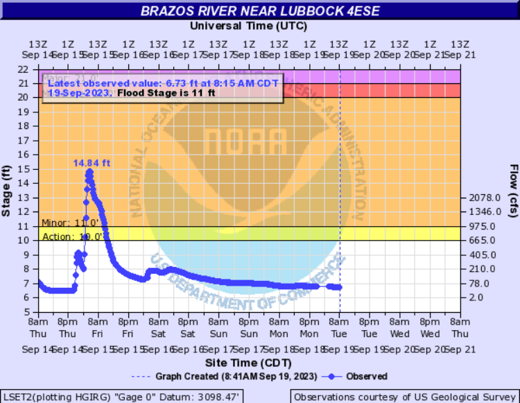
| The below graph illustrates the rapid rise on the Brazos River (measured on the southeast side of Lubbock) driven by the heavy rain early Friday morning. The river crested at 14.84 feet, with a peak flow of 4,270 CFS, at 5 am, before receding almost as quickly, falling below action stage before midday. This marked the highest level and flow since at least January 1, 2017. The peak flow took about 7 hours to reach Buffalo Springs Lake and Lake Ransom Canyon, about 5 miles downstream, where it aggravated the ongoing flooding. | |
 |
|
| Plot of the Brazos River near Lubbock 4ESE September 14th to 19th. The river crested at 14.84 feet early Friday morning (15 September). | |
| After a lull in activity through much of the day on Friday, another round of intense thunderstorms with heavy rain swept across parts of northwest Texas late Friday night into early Saturday. The strongest storms produced large hail and damaging winds. | |
 |
|
| Lubbock WSR-88D radar animation valid from 10:26 pm to 11:52 pm on Friday (15 Sep 2023). Additional radar animations can be found at: 8:58 pm to 10:53 pm on Friday (15 Sep); and 11:06 pm on Friday (15 Sep) to 9:22 am on Saturday (16 Sep 2023). | |
| Particularly hard hit were portions of Parmer County, several miles south, southeast and southwest of Friona, where baseball size hail was accompanied by severe winds that damaged 6 pivot irrigation sprinklers and a couple of dairy farms shortly after 11 pm. Unfortunately, 100+ head of cattle were lost as a result of the storm. Later that night a wind gust of 90 mph was measured by the West Texas Mesonet near McAdoo at 1:24 am, though no known damage was confirmed in or near McAdoo. | |
 |
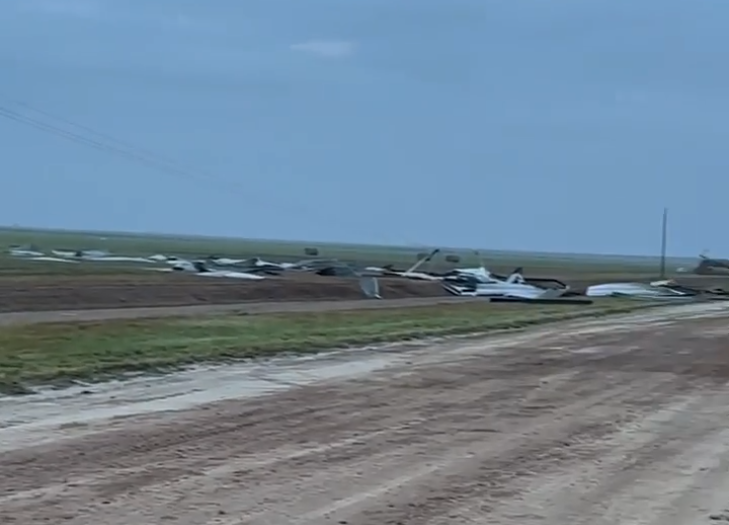 |
| Screen captures of damage incurred to a dairy farm about 8 miles south-southeast of Friona. The damage occurred Friday night (15 September 2023). The footage is courtesy of Hadley White. | |
|
Preliminary storm reports collected on September 14th, 15th and 16th can be found below: |
|
Preliminary Local Storm Report...Summary
National Weather Service Lubbock TX
1001 AM CDT Fri Sep 15 2023

..TIME...   ...EVENT...      ...CITY LOCATION...     ...LAT.LON...
..DATE...   ....MAG....      ..COUNTY LOCATION..ST.. ...SOURCE....
            ..REMARKS..

0745 PM     Hail             Earth                   34.23N 102.41W
09/14/2023  E1.75 inch       Lamb               TX   Public

            Media relayed public report of hail up to
            golf ball size. Mostly quarter to
            half-dollar size. Time estimated.

0849 PM     Tstm Wnd Gst     1 NE Amherst            34.02N 102.40W
09/14/2023  M60 MPH          Lamb               TX   Mesonet

            Measured by the West Texas Mesonet.

0928 PM     Tstm Wnd Dmg     Anton                   33.81N 102.16W
09/14/2023                   Hockley            TX   Public

            Roof blown off of outbuilding and into a
            nearby house. A fence supported by steel
            posts was also blown down and debris was
            found 200 yards away. Time estimated from
            radar.

0954 PM     Tstm Wnd Gst     4 NNE Shallowater       33.74N 101.97W
09/14/2023  M64 MPH          Lubbock            TX   Mesonet

            Measured by the West Texas Mesonet.

1015 PM     Tstm Wnd Gst     6 NNE Lubbock           33.67N 101.82W
09/14/2023  M61 MPH          Lubbock            TX   ASOS

            Measured by the Lubbock International
            Airport ASOS.

1017 PM     Tstm Wnd Gst     3 WNW Lubbock           33.60N 101.90W
09/14/2023  M66 MPH          Lubbock            TX   Mesonet

            Also gusted to 65 mph at 1018 PM. Measured
            by the Northwest Lubbock West Texas Mesonet
            site.

1025 PM     Tstm Wnd Dmg     2 NNW Texas Tech Univ.  33.61N 101.87W
09/14/2023                   Lubbock            TX   Law Enforcement

            Multiple power poles and lines downed.

0221 AM     Tstm Wnd Gst     2 NW Reese Center       33.61N 102.05W
09/15/2023  M66 MPH          Lubbock            TX   Mesonet

            Reese Center West Texas Mesonet site.
            Additional severe gusts ranging from 58 to
            64 mph measured from 219 AM through 227 AM.

0232 AM     Tstm Wnd Dmg     5 W Lubbock             33.58N 101.93W
09/15/2023                   Lubbock            TX   Broadcast Media

            Tree branches larger than one foot in
            diameter downed. Minor damage to homes also
            reported in the area of 19th and Chicago.
            Time estimated from radar.

0233 AM     Tstm Wnd Dmg     1 WSW Lubbock           33.57N 101.87W
09/15/2023                   Lubbock            TX   Emergency Mngr

            Several tree branches larger than 1 foot in
            diameter downed and several large mature
            trees completely uprooted. Time estimated
            from radar.

0234 AM     Tstm Wnd Dmg     2 SW Lubbock            33.56N 101.87W
09/15/2023                   Lubbock            TX   Emergency Mngr

            Tree down across road near 34th and
            University. Time estimated from radar.

0235 AM     Tstm Wnd Dmg     2 WSW Lubbock           33.57N 101.88W
09/15/2023                   Lubbock            TX   Emergency Mngr

            Corrected time. Multiple large tree branches
            larger than one foot in diameter downed just
            south of the Texas Tech campus. Time
            estimated from radar and nearby
            observations.

0236 AM     Tstm Wnd Dmg     4 SSW Lubbock           33.53N 101.88W
09/15/2023                   Lubbock            TX   NWS Employee

            Tree branch about one foot in diameter
            downed outside of NWS office. Time estimated
            from radar.

0237 AM     Tstm Wnd Gst     6 WSW Lubbock           33.57N 101.94W
09/15/2023  M59 MPH          Lubbock            TX   Mesonet

            Lubbock Christian University West Texas
            Mesonet site.

0238 AM     Tstm Wnd Dmg     5 W Lubbock             33.59N 101.92W
09/15/2023                   Lubbock            TX   Public

            Roofing material peeled off of low rise
            apartment building. Time estimated from
            radar.

0242 AM     Tstm Wnd Gst     6 SSW Lubbock           33.50N 101.88W
09/15/2023  M62 MPH          Lubbock            TX   Mesonet

            Corrected report. All Saints Episcopal
            School West Texas Mesonet site. Additional
            gusts to 59 mph measured at 241 AM and 243
            AM.

0247 AM     Tstm Wnd Gst     4 SSE Lubbock           33.54N 101.81W
09/15/2023  M69 MPH          Lubbock            TX   Mesonet

            Southeast Lubbock West Texas Mesonet site.
            Additional gust to 64 mph measured at 243
            AM.

0250 AM     Flash Flood      2 WSW Lubbock           33.58N 101.87W
09/15/2023                   Lubbock            TX   Public

            Several vehicles stalled out in high water
            at the intersection of 19th and University.

0314 AM     Tstm Wnd Gst     2 NE Slaton             33.46N 101.62W
09/15/2023  M78 MPH          Lubbock            TX   Mesonet

            Slaton West Texas Mesonet site. Additional
            gusts ranging from 58 mph to 70 mph measured
            from 303 AM to 316 AM.

0832 AM     Flood            1 E Lubbock             33.58N 101.83W
09/15/2023                   Lubbock            TX   Emergency Mngr

            E Broadway closed just south of Mackenzie
            Park with water over the roadway.

