|
Giant hail, heavy rain and strong winds impact the southwestern South Plains 29 May 2025 |
|
 |
|
|
Supercell thunderstorm near Brownfield Thursday evening (29 May 2025). The picture is courtesy of Lauren Baca. |
|
|
Thursday, May 29th, 2025, was a day of contrast for the South Plains region. The primary player on this day was a cold front, which started in the Texas Panhandle early in the day, but moved steadily south, even though the afternoon and evening hours. North of the cold front, low clouds and breezy northeasterly winds ushered in temperatures only in the 50s and 60s. However, south of the front, more sunshine and light southerly to easterly winds allowed temperatures to warm into the 80s. |
|
 |
|
| "RGB-True Color" satellite loop valid from 2:11 pm to 7:51 pm on Thursday (29 May 2025). An infrared satellite loop, valid from 2:01 pm to 8:41 pm on Thursday, can be VIEWED HERE. | |
| Despite minimal mid-upper level support, daytime heating and convergence along the southward moving cold front proved sufficient to trigger scattered thunderstorm development by mid-afternoon. Cold temperatures aloft, in combination with the warm and moist low-levels, resulted in strong instability that caused the storms to quickly intensify. In addition, veering and increasing winds with height induced some of the thunderstorms gain rotation. | |
 |
|
| Picture of a wall cloud west of Brownfield on Thursday evening (29 May 2025). The image is courtesy of Michael Brown. | |
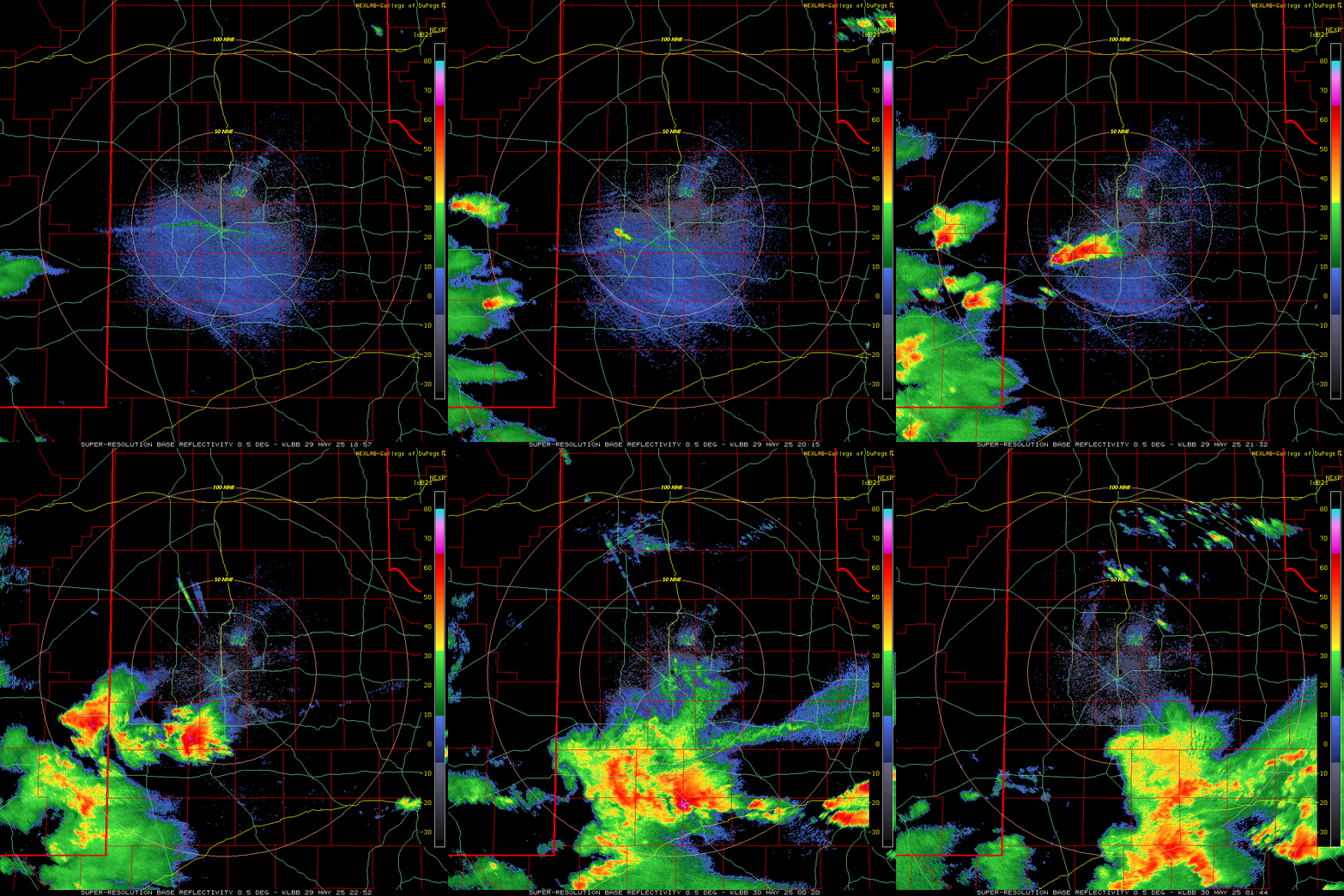
| The initial thunderstorm development over the South Plains occurred above Hockley County after 3 pm, with subsequent activity blossoming farther to the southwest from there. Early on, before the thunderstorms even matured, a couple of landspout tornadoes, akin to dust devils, occurred near Ropesville and Levelland. Thereafter, the activity quickly began to organize into a supercell (rotating) thunderstorm, while acquiring a south-southeasterly storm motion. | |
 |
|
| LBB WSR-88D radar animation valid from 1:57 pm to 8:44 pm on Thursday (29 May 2025). | |
| More specifically, three different thunderstorm cells gradually merged/morphed over central Lynn County, near Brownfield, into one well-organized supercell as it rode down FM 137 past Welch and Lamesa. | |
 |
|
| Multi-Radar Multi-Sensor (MRMS) 24-hr mid-level rotation track (1/sec) ending at 7 am on Friday (30 May 2025). | |
| The supercell storms quickly became proficient hail producers. A hail stone as large as 3.50 inches in diameter (close to softball size) was measured 6 miles north of Brownfield. | |
 |
 |
| Large hail that fell in and around Brownfield on Thursday evening (29 May 2025). The left picture was taken in Brownfield and is courtesy of Richard Rocha, relayed by Jacob Riley. The right picture was taken a few miles northwest of Brownfield during the ICECHIP (In-situ Collaborative Experiment for the Collection of Hail In the Plains) experiment. | |
|
Many other reports of ping pong to golf ball sized hail were received along the track of the thunderstorm as it moved southeast across Brownfield, Union and Punkin Center. A report of 3 inch diameter hail was received as far southeast as near Big Spring. |
|
 |
|
| Multi-Radar Multi-Sensor (MRMS) 24-hr maximum estimated hail size (mm) ending at 7 am on Friday (30 May 2025). | |
| On top of the hail and wind, torrential rain fell as the severe thunderstorm moved through. Thankfully, the storm did move quick enough to limit the duration of the hail and torrential rain. Even so, several locations measured around 1.50 inches of rain, most of which fell in the matter of tens of minutes. Runoff from the brief, but intense rain did cause some flooding issues, with several reports of flooding in and around Brownfield. | |
 |
|
| 24-hr radar-estimated and biased-corrected precipitation (inches) ending at 7 am on Friday (30 May 2025). A broader view of area can be FOUND HERE. Rainfall over this same period, measured by the WTM, can be VIEWED HERE. | |
| A list of the preliminary storm reports collected on May 29th can be found below. | |
Preliminary Local Storm Report...Summary
National Weather Service Lubbock TX
824 PM CDT Thu May 29 2025

..TIME...   ...EVENT...      ...CITY LOCATION...     ...LAT.LON...
..DATE...   ....MAG....      ..COUNTY LOCATION..ST.. ...SOURCE....
            ..REMARKS..

0315 PM     Landspout        2 SSW Levelland         33.56N 102.38W
05/29/2025                   Hockley            TX   Public

            Video of a landspout near Levelland,
            received via X. Location estimated.

0319 PM     Landspout        6 N Ropesville          33.50N 102.15W
05/29/2025                   Hockley            TX   Public

            Pictures of a landspout about 6 miles north
            of Ropesville, received via X. The landspout
            lasted from 3:10 to 3:19 pm.

0408 PM     Hail             8 NW Meadow             33.39N 102.34W
05/29/2025  E0.50 Inch       Hockley            TX   Public

            Report from mPING: Half-inch (0.50 in.).

0414 PM     Hail             2 NW Ropesville         33.43N 102.17W
05/29/2025  E1.00 Inch       Hockley            TX   Public

            Report from mPING: Quarter (1.00 in.).

0415 PM     Hail             2 NW Ropesville         33.43N 102.18W
05/29/2025  M1.50 Inch       Hockley            TX   Trained Spotter

            Corrects previous hail report from 2 NW
            Ropesville. Measured by the ICECHIP
            experiment.

0416 PM     Hail             2 NW Ropesville         33.43N 102.17W
05/29/2025  M1.50 Inch       Hockley            TX   Public

            Report from mPING: Ping Pong Ball (1.50
            in.).

0426 PM     Hail             2 W Ropesville          33.41N 102.19W
05/29/2025  E0.88 Inch       Hockley            TX   Public


0428 PM     Hail             2 W Ropesville          33.41N 102.19W
05/29/2025  E1.00 Inch       Hockley            TX   Public

            Reported by NWS Trained Weather Spotter.

0430 PM     Hail             6 NNW Ropesville        33.49N 102.19W
05/29/2025  E1.00 Inch       Hockley            TX   Trained Spotter

            Estimated largest hail of 1 inch diameter
            based on impacts. Most hail was 1/2 inch
            diameter. Time estimated from radar.

0454 PM     Hail             6 N Brownfield          33.27N 102.28W
05/29/2025  M3.25 Inch       Terry              TX   Public

            Report from mPING: Baseball+ (3.25 in.).

0502 PM     Hail             6 N Brownfield          33.27N 102.28W
05/29/2025  E3.50 Inch       Terry              TX   Public

            Report from mPING: Baseball++ (3.50 in.).

0510 PM     Hail             9 WNW Brownfield        33.24N 102.40W
05/29/2025  M2.50 Inch       Terry              TX   Trained Spotter

            Measured by the ICECHIP experiment well
            after it fell. Time of hail fall is
            estimated from radar.

0510 PM     Hail             Brownfield              33.18N 102.27W
05/29/2025  E1.50 Inch       Terry              TX   Public

            Picture of half dollar to ping pong ball
            sized hail in Brownfield. Relayed by media.
            Exact location is estimated.

0521 PM     Landspout        5 SW Brownfield         33.13N 102.34W
05/29/2025                   Terry              TX   Public

            Picture of landspout tornado near
            Brownfield. Location is estimated.

0523 PM     Flood            1 N Brownfield          33.19N 102.27W
05/29/2025                   Terry              TX   Public

            Report from mPING: River/Creek overflowing;
            Cropland/Yard/Basement Flooding.

0525 PM     Hail             Brownfield              33.18N 102.27W
05/29/2025  E0.75 Inch       Terry              TX   Public

            Hail estimated by ICECHIP experiment. Lots
            of pea to dime sized hail.

0538 PM     Hail             2 N Union               33.07N 102.23W
05/29/2025  E1.75 Inch       Terry              TX   Public

            Report from mPING: Golf Ball (1.75 in.).

0600 PM     Rain             2 S Brownfield          33.15N 102.27W
05/29/2025  M1.40 Inch       Terry              TX   Mesonet

            Heavy rain, much of which fell in 20 minutes
            between 5:20 and 5:40 PM. The data are
            courtesy of the West Texas Mesonet.