
Numerous severe storms with a potential for severe wind gusts, tornadoes (some potentially strong), and very large hail are expected in parts of the central and northern Plains. Heavy rainfall may bring a flooding threat to parts of the northern Plains and from the Ohio Valley to the Southeast. Fire weather concerns persist in the Four Corners Region. Hot and humid expected in the central U.S.. Read More >
Beginning on or about December 11th, 2019, the National Weather Service (NWS) Baltimore/Washington forecast office and the Middle Atlantic River Forecast Center (MARFC) in State College, Pennsylvania, will begin providing enhanced river forecast and warning services for portions of the Potomac River near Williamsport, Maryland, including most of Berkeley County, West Virginia.
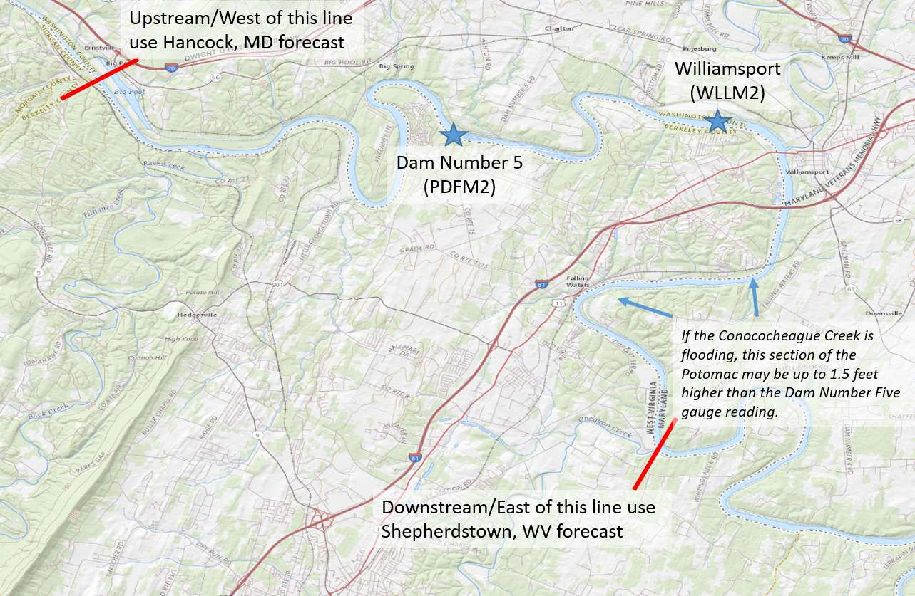
In 2018, the NWS installed a new real-time stream gauge at Dam Number 5 on the Potomac River near Marlowe, West Virginia, several miles upstream of Williamsport, Maryland. This new gauge, located on the downstream side of the dam, provides observations at least once per hour and has been shown to correlate well with both the existing Williamsport site, and with upstream data from Hancock, Maryland during high water situations.
Starting on or about December 11th, routine daily forecasts out to 72 hours in the future will be provided at Dam Number 5 by the NWS. Additionally, if flooding is anticipated in the area, Flood Watches or Flood Warnings will be issued. Geographically, this will cover the same reach areas as the Williamsport site (portions of the Potomac River banks within Berkeley County, West Virginia and Washington County, Maryland, between Big Pool and the mouth of Opequon Creek, as shown in the map below). Since the same geographic area is covered by both locations, separate watch and warning services at Williamsport will be discontinued on December 11th, 2019.
Flood stage will be set at 21 feet at the new location. This is lower than the current Williamsport flood stage, as surveys conducted by the National Weather Service show impacts occur at levels below the previous flood category. Other flood categories (action, moderate, major) will also be slightly lower than they were at Williamsport.
| Williamsport (old site) | Dam Number Five (new site) | |
|---|---|---|
| Action Stage | 15 feet | 14 feet |
| Minor Flood | 23 feet | 21 feet |
| Moderate Flood | 25 feet | 24 feet |
| Major Flood | 28 feet | 27 feet |
Some (approximate) impacts based on NWS surveys within this area include:
14 feet - portions of the C&O Canal start to flood west of Williamsport
14 feet - the Four Locks parking lot along the C&O Canal starts to flood
18 feet - water begins to come over bank in low-lying portions of the River Bend RV Community but little is affected
20 feet - water begins to cover the private drive leading to Dam 5; the entire Four Locks parking lot is flooded along the C&O
21 feet - water reaches non-permanent structures in the River Bend RV Community, including RVs and outbuildings
22 feet - water reaches the gate of the boat ramp at River Bend and starts to come overbank in a larger area; backwater approaches the parking area at Cushwa
23 feet - lower portions of the Potomac Fish & Game Club begin to flood
24 feet - water reaches the first floor of the powerhouse at Dam 5 with relatively widespread flooding in River Bend
25 feet - Structures begin to flood at the Potomac Fish & Game Club
27 feet - Widespread flooding is going on at River Bend and Potomac Fish & Game. Three feet of water in the powerhouse at Dam 5. Water approaching outbuildings at the Cushwa Basin.
29 feet - The vast majority of the C&O Towpath is under water.
31 feet - Water enters the Williamsport Cushwa visitor center.
At higher water levels, the river level at Dam Number Five is essentially equivalent to the existing Williamsport reading, so impacts you have observed in the past at a certain level at Williamsport should be similar based on the new location.
The current forecast services at Williamsport -- which include only a single crest value when flooding is expected -- will continue for a period of one year to help users and partners who have previously used the Williamsport forecast to compare values and calibrate to the new Dam Number 5 location. Forecast services at Williamsport will end on or about December 11th, 2020, by which time all users and partners should be exclusively using the Dam Number 5 forecast.
Observations (and after December 11th, 2019, forecasts) for the Dam Number 5 location can be viewed at this link.
River observations (and where available, forecasts) regionwide are available at http://weather.gov/washington by choosing the Rivers and Lakes icon, which is below the map on the main page, or immediately below this sentence on this page.


 Coastal Flood
 FAQ
FAQ