
A heat wave over the Southwest will intensify this week, peaking and expanding into the Intermountain West and northern High Plains this weekend. Critical to extremely critical fire weather conditions are forecast from the Northwest and the northern Great Basin this weekend. Particularly Dangerous Situation Red Flag Warnings have been issued. Read More >
--------------------------------------------------------------------------------------------------------------------
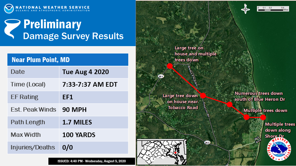
...EF-1 TORNADO CONFIRMED AT PLUM POINT IN CALVERT COUNTY MARYLAND...
Location... in Calvert Co MD
Date...Tue Aug 4 2020
Estimated Time...7:33 AM EDT to 7:37 AM EDT
Maximum EF-Scale Rating...EF-1
Estimated Maximum Wind Speed...90 mph
Maximum Path Width...100 yards
Path Length...1.7 miles
Beginning Lat/Lon...38.615/-76.512
Ending Lat/Lon...38.627/-76.542
* Fatalities...0
* Injuries...0
...Summary...
Staff from NOAAs National Weather Service Baltimore/Washington DC
Weather Forecast Office in Sterling, VA, performed a survey of storm
damage that occurred the morning of August 4, 2020, in Calvert County,
Maryland. At 7:33 AM EDT, an EF-1 tornado came onshore at Plum
Point near Beach Drive approximately 5 miles east of Huntingtown,
MD. The tornado moved west along Shore Drive, uprooting numerous
trees and snapping and twisting others. A large tree halfway
along Shore Drive fell on a house, causing structural damage. The
tornado proceeded to move to the end of Shore Drive and shifted
southwest along Ridge Road causing trees to snap about 20 feet up
and fall in multiple directions. Some trees that were snapped were
a foot and a half in diameter.
The tornado then moved across Plum Point Creek and the grassy wetlands
toward Tobacco Road. A swath of trees had their tops broken off east of
Tobacco Road and fell mainly in a south to west direction.
The tornado then proceeded up Tobacco Road near Tobacco Lane, and
moved northward towards Breezy Point Road. Peak winds in the tornado
were estimated to have reached 90 mph here. Over 30 trees were
uprooted, and some were broken in half. A house had a tree fall on
it along the Tobacco Road area, and windows were blown in on another
house. Tobacco Road had over 10 trees fall westward over the road
along with multiple power poles. A 75 to 100 yard path of tree
damage was observed east of Tobacco Road with trees falling in
multiple directions. The area of Tobacco Road from Pinewood Terrace
to Tobacco Lane became impassable due to the tree and power line
damage, and the Breezy Point area became cut off from the main road.
The tornado moved west after passing Breezy Point Road and caused
numerous trees to fall along Route 261/Bayside Road near Bristol
Drive. A large tree near the intersection of Route 261 and Bristol
Drive fell on a house. The tree damage path was observed up to
50 to 75 feet down the north end of Bristol Drive. The tornado
weakened after passing the intersection of Bristol Drive and Route
261 and ended at 7:37 AM EDT.
The National Weather Service would like to thank Calvert County's
Department of Public Safety and Office of Emergency Management for
assisting with our damage survey.
EF Scale: The Enhanced Fujita Scale classifies tornadoes into the
following categories:
EF0.........65 to 85 mph
EF1.........86 to 110 mph
EF2.........111 to 135 mph
EF3.........136 to 165 mph
EF4.........166 to 200 mph
EF5.........>200 mph
* The information in this statement is preliminary and subject to
change pending final review of the event and publication in NWS
Storm Data.
--------------------------------------------------------------------------------------------------------------------
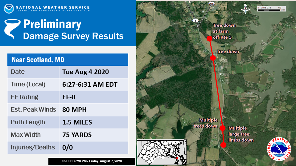
...EF-0 TORNADO CONFIRMED NEAR SCOTLAND IN ST. MARYS COUNTY
MARYLAND...
Location...Scotland in St. Marys Co MD
Date...Tue Aug 4 2020
Estimated Time...6:27 AM EDT to 6:31 AM EDT
Maximum EF-Scale Rating...EF-0
Estimated Maximum Wind Speed...80 mph
Maximum Path Width...75 yards
Path Length...1.5 miles
Beginning Lat/Lon...38.093/-76.365
Ending Lat/Lon...38.114/-76.369
* Fatalities...0
* Injuries...0
...Summary...
Staff from NOAAs National Weather Service Baltimore/Washington DC
Weather Forecast Office in Sterling, VA, performed a survey of storm
damage that occurred the morning of August 4, 2020, in St. Marys County,
Maryland.
At 6:27 AM EDT, a tornado rated EF-0 caused damage near Scotland, MD.
The survey found tree damage along a portion of Point Lookout
Road between St. Gabriels Manor Way and Fresh Pond Neck Road.
First evidence of tornado touchdown was near the intersection of
St. Gabriels Manor Way and Route 5/Point Lookout Rd where numerous
tree limbs were down.
As the tornado moved north-northwest, numerous trees were snapped
or downed all along the 12800 block of Point Lookout Rd. An
entire row of cedar trees was pushed over behind one residence. A
resident who was home when the tornado passed over stated they
heard a violent roaring sound, the house visibly shook, and then
it was over in a matter of seconds. A row of trees behind the
residence was uprooted during this time.
The tornado lifted shortly before crossing Fresh Pond Neck Road at
Point Lookout Rd and then touched down further north near the
intersection of Curleys Rd and Point Lookout Rd knocking down a
tree on Curleys Rd. The tornado finally knocked down a tree on a
farm just northeast of the aforementioned intersection before
lifting at 6:31 AM EDT.
EF Scale: The Enhanced Fujita Scale classifies tornadoes into the
following categories:
EF0.........65 to 85 mph
EF1.........86 to 110 mph
EF2.........111 to 135 mph
EF3.........136 to 165 mph
EF4.........166 to 200 mph
EF5.........>200 mph
* The information in this statement is preliminary and subject to
change pending final review of the event and publication in NWS
Storm Data.
--------------------------------------------------------------------------------------------------------------------
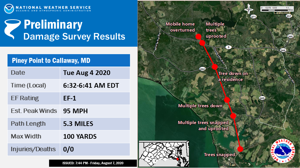
...EF-1 TORNADO CONFIRMED FROM PINEY POINT TO CALLAWAY IN ST. MARYS
COUNTY MARYLAND...
Location...Piney Point to Callaway in St. Marys Co MD
Date...Tue Aug 4 2020
Estimated Time...6:32 AM EDT to 6:41 AM EDT
Maximum EF-Scale Rating...EF-1
Estimated Maximum Wind Speed...95 mph
Maximum Path Width...100 yards
Path Length...5.3 miles
Beginning Lat/Lon...38.174/-76.528
Ending Lat/Lon...38.245/-76.562
* Fatalities...0
* Injuries...0
...Summary...
Staff from NOAAs National Weather Service Baltimore/Washington
DC Weather Forecast Office in Sterling, VA, performed a survey of
storm damage that occurred the morning of August 4, 2020, in St.
Marys County, Maryland.
At 6:32 AM EDT, a tornado rated EF-1 formed soon after the storm
moved northwest of Piney Point, MD. Consistent tree damage began
along Piney Point Road between Tall Timbers and Valley Lee. An
aerial survey was conducted, and a path of snapped and uprooted
trees about 75 to 100 yards wide was noted extending to the
northwest through the woods and fields of rural St. Marys
County. Some roads having multiple trees downed along this path
included Blake Creek Road, Richey Road, and Medleys Neck Road.
Homes were damaged by falling trees, including one along Medleys
Neck Road near the intersection with Scarlet Tanager Way.
The tornado crossed Route 5/Point Lookout Road near the
intersection with Lightfoot Way. Here there was also significant
tree damage. Large trees were uprooted damaging a shed and a home.
A mobile home/camper was blown over on its side. The tornado then
dissipated at 6:41 AM EDT.
Peak winds during the track of the tornado were estimated at 95
mph, mainly based on the number of snapped and uprooted trees
within the track.
The National Weather Service would like to thank St. Marys
County Dept. of Emergency Services and Emergency Management
Division, the Maryland Emergency Management Agency, and Maryland
State Police for their invaluable assistance with this survey.
EF Scale: The Enhanced Fujita Scale classifies tornadoes into the
following categories:
EF0.........65 to 85 mph
EF1.........86 to 110 mph
EF2.........111 to 135 mph
EF3.........136 to 165 mph
EF4.........166 to 200 mph
EF5.........>200 mph
* The information in this statement is preliminary and subject to
change pending final review of the event and publication in NWS
Storm Data.
--------------------------------------------------------------------------------------------------------------------


 Coastal Flood
 FAQ
FAQ