
A significant heat wave continues for the Rockies, Northern Plains, and Great Lakes into the Mid-Atlantic, peaking in intensity through midweek and lingering across parts of the Northern Plains and Midwest until this weekend. Excessive rainfall my bring life-threatening and locally catastrophic flash and urban flooding across portions of southwestern Texas through early Friday. Read More >
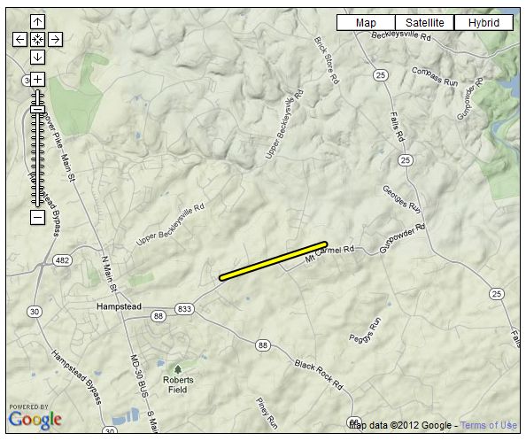
...EF-0 TORNADO CONFIRMED NEAR HAMPSTEAD MARYLAND...

LOCATION...WESTERN BALTIMORE COUNTY...2 MILES EAST OF HAMPSTEAD
DATE...APRIL 28 2011
ESTIMATED TIME...8:09 AM TO 8:11 AM EDT
MAXIMUM EF-SCALE RATING...EF-0
MAXIMUM WIND SPEED...65 MPH
MAXIMUM PATH WIDTH...50 YARDS
LENGTH...1.1 MILES
BEGINNING LAT/LON...39.609N / 76.830W
ENDING LAT/LON...39.614N / 76.810W
* FATALITIES...NONE
* INJURIES...NONE

* THE INFORMATION IN THIS STATEMENT IS PRELIMINARY AND SUBJECT TO
CHANGE PENDING FINAL REVIEW OF THE EVENT/S/ AND PUBLICATION IN NWS
STORM DATA.

...SUMMARY...

A GROUND SURVEY CONDUCTED BY THE NATIONAL WEATHER SERVICE...TOGETHER
WITH RADAR AND EYEWITNESS REPORTS DETERMINED THAT AN EF-0 TORNADO
TRACKED FROM NEAR THE CARROLL COUNTY LINE IN BALTIMORE COUNTY ALONG
MT CARMEL ROAD FOR 1.1 MILES. THE TORNADO SNAPPED AND UPROOTED
SEVERAL TREES AND DOWNED LARGE BRANCHES. THE STORM TRACKED ACROSS
MARSHALL MILL ROAD.


 Coastal Flood
 FAQ
FAQ