
A significant heat wave is underway for the Intermountain West, Northern Plains, and Upper Great Lakes, peaking in intensity through midweek and lingering across parts of the Northern Plains and Midwest until this weekend. In southwest Texas, excessive rainfall may bring a risk for potentially life-threatening flash and arroyo flooding through Thursday. Read More >
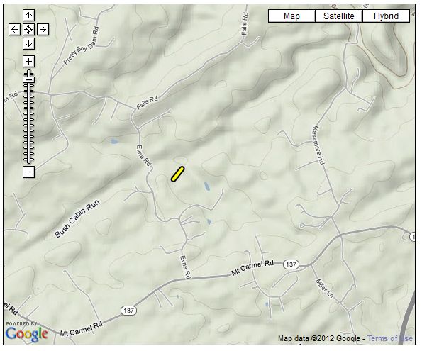
...EF-0 TORNADO CONFIRMED NEAR HEREFORD MARYLAND...

LOCATION...NORTHERN BALTIMORE COUNTY...2 MILES WEST-NW OF HEREFORD
DATE...APRIL 28 2011
ESTIMATED TIME...9:54 AM TO 9:54 AM EDT
MAXIMUM EF-SCALE RATING...EF-0
MAXIMUM WIND SPEED...70 MPH
MAXIMUM PATH WIDTH...75 YARDS
LENGTH...0.1 MILES
BEGINNING LAT/LON...39.598N / 76.705W
ENDING LAT/LON...39.599N / 76.704W
* FATALITIES...NONE
* INJURIES...NONE

* THE INFORMATION IN THIS STATEMENT IS PRELIMINARY AND SUBJECT TO
CHANGE PENDING FINAL REVIEW OF THE EVENT/S/ AND PUBLICATION IN NWS
STORM DATA.

...SUMMARY...

BASED UPON RESULTS FROM AN AERIAL SURVEY CONDUCTED BY BALTIMORE
COUNTY...THE NATIONAL WEATHER SERVICE HAS DETERMINED AN EF-0
TORNADO TOUCHED DOWN BRIEFLY JUST NORTH OF EVNA ROAD IN A HEAVILY
WOODED AREA. DAMAGE WAS LIMITED TO TREES...NO STRUCTURES WERE
IMPACTED. THE TORNADO SNAPPED AND UPROOTED ABOUT TWO DOZEN TREES
AND DOWNED LARGE BRANCHES. THE TORNADO DAMAGE HAS BEEN RATED EF-0
WITH MAX WINDS OF 75 MPH...PATH WIDTH OF 75 YARDS AND WAS ON THE
GROUND FOR NO MORE THAN ONE MINUTE.


 Coastal Flood
 FAQ
FAQ