
Hurricane Isaias has made landfall near Destin, Florida and will continue to move inland overnight. Hurricane conditions are expected through early Saturday within the Hurricane Warning area. A life-threatening storm surge is expected from Dauphin Island, Alabama to Suwannee, Florida where a Storm Surge Warning remains in effect. Heavy rainfall to spread inland into the Southeast on Saturday. Read More >
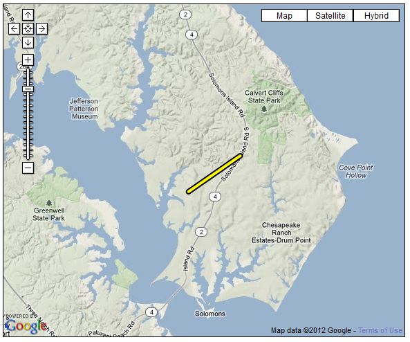
...EF-0 TORNADO CONFIRMED IN LUSBY MD...

LOCATION...LUSBY IN CALVERT COUNTY MD
DATE...APRIL 28 2011
ESTIMATED TIME...11:41 AM TO 11:43 PM EDT
MAXIMUM EF-SCALE RATING...EF-0
MAXIMUM WIND SPEED...70 MPH
MAXIMUM PATH WIDTH...50 YARDS
LENGTH...1.8 MILES
BEGINNING LAT/LON...38.366N / 76.465W
ENDING LAT/LON...38.380N / 76.439W
* FATALITIES...NONE
* INJURIES...NONE

* THE INFORMATION IN THIS STATEMENT IS PRELIMINARY AND SUBJECT TO
CHANGE PENDING FINAL REVIEW OF THE EVENT/S/ AND PUBLICATION IN NWS
STORM DATA.

...SUMMARY...

A GROUND SURVEY CONDUCTED BY THE NATIONAL WEATHER SERVICE...TOGETHER
WITH RADAR AND EYEWITNESS REPORTS DETERMINED THAT AN EF-0 TORNADO
TRACKED BRIEFLY FROM NEAR THE INTERSECTION OF HILLTOP ROAD AND
COSTER ROAD TO THE INTERSECTION OF SOLOMONS ISLAND ROAD AND
SWEETWATER ROAD. SIX INSTANCES OF DAMAGE WERE NOTED ALONG THE
PATH...INCLUDING APPROXIMATELY A DOZEN TREES THAT WERE UPROOTED...
ALONG WITH LARGE BRANCHES DOWNED.



 Radar
Radar Current Weather
 Rivers & Lakes
 Satellite
 Forecast Maps
 Hour by Hour Forecast
 Tropical Weather
 Graphical Hazards
 Marine Forecasts
 Forecaster's Discussion
 Text Bulletins
 Fire Weather
 Weather Hazard Briefing
 Climate Plots
 Coastal Flood
 Skywarn
 Submit Storm Report
 FAQ
FAQ Follow us on X
 Follow us on Facebook
 Follow us on YouTube
 LWX RSS Feed