
Dangerous heat will expand from the Gulf Coast into the Southern Plains and Desert Southwest through week's end. Additional extreme heat impacting the Pacific Northwest will shift to the northern Plains by the weekend. Tropical Storm Bertha is expected to continue to impact portions of the northern Gulf Coast from the western Florida Panhandle to southeastern Louisiana through tonight. Read More >
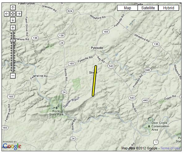
...EF-0 TORNADO CONFIRMED NEAR STREET MARYLAND...

LOCATION...NORTH CENTRAL HARFORD COUNTY NEAR STREET MARYLAND
DATE...JUNE 12 2011
ESTIMATED TIME...4:07 PM TO 4:10 PM EDT
MAXIMUM EF-SCALE RATING...EF-0
MAXIMUM WIND SPEED...70 MPH
MAXIMUM PATH WIDTH...75 YARDS
LENGTH...1.7 MILES
BEGINNING LAT/LON...39.674N / 76.375W
ENDING LAT/LON...39.649N / 76.378W
* FATALITIES...NONE
* INJURIES...NONE

* THE INFORMATION IN THIS STATEMENT IS PRELIMINARY AND SUBJECT TO
CHANGE PENDING FINAL REVIEW OF THE EVENT/S/ AND PUBLICATION IN NWS
STORM DATA.

...SUMMARY...

A GROUND SURVEY CONDUCTED BY THE NATIONAL WEATHER SERVICE DETERMINED
AN EF-0 TORNADO WITH MAXIMUM WINDS ESTIMATED AT 70 MPH PRODUCED
TREE DAMAGE ALONG A 1.7 MILE LONG PATH. INITIAL DAMAGE OCCURRED
JUST NORTH OF STREET ALONG STREET ROAD...AND CONTINUED SOUTH
PRODUCING SCATTERED TREE DAMAGE ALONG MILLERS ROAD. TREES WERE
UPROOTED AND SNAPPED IN SPOTS ALONG THE PATH. NO DAMAGE TO ANY
STRUCTURES WAS OBSERVED.

THE TORNADO LIFTED SHORTLY AFTER CROSSING MILLERS ROAD JUST EAST
OF GRIER NURSERY ROAD AND WAS ESTIMATED TO HAVE LASTED FOR ABOUT
THREE MINUTES.


 Coastal Flood
 FAQ
FAQ