
Scattered thunderstorms with severe gusts, hail and a tornado risk are possible near a cold front from the Ohio Valley to the Mid-Atlantic tonight. Tropical Storm Bertha is expected to bring tropical storm conditions to portions of the Gulf Coast from the panhandle of Florida into Louisiana through Wednesday. Read More >
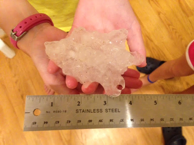
VERY LARGE HAIL OCCURRED FROM A SUPERCELL THUNDERSTORM IN THE LATE
AFTERNOON OF TUESDAY...JUNE 23 2015 IN CENTRAL BALTIMORE COUNTY.

AROUND 545 PM...A HAILSTONE WAS FOUND IN THE FRONT YARD OF A
RESIDENCE 2 MILES NORTH-NORTHEAST OF TIMONIUM MARYLAND THAT MEASURED
4.0 INCHES IN DIAMETER...GRAPEFRUIT SIZE. THIS IS ONLY THE 4TH CASE
OF HAIL MEASURING 4 OR MORE INCHES IN MARYLAND FROM RECORDS DATING
BACK TO 1950.

THE LARGEST HAIL ON RECORD IN MARYLAND SINCE 1950 IS 4.5 INCHES...
SOFTBALL SIZE. HAIL THIS SIZE HAS BEEN RECORDED TWICE...ONCE ON
APRIL 28 2002 IN CHARLES COUNTY ASSOCIATED WITH THE SUPERCELL THAT
PRODUCED THE LA PLATA EF4 TORNADO. THE OTHER 4.5 INCH HAILSTONE FELL
ON JUNE 18 1970 IN THE PHOENIX-JACKSONVILLE-COCKEYSVILLE AREA OF
BALTIMORE COUNTY.

THE OTHER KNOWN 4.0 INCH DIAMETER HAIL REPORT IN MARYLAND WAS ON
JULY 31 1999 IN NORTHERN BALTIMORE COUNTY NEAR HEREFORD.


 Coastal Flood
 FAQ
FAQ