National Weather Service United States Department of Commerce
Click a location below for detailed forecast.

Last Map Update: Mon, Jun 23, 2025 at 11:44:18 pm CDT

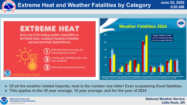
Heat illness and heat-related deaths occur more often NOT within a heatwave or period of extreme heat. Often times, transitioning from slightly cooler weather to much warmer weather can lead to heat- related illness or death because the change of much warmer weather is often overlooked by keeping the same routine. Unfortunately, this can lead to heat safety being overlooked.
Dangerous heat index values will persist through this week with values between 105 and 109 degrees within the Heat Advisory. Hot and humid conditions will require those outdoor whether working or recreating to practice heat safety. An isolated shower or thunderstorm is possible each afternoon with any shower or thunderstorm that does form dissipating just after sunset.
Low temperatures tonight are expected to fall into the 70s. Upper 70s in some locations which will not provide good relief from the daytime heat.
Hot and humid conditions are expected this upcoming work week into the weekend. Most locations around the state will see temperatures climb well into the 90s with heat index values approaching or exceeding 105 in places. Here are some heat related safety tips for those working or recreating outdoors. Remember, heat is the number one weather related killer! So don't let heat related illnesses sneak up on you!
The long term forecast favors a hot and humid pattern to persist across the forecast area into at least next week, as upper level high pressure settles over the region.

 
Hourly Weather Roundup ( )
Location Sky/Weather Temp Dewpt RH Wind Baro Remarks
Fayetteville
N/A
N/A
N/A
N/A
N/A
N/A
N/A
Harrison
N/A
N/A
N/A
N/A
N/A
N/A
N/A
Mountain Home
N/A
N/A
N/A
N/A
N/A
N/A
N/A
Jonesboro
N/A
N/A
N/A
N/A
N/A
N/A
N/A
Fort Smith
N/A
N/A
N/A
N/A
N/A
N/A
N/A
Russellville
N/A
N/A
N/A
N/A
N/A
N/A
N/A
Mount Ida
N/A
N/A
N/A
N/A
N/A
N/A
N/A
Hot Springs
N/A
N/A
N/A
N/A
N/A
N/A
N/A
Little Rock
N/A
N/A
N/A
N/A
N/A
N/A
N/A
North Little Rock
N/A
N/A
N/A
N/A
N/A
N/A
N/A
West Memphis
N/A
N/A
N/A
N/A
N/A
N/A
N/A
Texarkana
N/A
N/A
N/A
N/A
N/A
N/A
N/A
El Dorado
N/A
N/A
N/A
N/A
N/A
N/A
N/A
Pine Bluff
N/A
N/A
N/A
N/A
N/A
N/A
N/A
Monticello
N/A
N/A
N/A
N/A
N/A
N/A
N/A
Note: "N/A" or "MISG" will be displayed if values are not available. In the LOCATION column, click on links for a list of recent observations at sites of interest. In the WIND column, VRB is "variable" and G is "gust". Wind speeds are in MPH. In the BARO (pressure) column, values are in inches. In the REMARKS column, HX is "heat index", WCI is "wind chill index", and VSB is "visibility" (if shown).
 
 
Point Forecasts
Cities in Arkansas Coordinates (make sure "Lon" is negative)
Lat:   Lon:
 
Local Hazards
Local Hazards
Decision Support
Decision Support
Submit Storm Report
Submit Storm Report
Local Forecast Page
Local Forecast Page
Radar Links
Radar Links
Local Climate Page
Local Climate Page
Local Observations Page
Local Satellite Page
Local Drought Page
Local Drought Page
Local Hydrology Page
Local Fire Page
Local Fire Page
Text Product Viewer
Text Product Viewer