National Weather Service United States Department of Commerce
Click a location below for detailed forecast.

Last Map Update: Thu, Apr 2, 2026 at 8:50:17 am CDT

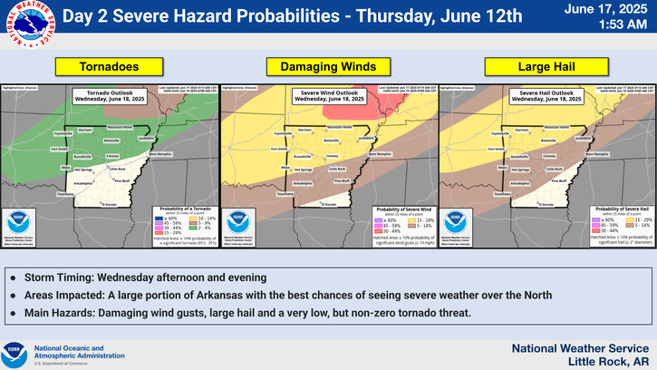
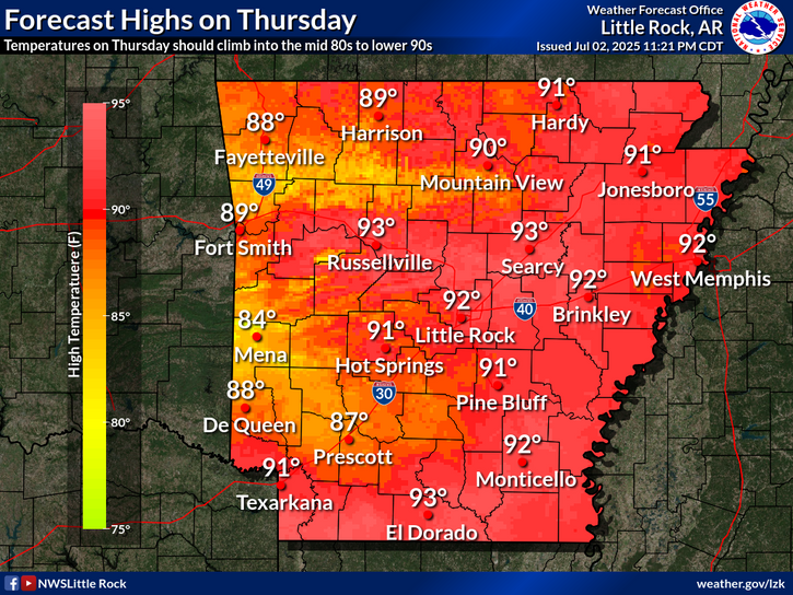
A limited severe weather potential will exist across far north-central Arkansas and far northeastern Arkansas. A severe hail risk coupled with the possibility of a tornado or two will exist if instability manages to support severe thunderstorm development into part of northern Arkansas. Confidence remains low overall for the instability, but the situation will need to be monitored as a small window on Thursday PM will exist.
Thursday afternoon high temperatures will top out in the upper 70s to mid 80s across the state.
Non-thunderstorm winds will be gusty Thursday throughout the day. -Widespread 35mph gust north of I-40 expected. -Better chance for gusts ≥40mph along the I-57 corridor and higher elevations in NW Arkansas
Rainfall chances will be on the increase with Friday and Saturday looking to be the wettest days. Much of the state has a decent chance of seeing rain in excess of 1.5 inches.
Drought conditions remain over Arkansas at this time with a lot of rain needed over the next 30 days to break said drought. This map shows how much rain is needed over the next month or so to end the drought.
Fire danger remains high across all of Arkansas as our drought continues. Numerous counties are now under burn bans with all outdoor burning prohibited.

 
Hourly Weather Roundup ( )
Location Sky/Weather Temp Dewpt RH Wind Baro Remarks
Fayetteville
N/A
N/A
N/A
N/A
N/A
N/A
N/A
Harrison
N/A
N/A
N/A
N/A
N/A
N/A
N/A
Mountain Home
N/A
N/A
N/A
N/A
N/A
N/A
N/A
Jonesboro
N/A
N/A
N/A
N/A
N/A
N/A
N/A
Fort Smith
N/A
N/A
N/A
N/A
N/A
N/A
N/A
Russellville
N/A
N/A
N/A
N/A
N/A
N/A
N/A
Mount Ida
N/A
N/A
N/A
N/A
N/A
N/A
N/A
Hot Springs
N/A
N/A
N/A
N/A
N/A
N/A
N/A
Little Rock
N/A
N/A
N/A
N/A
N/A
N/A
N/A
North Little Rock
N/A
N/A
N/A
N/A
N/A
N/A
N/A
West Memphis
N/A
N/A
N/A
N/A
N/A
N/A
N/A
Texarkana
N/A
N/A
N/A
N/A
N/A
N/A
N/A
El Dorado
N/A
N/A
N/A
N/A
N/A
N/A
N/A
Pine Bluff
N/A
N/A
N/A
N/A
N/A
N/A
N/A
Monticello
N/A
N/A
N/A
N/A
N/A
N/A
N/A
Note: "N/A" or "MISG" will be displayed if values are not available. In the LOCATION column, click on links for a list of recent observations at sites of interest. In the WIND column, VRB is "variable" and G is "gust". Wind speeds are in MPH. In the BARO (pressure) column, values are in inches. In the REMARKS column, HX is "heat index", WCI is "wind chill index", and VSB is "visibility" (if shown).
 
 
Point Forecasts
Cities in Arkansas Coordinates (make sure "Lon" is negative)
Lat:   Lon:
 
Local Hazards
Local Hazards
Decision Support
Decision Support
Submit Storm Report
Submit Storm Report
Local Forecast Page
Local Forecast Page
Radar Links
Radar Links
Local Climate Page
Local Climate Page
Local Observations Page
Local Satellite Page
Local Drought Page
Local Drought Page
Local Hydrology Page
Local Fire Page
Local Fire Page
Text Product Viewer
Text Product Viewer