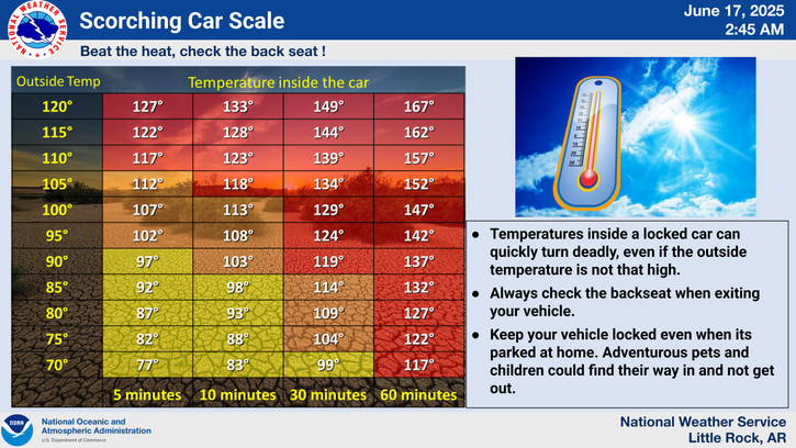
National Weather Service United States Department of Commerce
Click a location below for detailed forecast.

Last Map Update: Sat, May 24, 2025 at 11:20:19 pm CDT

Here is a local radar view.
A Flood Watch remains in effect for the northern half of the state through Monday Evening. Portions of northwest to north and east Arkansas have received between 3 to 5 inches of rain as of Saturday afternoon. Additional rainfall between 2 to 4 inches and up to 4 to 6 inches through Monday evening in some locations will quickly yield a flash flooding threat.
Additional significant rainfall is still expected over much of the state through Tuesday night. Several areas have seen significant rainfall of 2 to 5 inches already, resulting in a higher vulnerability to flash flooding with additional rain.
Here is a look at 24 hour estimated rainfall as of 12 PM CDT on Saturday. Portions of north and northeast Arkansas have seen significant rainfall up to now (3 to 5 inches or more), with much of the state seeing 1 to 3 inches of rain so far. Unfortunately, more rainfall is still expected.
Your low temperature forecast for Sunday Morning.
Your high temperature forecast for Sunday.

 
Hourly Weather Roundup ( )
Location Sky/Weather Temp Dewpt RH Wind Baro Remarks
Fayetteville
N/A
N/A
N/A
N/A
N/A
N/A
N/A
Harrison
N/A
N/A
N/A
N/A
N/A
N/A
N/A
Mountain Home
N/A
N/A
N/A
N/A
N/A
N/A
N/A
Jonesboro
N/A
N/A
N/A
N/A
N/A
N/A
N/A
Fort Smith
N/A
N/A
N/A
N/A
N/A
N/A
N/A
Russellville
N/A
N/A
N/A
N/A
N/A
N/A
N/A
Mount Ida
N/A
N/A
N/A
N/A
N/A
N/A
N/A
Hot Springs
N/A
N/A
N/A
N/A
N/A
N/A
N/A
Little Rock
N/A
N/A
N/A
N/A
N/A
N/A
N/A
North Little Rock
N/A
N/A
N/A
N/A
N/A
N/A
N/A
West Memphis
N/A
N/A
N/A
N/A
N/A
N/A
N/A
Texarkana
N/A
N/A
N/A
N/A
N/A
N/A
N/A
El Dorado
N/A
N/A
N/A
N/A
N/A
N/A
N/A
Pine Bluff
N/A
N/A
N/A
N/A
N/A
N/A
N/A
Monticello
N/A
N/A
N/A
N/A
N/A
N/A
N/A
Note: "N/A" or "MISG" will be displayed if values are not available. In the LOCATION column, click on links for a list of recent observations at sites of interest. In the WIND column, VRB is "variable" and G is "gust". Wind speeds are in MPH. In the BARO (pressure) column, values are in inches. In the REMARKS column, HX is "heat index", WCI is "wind chill index", and VSB is "visibility" (if shown).
 
 
Point Forecasts
Cities in Arkansas Coordinates (make sure "Lon" is negative)
Lat:   Lon:
 
Local Hazards
Local Hazards
Decision Support
Decision Support
Submit Storm Report
Submit Storm Report
Local Forecast Page
Local Forecast Page
Radar Links
Radar Links
Local Climate Page
Local Climate Page
Local Observations Page
Local Satellite Page
Local Drought Page
Local Drought Page
Local Hydrology Page
Local Fire Page
Local Fire Page
Text Product Viewer
Text Product Viewer