National Weather Service United States Department of Commerce
Click a location below for detailed forecast.

Last Map Update: Fri, May 2, 2025 at 11:42:22 pm CDT

Here is a local radar view.
The severe weather threat will move south and southeast this this evening and overnight. Damaging winds will be the primary threat with the strongest of thunderstorms. Locally heavy rainfall may also be seen.
Lows tonight should range from the mid 40s to around 60 degrees
High temperatures on Saturday should climb into the mid 60s to mid 70s.
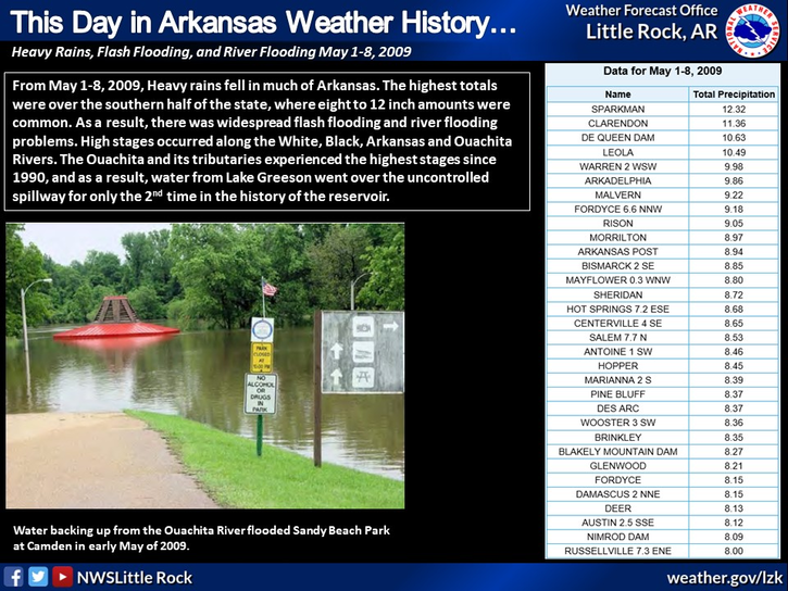
On this day in weather history, a multi day day rain event was starting to unfold which resulted in widespread flooding. The highest amounts occurred over the southern half of the state where well over a foot of rain fell. High stages were common on many of our rivers.

 
Hourly Weather Roundup ( )
Location Sky/Weather Temp Dewpt RH Wind Baro Remarks
Fayetteville
N/A
N/A
N/A
N/A
N/A
N/A
N/A
Harrison
N/A
N/A
N/A
N/A
N/A
N/A
N/A
Mountain Home
N/A
N/A
N/A
N/A
N/A
N/A
N/A
Jonesboro
N/A
N/A
N/A
N/A
N/A
N/A
N/A
Fort Smith
N/A
N/A
N/A
N/A
N/A
N/A
N/A
Russellville
N/A
N/A
N/A
N/A
N/A
N/A
N/A
Mount Ida
N/A
N/A
N/A
N/A
N/A
N/A
N/A
Hot Springs
N/A
N/A
N/A
N/A
N/A
N/A
N/A
Little Rock
N/A
N/A
N/A
N/A
N/A
N/A
N/A
North Little Rock
N/A
N/A
N/A
N/A
N/A
N/A
N/A
West Memphis
N/A
N/A
N/A
N/A
N/A
N/A
N/A
Texarkana
N/A
N/A
N/A
N/A
N/A
N/A
N/A
El Dorado
N/A
N/A
N/A
N/A
N/A
N/A
N/A
Pine Bluff
N/A
N/A
N/A
N/A
N/A
N/A
N/A
Monticello
N/A
N/A
N/A
N/A
N/A
N/A
N/A
Note: "N/A" or "MISG" will be displayed if values are not available. In the LOCATION column, click on links for a list of recent observations at sites of interest. In the WIND column, VRB is "variable" and G is "gust". Wind speeds are in MPH. In the BARO (pressure) column, values are in inches. In the REMARKS column, HX is "heat index", WCI is "wind chill index", and VSB is "visibility" (if shown).
 
 
Point Forecasts
Cities in Arkansas Coordinates (make sure "Lon" is negative)
Lat:   Lon:
 
Local Hazards
Local Hazards
Decision Support
Decision Support
Submit Storm Report
Submit Storm Report
Local Forecast Page
Local Forecast Page
Radar Links
Radar Links
Local Climate Page
Local Climate Page
Local Observations Page
Local Satellite Page
Local Drought Page
Local Drought Page
Local Hydrology Page
Local Fire Page
Local Fire Page
Text Product Viewer
Text Product Viewer