National Weather Service United States Department of Commerce
Click a location below for detailed forecast.

Last Map Update: Sun, May 17, 2026 at 3:10:31 pm CDT

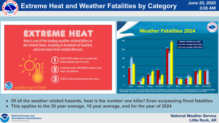
There is a marginal risk for an isolated strong to severe thunderstorms across the western , northern, south & southwest, a Arkansas this afternoon and evening. The primary hazards will be damaging winds and large hail.
Damaging wind gusts are the primary severe weather hazard. Isolated large hail cannot be ruled out but expected to remain below severe criteria.
Sunday high temperatures will range from the mid 80s to the lower 90s across the state. The highest temperatures will be in Eastern Arkansas.
The upcoming week will allow for numerous chances for rain and storms to impact the state. Total rainfall will likely exceed 1 inch across most of the state and a few location may near or exceed 2 inches of total rainfall.
Temperatures Monday morning will feel rather sticky with high humidity to start the day and will range in the lower to mid 70s across the state.
Showers and thunderstorms are expected to develop along and ahead of an advancing cold front Tuesday afternoon and evening. Damaging winds are expected to be the main threat.
Mainly wind gusts < 75 mph and mostly hail sizes ≤ 2” are reasonable max threats with this round of thunderstorms. Greatest likelihood of severe storms would be Tuesday morning and afternoon.
Scattered to isolated severe storms are possible Monday evening into Tuesday. Damaging wind gusts are the primary severe weather hazard. Isolated large hail cannot be ruled out but expected to remain below severe criteria.

 
Hourly Weather Roundup ( )
Location Sky/Weather Temp Dewpt RH Wind Baro Remarks
Fayetteville
N/A
N/A
N/A
N/A
N/A
N/A
N/A
Harrison
N/A
N/A
N/A
N/A
N/A
N/A
N/A
Mountain Home
N/A
N/A
N/A
N/A
N/A
N/A
N/A
Jonesboro
N/A
N/A
N/A
N/A
N/A
N/A
N/A
Fort Smith
N/A
N/A
N/A
N/A
N/A
N/A
N/A
Russellville
N/A
N/A
N/A
N/A
N/A
N/A
N/A
Mount Ida
N/A
N/A
N/A
N/A
N/A
N/A
N/A
Hot Springs
N/A
N/A
N/A
N/A
N/A
N/A
N/A
Little Rock
N/A
N/A
N/A
N/A
N/A
N/A
N/A
North Little Rock
N/A
N/A
N/A
N/A
N/A
N/A
N/A
West Memphis
N/A
N/A
N/A
N/A
N/A
N/A
N/A
Texarkana
N/A
N/A
N/A
N/A
N/A
N/A
N/A
El Dorado
N/A
N/A
N/A
N/A
N/A
N/A
N/A
Pine Bluff
N/A
N/A
N/A
N/A
N/A
N/A
N/A
Monticello
N/A
N/A
N/A
N/A
N/A
N/A
N/A
Note: "N/A" or "MISG" will be displayed if values are not available. In the LOCATION column, click on links for a list of recent observations at sites of interest. In the WIND column, VRB is "variable" and G is "gust". Wind speeds are in MPH. In the BARO (pressure) column, values are in inches. In the REMARKS column, HX is "heat index", WCI is "wind chill index", and VSB is "visibility" (if shown).
 
 
Point Forecasts
Cities in Arkansas Coordinates (make sure "Lon" is negative)
Lat:   Lon:
 
Local Hazards
Local Hazards
Decision Support
Decision Support
Submit Storm Report
Submit Storm Report
Local Forecast Page
Local Forecast Page
Radar Links
Radar Links
Local Climate Page
Local Climate Page
Local Observations Page
Local Satellite Page
Local Drought Page
Local Drought Page
Local Hydrology Page
Local Fire Page
Local Fire Page
Text Product Viewer
Text Product Viewer