National Weather Service United States Department of Commerce
Click a location below for detailed forecast.

Last Map Update: Mon, Sep 29, 2025 at 4:20:42 pm CDT

Dry weather pattern will persist across much of the central United States as an expansive area of ridging remains situated across the Mid Mississippi and Ohio Valley regions. Morning temperatures will feel pleasant over the next several days with afternoon highs topping out in the 80s across the Natural State. Looking towards the tropics, Hurricane Humberto will get caught up in strong westerlies which will steer the system away from the east coast.
Calm and dry conditions are expected over at least the next 5 days as high pressure takes control of the weather pattern. Temperatures are expected to be slight above average with highs in the upper 70s to mid 80s across the state.
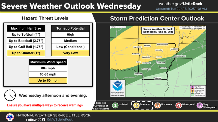
In a nutshell, it is going to be dry through Saturday at least. Even with the very heavy rainfall parts of the state saw last week, only western Arkansas has a soil moisture surplus at this time. With the current forecast, all of the state will continue to dry out.
Low temperatures Monday morning will range from the upper 50s to lower 60s across the state. It seems like an open the windows kind of night.
Under mostly sunny skies, high temperatures on Monday will top out in the 80s across Arkansas.

 
Hourly Weather Roundup ( )
Location Sky/Weather Temp Dewpt RH Wind Baro Remarks
Fayetteville
N/A
N/A
N/A
N/A
N/A
N/A
N/A
Harrison
N/A
N/A
N/A
N/A
N/A
N/A
N/A
Mountain Home
N/A
N/A
N/A
N/A
N/A
N/A
N/A
Jonesboro
N/A
N/A
N/A
N/A
N/A
N/A
N/A
Fort Smith
N/A
N/A
N/A
N/A
N/A
N/A
N/A
Russellville
N/A
N/A
N/A
N/A
N/A
N/A
N/A
Mount Ida
N/A
N/A
N/A
N/A
N/A
N/A
N/A
Hot Springs
N/A
N/A
N/A
N/A
N/A
N/A
N/A
Little Rock
N/A
N/A
N/A
N/A
N/A
N/A
N/A
North Little Rock
N/A
N/A
N/A
N/A
N/A
N/A
N/A
West Memphis
N/A
N/A
N/A
N/A
N/A
N/A
N/A
Texarkana
N/A
N/A
N/A
N/A
N/A
N/A
N/A
El Dorado
N/A
N/A
N/A
N/A
N/A
N/A
N/A
Pine Bluff
N/A
N/A
N/A
N/A
N/A
N/A
N/A
Monticello
N/A
N/A
N/A
N/A
N/A
N/A
N/A
Note: "N/A" or "MISG" will be displayed if values are not available. In the LOCATION column, click on links for a list of recent observations at sites of interest. In the WIND column, VRB is "variable" and G is "gust". Wind speeds are in MPH. In the BARO (pressure) column, values are in inches. In the REMARKS column, HX is "heat index", WCI is "wind chill index", and VSB is "visibility" (if shown).
 
 
Point Forecasts
Cities in Arkansas Coordinates (make sure "Lon" is negative)
Lat:   Lon:
 
Local Hazards
Local Hazards
Decision Support
Decision Support
Submit Storm Report
Submit Storm Report
Local Forecast Page
Local Forecast Page
Radar Links
Radar Links
Local Climate Page
Local Climate Page
Local Observations Page
Local Satellite Page
Local Drought Page
Local Drought Page
Local Hydrology Page
Local Fire Page
Local Fire Page
Text Product Viewer
Text Product Viewer