Are you interested in what happened during a recent event? Check out the report below.
Heavy Rain/Flash Flooding on October 2-3, 2021
In the video: During the evening of 10/02/2021, scattered thunderstorms lined up like cars on a train, and tracked through the same areas just north of Little Rock (Pulaski County). Rainfall exceeded six inches in places.
It was dry in August and September at the North Little Rock Airport (Pulaski County). During the two month period, only 3.59 inches of rain was measured (3.01 inches below average). As October began, there were scattered to numerous showers and thunderstorms in the forecast (ahead of an incoming cold front from the Plains), and pockets of heavy rain were expected. But what happened next was almost surreal.
Thunderstorms lined up in a small area just north of downtown Little Rock (Pulaski County) during the evening of the 2nd. The storms moved from west to east over the same areas for several hours.
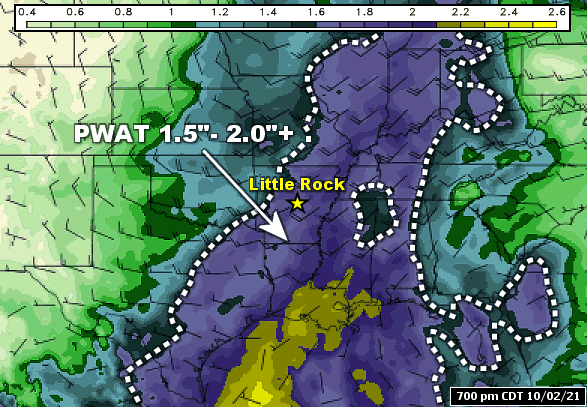
In the picture: Precipitable water (PWAT), or water vapor contained in a vertical column of the atmosphere, climbed to at least double the average over central and eastern Arkansas at 700 pm CDT on 10/02/2021. Typically in early October, values are between 0.75 and 1.00 inch. The image is courtesy of the College of DuPage.
Moisture levels were very high, and at least double the average. At the North Little Rock Airport (Pulaski County), precipitable water (or water vapor contained in a vertical column of the atmosphere) was around 1.90 inches at 700 am CDT on the 2nd. This was a Top 50 high value for October dating back to the 1940s, and well over a typical value between 0.75 and 1.00 inch. Given more than the usual moisture to wring out the of clouds, precipitation making efficiency was through the roof.
Some portions of northern Pulaski/Lonoke County have received more than 4-6 inches of rain. We're getting reports of flooded vehicles and at least a couple water rescues.
If you encounter flooded roadways, especially at night, please turn around and find a different route! #arwxpic.twitter.com/xhnyiQCz2H
In the picture: Several inches of rain during the evening of 10/02/2021 created dangerous driving conditions in parts of central Arkansas, with the darkness making if difficult to detect water across roads.
There were torrential downpours, with one report near Sherwood (Pulaski County) indicating 4.50 inches of rain dumped from 800 pm to 945 pm CDT. Because water was coming down faster than it could be carried away, drainage systems became overwhelmed. There were several reports of street flooding, with some vehicles stalled in high water and motorists rescued. South of Jacksonville (Pulaski County), the northbound lanes of U.S. Highway 67/167 were closed temporarily near U.S. Highway 440 as water covered the pavement. Three to four miles to the south, Fivemile Creek overflowed and turned nearby Silver Creek Drive into a lake.
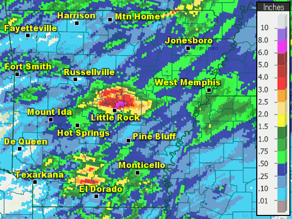
In the pictures: Twenty four hour precipitation through 700 am CDT on 10/03/2021. Most locations in Arkansas received less than a half inch of rain, with isolated amounts over two inches.
The deluge in central Arkansas was an isolated event. In fact, it was a feast or famine situation across the state, with big amounts in a few places and small totals at most locations. The largest rainfall reports were between North Little Rock and Jacksonville (both in Pulaski County), with six to more than eight inches of liquid measured.
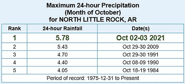
In the pictures: Wettest twenty four hour periods in October and all-time at the North Little Rock Airport (Pulaski County). The event on October 2-3, 2021, which resulted in 5.78 inches of rain, made both lists.
At the North Little Rock Airport (Pulaski County), 5.78 inches of rain fell on the 2nd/early on the 3rd. This was the wettest twenty four hour period at the site in October (dating back to 1975), and the fifth wettest such period all-time. Focusing on the 2nd alone, 5.25 inches of rain came down, which made it the second wettest calendar day locally (behind the high mark of 7.01 inches on November 18, 1988).
Other Localized Cloudbursts
While the sky was falling in central Arkansas, the same was happening (but not so heavy) to the south. Three to over four inches of precipitation was reported in parts of Calhoun and Ouachita Counties. In the twenty four hour period ending at 700 am CDT on the 2nd, there was just over six inches of water in a rain gauge near Buckner (Lafayette County), and four to five inches close to Bella Vista (Benton County). On the previous day (the 1st), radar estimated in excess of four inches of rain just to the southeast of Humnoke (Lonoke County).
Storm Reports
There were several reports of heavy rain and flash flooding in central Arkansas on October 2nd. For a look at the reports, click here.


 Follow us on YouTube