Are you interested in what happened during a recent event? Check out the report below.
Severe Storms on March 30, 2022
In the video: Simulated radar showed strong to severe thunderstorms building into western Arkansas during the predawn hours of 03/30/2022. Several Tornado Warnings were issued. There was a weakening trend during the morning, with storms becoming stronger toward the Mississippi River.
The writing was on the wall. There was not going to be an outbreak of severe weather on March 30th in Arkansas, mainly because of the timing of incoming storms. Typically, storms tend to thrive during the afternoon and early evening when the atmosphere is the most unstable due to daytime heating. This was mostly a late night/morning affair. While this calmed some nerves, we did not dodge a bullet entirely.
Here's a model supercell composite Tuesday night into Wednesday. The model lights up in Oklahoma (severe storm chances increasing), then not-so-much in Arkansas (severe storm chances decreasing), and again to the south/east. Data is courtesy of the College of DuPage.#arwxpic.twitter.com/smJKWt8NsY
In the video: Model supercell composite imagery showed the potential of supercells and severe weather increasing in Oklahoma late on 03/29/2022 and early the next morning. The potential went down across much of Arkansas through the early afternoon, and then increased farther south/east during the late afternoon and early evening. Data is courtesy of the College of DuPage.
The event kicked off with scattered severe storms (as well as isolated tornadoes) in the Plains from eastern Kansas to Texas on the 29th. Heading into the overnight hours, a Tornado Watch was issued at 1150 pm CDT, and this included portions of eastern Oklahoma and far northwest Arkansas (until 700 am CDT on the 30th).
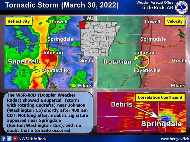
In the picture: The WSR-88D (Doppler Weather Radar) showed a supercell (storm with rotating updrafts) near Johnson (Washington County) shortly after 400 am CDT on 03/30/2022. Not long after, a debris signature appeared near Springdale (Benton/Washington Counties), with no doubt that a tornado occurred.
Just after 400 am CDT on the 30th, the situation became horrible from Johnson (Washington County) to Springdale (Benton/Washington Counties). A tornado (rated EF3/145 mph winds) was spawned, and caused extensive damage along a roughly five mile track. Homes and businesses were hit, as was a elementary school gymnasium and hangars at the airport in Springdale. Unfortunately, seven people were injured.
In the pictures: A cell tower was mangled and a business was destroyed by a tornado (rated EF3) at Springdale (Benton/Washington Counties) on 03/30/2022. The photos are courtesy of Brian Emfinger.
Farther south between 700 am and 800 am CDT, trees were downed along Highway 71 near Acorn (Polk County), with one tree on a mobile home. More trees were toppled at Harmony (Johnson County), and a chicken house lost some tin. A weak tornado (rated EF1) was responsible.
From there, not much happened for more than six hours as storms progressed to the east and weakened. At 1200 pm CDT, it was not overly warm with temperatures largely in the 50s and 60s and some lower 70s in central and eastern Arkansas. There were areas of heavy rain and a few rumbles of thunder, but that was about it.
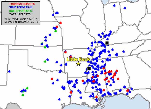
In the picture: Severe weather reports in the forty eight hour period ending at 700 am CDT on 03/31/2022. The graphic is courtesy of the Storm Prediction Center.
By 200 pm to 300 pm CDT, storms started intensifying again in eastern sections of the state. The roof of a museum was blown off at Lepanto (Poinsett County). A roof was removed from a mobile home at Dyess (Mississippi County), and siding was ripped from a home at Marie (Mississippi County). A semi truck was overturned on Interstate 55 around Burdette (Mississippi County). Utility poles were snapped in Marianna (Lee County). Photos indicated a tornado may have spun up near Snyder (Ashley County).
It got worse farther south/east in portions of Louisiana, western Tennessee, Mississippi, western Alabama, and the Florida panhandle. There were numerous reports of damaging winds and tornadoes.
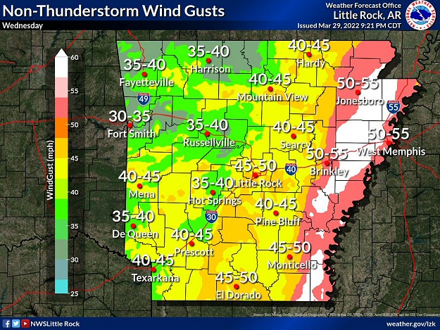
In the picture: The forecast called for non-thunderstorm wind gusts to exceed 50 mph in parts of eastern Arkansas on 03/30/2022.
Aside from thunderstorms on the 30th, it was a very windy day. Non-thunderstorm wind gusts (from the south) exceeded 50 mph in places (mainly northern and eastern Arkansas). There was a 58 mph gust at the Stuttgart Airport in Fairmount (Prairie County), a 52 mph gust at Jasper (Newton County), and 51 mph gust at Jonesboro (Craighead County).
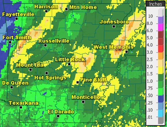
In the picture: Twenty four hour rainfall through 700 am CDT on 03/31/2022.
As far as rain, half inch to inch and a half amounts were common in the twenty four hour period ending at 700 am CDT on the 31st. There was locally more than two inches. Jasper (Newton County) received 3.00 inches of precipitation, with 2.43 inches at Mena (Polk County), 2.29 inches at Mountain Home (Baxter County), 2.23 inches at Blytheville (Mississippi County), 2.04 inches at Clarksville (Johnson County), and 2.02 inches at Flippin (Marion County) and Marianna (Lee County).
It turned colder by the morning of the 31st. At 1200 pm CDT, areas in far northwest Arkansas affected by the destructive tornado the day before had temperatures in the mid/upper 30s and light snow.
Storm Reports
There were isolated reports of severe weather in western Arkansas on March 30th (early). For a look at the reports, click here.


 Follow us on YouTube