 |
| Storm Reports |
| Are you interested in what happened during a recent event? Check out the report below. |
|
|
 |
Winter Storm on February 2-4, 2022 |
 |
| |
|
|
| |
|
It was a mild start to February, with temperatures peaking in the 60s to lower 70s on the 1st. That came to a crashing halt the next day as an Arctic air mass made its way into Arkansas from the northwest. Lots of moisture was available behind the front, and wintry precipitation became widespread.
|
|
|
| In the picture: Winter headlines were posted from the central and southern Rockies all the way to New England during the morning of 02/02/2022. |
|
| |
|
Heavy snow was in the forecast across northern into western sections of the state, with significant amounts of freezing rain and sleet farther south/east. Winter Storm Warnings and Ice Storm Warnings were posted for much of the region. Light accruals of ice/lesser impacts were expected in the far south where Winter Weather Advisories were in effect.
|
|
|
| In the picture: It was a foregone conclusion this wintry episode was going to happen because our resident fur-caster (Tarmac the Weather Cat) saw his shadow as Groundhog Day approached on 02/01/2022. |
|
| |
|
Precipitation type was based on the depth of the cold air surging into the area. The environment was subfreezing from the ground into the clouds in north/west (especially the Ozark Mountains), and this supported snow.
|
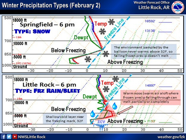 |
| In the picture: Soundings (temperature and dewpoint profiles with height) showed that snow was likely at Springfield, MO given an environment at/below freezing from the ground up at 600 pm CST on 02/02/2022. That was not the case at Little Rock, AR, with above freezing temperatures a few thousand feet aloft. Any snow would melt, and then refreeze in subfreezing air closer to the ground (resulting in freezing rain/sleet). |
|
| |
|
Elsewhere, there was a plume of above freezing temperatures overhead. Any snow falling into this warm layer melted, with refreezing near the ground (i.e. freezing rain and sleet) where thermometers showed readings at or below 32 degrees.
|
|
|
| In the video: Roads were snow covered and traffic was light in Mountain Home (Baxter County) during the evening of 02/03/2022. |
|
| |
|
By the evening of the 2nd, temperatures had dropped into the lower 20s in northwest Arkansas. There was a brief period of freezing rain/sleet in places, but the onset of snow was fairly quick, and flakes were flying through much of the 3rd. After a brief lull, one more round of light snow arrived from Oklahoma early on the 4th.
|
|
|
| In the picture: Trees were encased in a thick layer of ice in Gillett (Arkansas County) on 02/03/2022. The photo is courtesy of LeeAnn Morgan via Twitter. |
|
| |
|
From central into southern Arkansas, patchy light rain was noted at 900 pm CST on the 2nd, and temperatures were generally in the mid 30s to upper 40s. As it turned colder deeper into the night/early on the 3rd, the radar started showing more activity and it became icy.
|
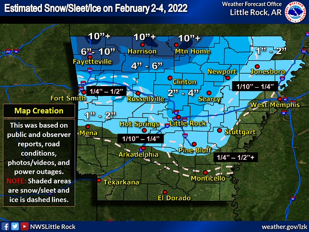 |
| In the picture: There was heavy snow in northwest Arkansas, and heavy sleet/some snow toward central sections of the state mainly on 02/03/2022 and early on the 4th. Across the west central, southern, and eastern counties, significant ice was noted in places. |
|
| |
|
By the time the event came to a close during the morning of the 4th, Lead Hill (Boone County) had 13 inches of snow, with 11 inches north of Bella Vista (Benton County), near Norfork (Baxter County), and west of Viola (Fulton County), 10 inches near Flippin (Marion County), and 8 inches close to Fayetteville (Washington County), Harrison (Boone County), and north of Mountain Home (Baxter County).
|
|
|
| In the picture: More than 20,000 power outages were counted in southern and eastern Arkansas during the afternoon of 02/03/2022. The information is courtesy of PowerOutage.us via Twitter. |
|
| |
|
Away from the Ozark Mountains and toward the central counties, one to more than three inches of sleet (and a little snow) was common. The southeast got the most freezing rain, with ice accruals of a half inch or more reported in spots from northwest of Monticello (Drew County) to De Witt (Arkansas County) and on toward Memphis, TN. Throw in a 15 to 25 mph north wind with higher gusts, and this stressed trees and power lines encased in ice. At least 25,000 power outages resulted.
|
|
|
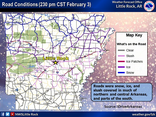
| |
|
Roads were snow, slush and ice covered across much of the state except the southern two rows of counties by the afternoon of the 3rd. Where roads were hazardous, temperatures were generally in the teens and 20s.
|
 |
| In the picture: Seventy two hour liquid precipitation totals through 600 am CST on 02/04/2022. |
|
| |
|
While the far south missed out on the wintry mess, there was beneficial rainfall. Three quarters of an inch to more than two inches of liquid precipitation was measured. Before the umbrellas came out, rain was below normal by nine to over eleven inches at El Dorado (Union County), Monticello (Drew County), and Texarkana (Miller County) from September, 2021 through January, 2022. The downpours during this event were sure to put a dent in an ongoing drought.
|
|
|
| In the picture: There was a swath of heavy snow from the southern Plains to Maine in the seventy two hour period ending at 600 am CST on 02/04/2022. |
|
| |
|
Beyond Arkansas, this event was far reaching. Ice and snow covered a lot of real estate in a swath from the central and southern Rockies all the way to New England. In the southeast United States, there was severe weather on the 3rd. A tornado (rated EF2) damaged homes in Sawyerville, AL. One woman was killed, and several people were seriously injured.
|
|
|
There were many reports of wintry precipitation (some heavy) on February 3rd/4th. For a look at the reports, click here.
|
| In the picture: Preliminary reports of wintry precipitation in the Little Rock County Warning Area on February 3-4, 2022 (in red). |
| |
|
|


 Follow us on YouTube