 |
| Storm Reports |
| Are you interested in what happened during a recent event? Check out the report below. |
|
|
 |
Severe Weather/Winter Storm on February 22-26, 2022 |
 |
| |
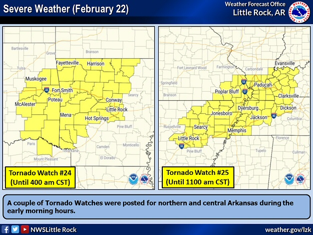 |
| In the picture: Tornado Watches were posted in much of northern and central Arkansas during the morning of 02/22/2022. |
|
| |
|
It was mild on February 22nd, with high temperatures in the 60s and 70s. It was 78 degrees at Monticello (Drew County) and Texarkana (Miller County), 77 degrees at Camden (Ouachita County), and 75 degrees at El Dorado (Union County). Springlike temperatures sometimes lead to severe weather this time of year, especially if there is a trigger nearby. In this case, a trigger in the form of a strong cold front was headed this way from the Plains.
|
 |
| Radar Image at 508 am CST (02/22) | Radar Loop (Video) |
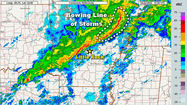
| In the picture/video: The WSR-88D (Doppler Weather Radar) showed a bowing line of thunderstorms tracking quickly through areas north and west of Little Rock (Pulaski County) and producing strong to damaging winds during the predawn hours of 02/22/2022. |
|
| |
|
Ahead of the front, a bowing line of thunderstorms swept through northern and western Arkansas during the early morning of the 22nd. The line got its backward C-shape from powerful winds forcing the line to bulge outward (to the east). Along its journey, the line was responsible for wind damage in places. Also, radar indicated a possible brief weak tornado between Bay and Otwell (both in Craighead County).
Trees were downed at Batesville (Independence County), Clinton (Van Buren County), Danville (Yell County), Fairfield Bay (Van Buren County), Marmaduke (Greene County), Prim (Cleburne County), and just north of Russellville (Pope County). Trees were on houses at Pocahontas (Randolph County) and Sedgwick (Lawrence County). A roof was torn off a barn at Hector (Pope County), with roofs removed from a duplex in Biggers, a couple of homes in Maynard, and a factory building in Pocahontas (all in Randolph County).
|
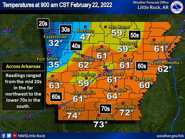 |
| In the picture: There was a huge temperature contrast across Arkansas at 900 am CST on 02/22/2022. Readings ranged from the mid 20s in the northwest to the lower 70s in the south. |
|
| |
|
After the storms exited, the aforementioned cold front surged through the state from the northwest. In the blink of an eye, winter was here. At 900 am CST, the mercury dropped to 25 degrees at Siloam Springs (Benton County), 32 degrees at Fayetteville (Washington County), and 35 degrees at Fort Smith (Sebastian County). Meanwhile, it was still spring temporarily in southern Arkansas, with several locations sitting in the lower 70s.
|
|
|
| In the picture: The sounding (temperature and dewpoint profile with height) showed that freezing rain was likely at North Little Rock (Pulaski County) at 600 pm CST on 02/23/2022. There was a warm layer aloft (temperatures above freezing/readings in the lower 50s at 5000 feet). Any snow would melt in this layer, and then refreeze in subfreezing air closer to the ground. |
|
| |
|
On the 23rd, subfreezing temperatures were in place in much of the region. But this was a shallow cold air mass, which means it only affected a slice of the atmosphere from the ground to a few thousand feet aloft. At 600 pm CST, while thermometers in the Little Rock (Pulaski County) area showed readings in the upper 20s and lower 30s, it was twenty degrees warmer (lower 50s) at 5000 feet. So, if there was any snow, it was going to melt overhead and then refreeze below (into freezing rain/sleet).
|
| Prolonged Cold |
|
The temperature at the North Little Rock Airport (Pulaski County) was at or below 32 degrees for four consecutive days (February 23rd through the 26th). While no records were set, it doesn't happen that often. A year ago, temperatures were subfreezing for nine straight days (February 10th through the 18th, 2021). The local record cold streak was twelve days in 1983 (December 19th through the 30th).
|
|
|
| In the video: Quite a few thunderstorms developed during this sleet/freezing rain event on 02/24/2022. Satellite picked up on some storms from central into northeast Arkansas during the predawn hours. Later in the morning, it happened again in northwest sections of the state. |
|
| |
|
There was plenty of moisture to play with behind the front. In fact, precipitation that developed (in at least two rounds on the 23rd/24th) was accompanied by thunder, and this bumped up the accumulation potential (heavy freezing rain/sleet).
|
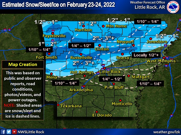 |
| In the picture: There was widespread sleet/freezing rain (and significant amounts of both) in much of northern and central Arkansas on February 23-24, 2022. |
|
| |
|
Appreciable sleet and freezing rain was confined to the northern and central counties through the 24th. There were significant accumulations reported. Joy (White County) had 5 inches of sleet, with 4 inches at London (Pope County) and Searcy (White County), and 3 inches at Adona (Perry County), Bradford (White County), Fifty Six (Stone County), near Floyd (White County), Hackett (Sebastian County), Hartman (Johnson County), Judsonia (White County), Oppelo (Conway County), and Sidney (Sharp County).
|
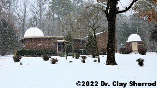 |
| In the picture: A period of heavy sleet (and some snow) was followed by freezing rain at Arkansas Sky Observatories at Petit Jean Mountain (Conway County) on February 23-24, 2022. By the time the event was over, walking was nearly impossible. The photo is courtesy of Dr. Clay Sherrod. Click to enlarge. |
|
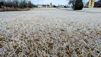 |
| In the picture: At the North Little Rock Airport (Pulaski County), this was largely a freezing rain event, with ice accruals just over a quarter inch on the trees and in the grass. Click to enlarge. |
|
| |
|
Ice accruals reached 0.75 inch at Cotton Plant (Woodruff County) and Mount Vernon (Faulkner County), 0.60 inch just east of Carlisle (Lonoke County), and 0.5 inch at Balch (Jackson County), Floral (Independence County), Greers Ferry (Cleburne County), Menifee (Conway County), Quitman (Cleburne County), Vilonia (Faulkner County), and Wynne (Cross County).
|
|
|
| In the video: Freezing rain turned Highway 67 into a skating rink near Newport (Jackson County) on 02/24/2022. The video is courtesy of Charles Peek via Twitter. |
|
| |
|
Whenever there is ice, travel can become a nightmare. One prime example happened during the morning of the 24th along Highway 67 at Newport (Jackson County). Not only were there numerous accidents, driving conditions were so treacherous that vehicles stopped in the middle of the road (a parking lot). Eventually, the highway was shut down.
|
|
|
| In the picture: More than 30,000 power outages were counted mainly from central into northeast Arkansas, and in parts of the Arkansas River Valley west of Little Rock (Pulaski County) during the evening of 02/24/2022. The information is courtesy of PowerOutage.us via Twitter. |
|
| |
|
More than 30,000 power outages were reported, with numerous outages in eastern Arkansas and in the Arkansas River Valley west of Little Rock (Pulaski County). This is where ice buildup on power lines was the most noteworthy, and where utility pole damage was the most extreme.
|
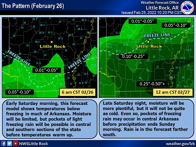 |
| In the picture: Pockets of freezing rain occurred in parts of central and southern Arkansas on 02/26/2022. |
|
| |
|
To add insult to injury, there was yet another small episode of ice on the 26th. Moisture was limited in the morning, but there was enough to yield pockets of light freezing rain in central and southern sections of the state. This led to some accidents, especially on bridges and overpasses. Moisture ramped up later in the afternoon/evening, but it was a little warmer. This time, the roads generally stayed wet, but there was some ice buildup in trees across central Arkansas.
|
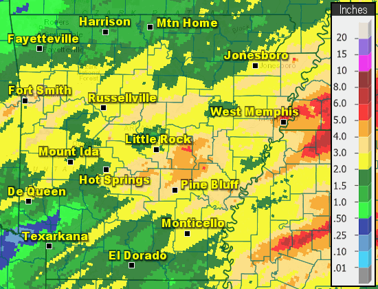 |
| In the picture: One hundred twenty hour (five day) liquid precipitation totals through 600 am CST on 02/27/2022. |
|
| |
|
Two to more than three inch liquid precipitation totals were common in much of the central third of the state in the five day period ending at 600 am CST on the 27th. In the far north and south, one to two inch amounts occurred. Even with the rain, precipitation was below normal by nine to over twelve inches at El Dorado (Union County), Monticello (Drew County), and Texarkana (Miller County) since September 1, 2021. Drought conditions continued across the south.
|
|
|
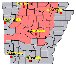
There were several reports of damaging winds across northern and western Arkansas during the morning of the 22nd. On the 23rd/24th, there were numerous instances of sleet and freezing rain in the northern half of the state. For a look at the reports, click here.
|
| In the picture: Preliminary reports of severe weather and wintry precipitation in the Little Rock County Warning Area on February 22-25, 2022 (in red). |
| |
|
|


 Follow us on YouTube