 |
| Storm Reports |
| Are you interested in what happened during a recent event? Check out the report below. |
|
|
 |
Snow on March 11, 2022 |
 |
| |
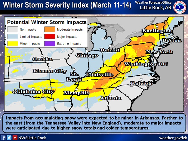 |
| In the picture: Impacts from accumulating snow on 03/11/2022 were expected to be minor in Arkansas. Farther to the east (from the Tennessee Valley into New England), moderate to major impacts were anticipated in the days to follow due to higher snow totals and colder temperatures. |
|
| |
|
There was talk about accumulating snow on March 11th, which was less than a week after eight tornadoes were counted in Arkansas. Much of the snow was expected on grassy areas, with roads becoming wet instead of white. Given few worries about travel, this was projected to be a low impact event.
|
 |
| Snow Timing (March 11) | Temperature/Weather Trends (March 11) |
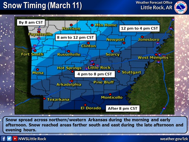
| In the pictures: Subfreezing temperatures were noted all day on 03/11/2022 in northwest Arkansas, with snow in the morning/early afternoon. Farther southeast, temperatures climbed into the 50s/60s, and then plummeted with snow in the late afternoon/evening. |
|
| |
|
If there were concerns about roads, they were focused in the northwest early in the day. That is because temperatures were already subfreezing, with readings in the mid 20s at Fayetteville (Washington County) and Harrison (Boone County) as of 900 am CST. At that time, flakes were flying at both locations. Snow stuck to the pavement, and there were accidents.
|
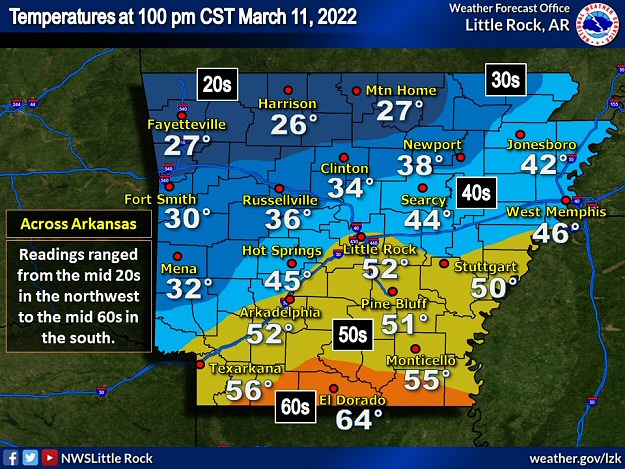 |
| In the picture: There was a large temperature contrast across Arkansas at 100 pm CST on 03/11/2022. Readings ranged from the mid 20s in the northwest to the mid 60s in the south. |
|
| |
|
Farther southeast, it was a much different story. By 100 pm CST, temperatures in central and southern Arkansas were in the 50s and 60s, and the sun was out. Highways and byways warmed up, and this led to melting once snow developed later in the afternoon. For frozen precipitation to occur, it had to cool down in a hurry, and it did.
At Little Rock (Pulaski County), the thermometer went from 52 degrees at 100 pm CST to the upper 30s a couple of hours later. A cold front plowed through the area, and north to northwest winds gusted from 25 to 35 mph. At 322 pm CST, snow began locally.
|
|
|
| In the video: A weather balloon was launched with snow falling (and accumulating) at the North Little Rock Airport around 500 pm CST on 03/11/2022. |
|
| |
|
Once the snow kicked in, it did not mess around (heavy at times). In fact, thunder accompanied the snow in places. While it generally lasted six hours or less, a lot of locations had several inches of heavy wet slush. At Little Rock (Pulaski County), snow ended at 844 pm CST after falling for five hours and twenty two minutes.
|
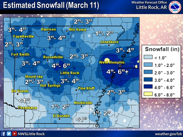 |
| In the picture: Estimated snowfall on 03/11/2022. Two to four inch accumulations were common across Arkansas, with one to two inch totals in the northeast and south. There were locally heavier amounts over five inches in central/east central sections of the state. |
|
| |
|
Five inches or more of snow piled up in central and east central sections of the state. Near Wynne (Cross County), 7 inches of accumulation was reported, with 5 to 6 inches at Perryville (Perry County), and 5 inches at Bismarck (Hot Spring County), Ferndale (Pulaski County), Morrilton (Conway County), and West Memphis (Crittenden County).
|
|
|
| In the video: After four to five inches of snow, Interstate 40 at Morrilton (Conway County) was mostly clear at 1100 pm CST on 03/11/2022. The video is courtesy of the Arkansas Department of Transportation via Twitter. |
|
| |
|
While this winter episode will not be remembered for paralyzing traffic, there was something interesting to mention. Usually, when it goes from mild to cold and there is snow in the forecast, precipitation begins as a prolonged period of rain. In this case, if there was rain, it was fleeting. Many folks mentioned no rain at all.
|
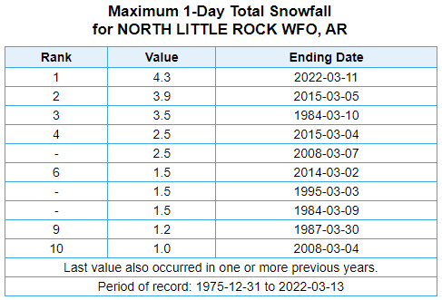 |
| In the picture: At the North Little Rock Airport (Pulaski County), the 4.3 inches of snow on 03/11/2022 was the heaviest one day March accumulation on record (dating back to 1975). |
|
| |
|
At the North Little Rock Airport (Pulaski County), there had never been so much snow in one day in March (dating back to 1975). The official measurement of 4.3 inches topped the previous monthly record of 3.9 inches on the 5th in 2015. Note that the event in 2015 set the high mark for the most snow in a twenty four hour period (spread over two days), with 6.3 inches of powder on the 4th/5th.
|
|
|
| In the video: The satellite showed snow melting quickly in eastern Arkansas and points east on 03/12/2022. The video is courtesy of the National Weather Service in Memphis, TN via Twitter. |
|
| |
|
There was little time to enjoy the snow. A strong March sun and temperatures in the 40s to lower 50s (except 30s in the northeast) on the 12th ate away at the snow in short order. Just as fast as the snow appeared, it vanished.
|
|
|
There were numerous reports of snow on March 11th/12th (early). For a look at the reports, click here.
|
| In the picture: Preliminary reports of snow in the Little Rock County Warning Area on March 11-12, 2022 (in red). |
| |
|
|


 Follow us on YouTube