
Dangerous and extreme heat will remain across portions of the central U.S. this week, persisting across the mid to lower Mississippi Valley, Gulf Coast, southern Plains and portions of Texas. A heat wave over the Southwest U.S. will peak this weekend. Heavy to excessive rainfall may produce flash flooding from the Delmarva Peninsula north into the Hudson Valley today and tonight. Read More >
Midland/Odessa
Weather Forecast Office
Significant snow accumulations accompanied a winter storm over west Texas on Tuesday, February 1st, 2005. The winter storm affected areas from the Davis Mountains northeast across the Upper Trans Pecos and the northwestern Permian Basin. The heaviest snow fell over the northwestern Permian Basin, where storm total snow accumulations piled up to seven inches. The storm caused dangerous driving conditions and contributed to several roll-over vehicle accidents.
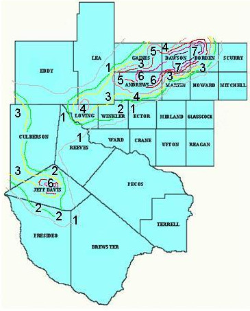
The figure shows storm total snow accumulations resulting from the February 1, 2005, winter storm in west Texas.
On Sunday, January 30th, the National Weather Service Forecast Office in Midland/Odessa issued a Winter Storm Outlook mentioning the potential for a significant winter storm on Tuesday. A Winter Storm Watch was posted for Tuesday early on Monday, January 31st, and was upgraded to a Winter Storm Warning by late that afternoon.
Light rain and drizzle transitioned to snow over the mountains of west Texas late Monday evening. Wintry precipitation then spread from west to east across the area through the pre-dawn hours Tuesday. By mid morning, a narrow band of heavy snow developed over the Upper Trans Pecos region of west Texas and stretched northeast across the northwestern Permian Basin. Snow quickly accumulated to significant depths beneath this heavy snow band as it persisted over Andrews, Dawson, Gaines, and northwestern Borden Counties through midday. Relatively warm ground temperatures helped to limit snow accumulations over much of the area, however, six to seven inch accumulations were common across the northwestern portions of the Texas Permian Basin.
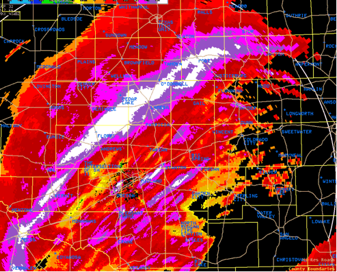
Radar image from the Midland, Texas, 88D Doppler radar showing the enhanced band of heavy snowfall over the northwestern Permian Basin at 10:17 AM CST.
Hazards
Spotter Briefing
Outlook
Current Hazards
Storm Report
Severe Weather
Drought
Storm Prediction Center
Weather Prediction Center
National Hurricane Center
Active Alerts
Winter Weather
Past Weather
Cooperative Observations
Local Climate Data
National Climate
Current Weather
Observations
Satellite
Upper Air
West Texas Mesonet
Radar
Forecasts
Activity Planner
Aviation
Climate Prediction Center
Fire
Forecast Discussion
Graphical
Local
Space Weather Center
Information Center
Weather Trivia
Forecast Models
GIS
International Weather
Glossary
Road Conditions
Water
Hydrology
Precipitation Estimates
Quantitative Precipitation Forecasts
US Dept of Commerce
National Oceanic and Atmospheric Administration
National Weather Service
Midland/Odessa
2500 Challenger Dr.
Midland, TX 79706-2606
(432) 563-5006
Comments? Questions? Please Contact Us.

