
Dangerous and extreme heat will remain across portions of the central U.S. this week, persisting across the mid to lower Mississippi Valley, Gulf Coast, southern Plains and portions of Texas. A heat wave over the Southwest U.S. will peak this weekend. Heavy to excessive rainfall may produce flash flooding from the Delmarva Peninsula north into the Hudson Valley today and tonight. Read More >
Midland/Odessa
Weather Forecast Office
A severe thunderstorm packing golf ball size hail and wind gusts of 60 mph impacted Hobbs, New Mexico and western Gaines county in Texas during the afternoon hours on May 10, 2005. Golf ball size hail was reported in Hobbs at 4:34 pm MDT. Strong winds also accompanied this storm and many broken windows were reported around the city. As this storm moved northeast into western Gaines county, severe winds downed power lines near the intersection of county road 210 and Farm to Market road 3306.
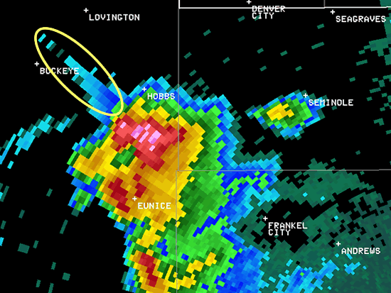
This radar image shows a severe thunderstorm just south of Hobbs, New Mexico at 4:30 pm MDT on May 10, 2005. The feature circled in the above image is known as a three body scatter spike, or hail spike and indicates the presence of hail within the storm.
Hazards
Spotter Briefing
Outlook
Current Hazards
Storm Report
Severe Weather
Drought
Storm Prediction Center
Weather Prediction Center
National Hurricane Center
Active Alerts
Winter Weather
Past Weather
Cooperative Observations
Local Climate Data
National Climate
Current Weather
Observations
Satellite
Upper Air
West Texas Mesonet
Radar
Forecasts
Activity Planner
Aviation
Climate Prediction Center
Fire
Forecast Discussion
Graphical
Local
Space Weather Center
Information Center
Weather Trivia
Forecast Models
GIS
International Weather
Glossary
Road Conditions
Water
Hydrology
Precipitation Estimates
Quantitative Precipitation Forecasts
US Dept of Commerce
National Oceanic and Atmospheric Administration
National Weather Service
Midland/Odessa
2500 Challenger Dr.
Midland, TX 79706-2606
(432) 563-5006
Comments? Questions? Please Contact Us.

