
Flash flooding threatens areas from the Tennessee Valley to the Carolinas as storms repeat along a stalled front. Monsoonal storms may trigger flooding in the Southwest. Dangerous heat expands across the Desert Southwest, Plains, mid-Mississippi Valley and Southern Tier. Critical fire weather for interior Pacific Northwest. Cooler, drier air brings brief relief to the Great Lakes and Northeast. Read More >
Midland/Odessa
Weather Forecast Office
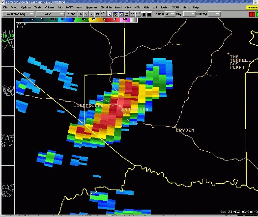
Sanderson Severe Weather July 4
A severe thunderstorm produced damaging winds that blew down large circus-style tents, severely damaged a trailer home, blew trees into power lines, and damaged other light weight objects in Sanderson (Terrell County, Texas) Sunday evening. The large tents were part of a Fourth of July celebration. Seven minor injuries were reported as a result of the damage at the festival.
The National Weather Service in Midland/Odessa issued a Severe Thunderstorm Warning that specifically mentioned a threat of "destructive winds in excess of 70 MPH" for the city of Sanderson at 6:29 PM CDT. The warning was updated with a Severe Weather Statement at 6:38 PM CDT emphasizing "This is a dangerous storm. Prepare immediately for damaging winds and perhaps hail..."
The Terrell County Sheriff's Office reported that damaging winds and hail up to the size of quarters began at 6:55 PM CDT. These reports indicate that the Severe Thunderstorm Warning provided Sanderson officials and residents a 26 minute lead time before the onset of the damaging winds and hail.
Radar image of the severe thunderstorm over Sanderson minutes before severe winds and hail caused damage and injuries at a large Fourth of July celebration.
Hazards
Spotter Briefing
Outlook
Current Hazards
Storm Report
Severe Weather
Drought
Storm Prediction Center
Weather Prediction Center
National Hurricane Center
Active Alerts
Winter Weather
Past Weather
Cooperative Observations
Local Climate Data
National Climate
Current Weather
Observations
Satellite
Upper Air
West Texas Mesonet
Radar
Forecasts
Activity Planner
Aviation
Climate Prediction Center
Fire
Forecast Discussion
Graphical
Local
Space Weather Center
Information Center
Weather Trivia
Forecast Models
GIS
International Weather
Glossary
Road Conditions
Water
Hydrology
Precipitation Estimates
Quantitative Precipitation Forecasts
US Dept of Commerce
National Oceanic and Atmospheric Administration
National Weather Service
Midland/Odessa
2500 Challenger Dr.
Midland, TX 79706-2606
(432) 563-5006
Comments? Questions? Please Contact Us.

