
A Nor'easter will create hazardous marine and coastal conditions along the Mid-Atlantic coast through mid-week, with significant coastal flooding and beach erosion possible. Meanwhile, another strong storm system is forecast to bring high winds and heavy precipitation to portions of southern Alaska. Elsewhere, relatively benign weather is expected through the first half of the work week. Read More >
Midland/Odessa
Weather Forecast Office
January 16, 2007 Heavy Snow
A winter storm moving across the area Tuesday evening and overnight resulted in significant snowfall across portions of southeast New Mexico, southwest Texas, the Trans-Pecos Region, and the Permian Basin.
The graphic below shows the total snow accumulations from yesterday evening and overnight.
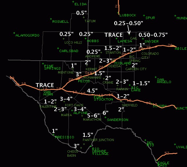
Morning reports from across the area also indicated that Interstate 10 was closed from Fort Stockton to San Antonio. Highway 90 was closed from the eastern Terrell County line to Del Rio. Highway 67 was closed from Marfa to Presidio. Hazardous driving conditions were also noted along the Loving and Winkler County line.
Hazards
Spotter Briefing
Outlook
Current Hazards
Storm Report
Severe Weather
Drought
Storm Prediction Center
Weather Prediction Center
National Hurricane Center
Active Alerts
Winter Weather
Past Weather
Cooperative Observations
Local Climate Data
National Climate
Current Weather
Observations
Satellite
Upper Air
West Texas Mesonet
Radar
Forecasts
Activity Planner
Aviation
Climate Prediction Center
Fire
Forecast Discussion
Graphical
Local
Space Weather Center
Information Center
Weather Trivia
Forecast Models
GIS
International Weather
Glossary
Road Conditions
Water
Hydrology
Precipitation Estimates
Quantitative Precipitation Forecasts

US Dept of Commerce
National Oceanic and Atmospheric Administration
National Weather Service
Midland/Odessa
2500 Challenger Dr.
Midland, TX 79706-2606
(432) 563-5006
Comments? Questions? Please Contact Us.


 Follow us on X
 Follow us on Facebook
 MAF RSS Feed