
Flash flooding threatens areas from the Tennessee Valley to the Carolinas as storms repeat along a stalled front. Monsoonal storms may trigger flooding in the Southwest. Dangerous heat expands across the Desert Southwest, Plains, mid-Mississippi Valley and Southern Tier. Critical fire weather for interior Pacific Northwest. Cooler, drier air brings brief relief to the Great Lakes and Northeast. Read More >
January 28, 2008 High Winds and Wildfires
A potent upper level storm system brought very windy conditions to the region. The combination of the tight surface pressure gradient and strong wind speeds aloft has resulted in very windy conditions across west Texas and southeast New Mexico.
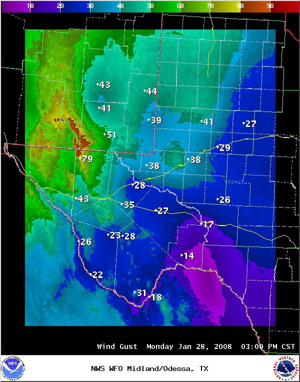
The following graphic shows wind gusts reported across the region as of 3 pm CST (2 pm MST) - Note the wind gust of 79 mph at Guadalupe Pass!
Strong winds, decreasing relative humidity, and very dry and dormant vegetation across the region will keep fire danger elevated for the remainder of this afternoon. A large wildfire has already been reported in northern Martin county. This wildfire is very well visible from the NWS Midland doppler radar, as seen in this image from 3:45 pm CST:
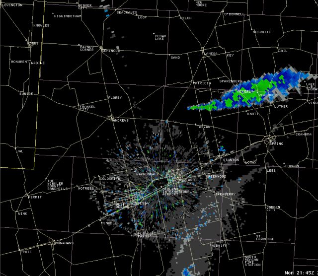
This wildfire will likely impact persons along and near farm to market roads 828 and 2002, and state highways 137 and 349 in northern Martin county.
A High Wind Warning was issued for the plains of Eddy county New Mexico until 5 pm CST. Local spotters and area observations have reported sustained southwesterly wind speeds of 40-45 mph, with gusts near 60 mph in the Carlsbad and Lakewood areas.
A Wind Advisory was issued for all of the Permian Basin until 6 pm CST for expected southwesterly wind speeds of 30-35 mph, with occasional gusts over 45 mph. These winds should gradually diminish after sunset.
A High Wind Warning was in effect through Tuesday morning across the Guadalupe and Davis Mountains. Look for strong west to southwest winds of 40-55 mph, with occasional gusts near 75 mph in the Guadalupe Mountains...with west to southwest winds of 30-40 mph, and gusts over 55 mph in the Davis mountains.
A pacific cold front will pass from west to east across the region. Winds will shift to the west/northwest following the passage of this front. Wind speeds of 30-35 mph, with gusts near 45 mph will likely persist through the night into Tuesday morning across the southeast New Mexico plains, the Van Horn Corridor, and the upper trans Pecos region. The Wind Advisory for these locations has been extended until 8 am CST (7 am MST) Tuesday morning.
Drier air spreading southeastward across the region will combine with breezy northwest winds to produce continued elevated fire danger across the entire region.

