
Dangerous and extreme heat will remain across portions of the central U.S. this week, persisting across the mid to lower Mississippi Valley, Gulf Coast, southern Plains and portions of Texas. A heat wave over the Southwest U.S. will peak this weekend. Heavy to excessive rainfall may produce flash flooding from the Delmarva Peninsula north into the Hudson Valley today and tonight. Read More >
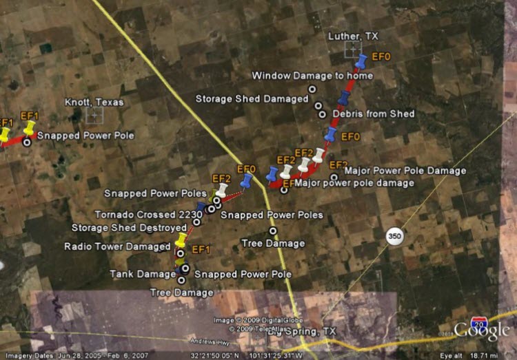
On Friday, April 17, 2009, the National Weather Service in Midland conducted a damage survey for a tornado that occurred across the northern portions of Howard county during the evening of Thursday, April 16.
During the late afternoon and evening of Thursday, April 16, scattered to numerous thunderstorms developed across portions of west Texas, and moved northeastward across the area. Some of these thunderstorms exhibited supercellular characteristics, and resulted in the development of several significant tornadoes and large hail across portions of the Texas Permian Basin.
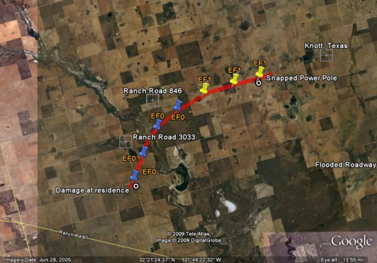
The following is not a comprehensive mapping of all tornadoes that developed across the WFO Midland area Thursday, but rather the results and evaluation of the three most significant tornado tracks, as found in our post-event damage survey conducted over portions of Martin and Howard counties. The tracks indicated on the map are the approximate path that these tornadoes took based on damage found by the WFO Midland post-event survey team. In many cases, the most significant damage was found just to the right of the indicated path.
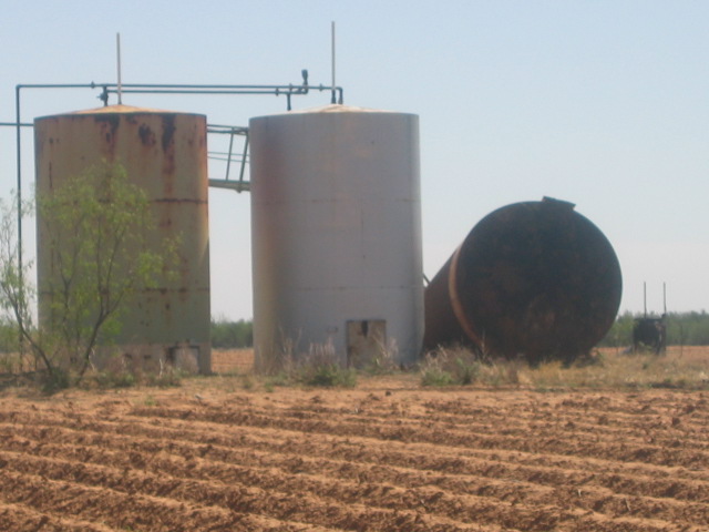
On Thursday evening, a National Weather Service employee reported a brief tornado approximately 7.25 miles south southeast of Tarzan near Farm to Market 1212. Based on radar data, this brief tornado touchdown was from the same supercell thunderstorm that eventually produced the Howard County tornadoes later in the evening. Along County Road 17, the National Weather Service survey team found tornado damage that is believed to be from the beginning stages of the first Howard County tornado. Along this road, a large tank was damaged and two power poles were snapped. Each of these fell to the east southeast, which suggests that the initial tornado formation was directly to the west in a nearby field.
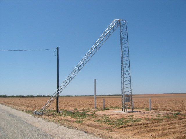
Farther to the north along County Road 17, a radio tower (approximately 80 feet in height) was bent from near its mid point to the ground. Based on the size and strength of of the tower, this is indicative of high-end EF1 damage - a high end "weak" tornado - with winds estimated at just over 100 mph. As the tornado moved northeastward, a small storage shed was pulled from the ground and tossed approximately 30 yards (high end EF0 damage). While the tornado crossed Farm to Market Road 2230, west of Fairview and Highway 87 (Lamesa Highway), it snapped two power poles near the ground. Eye witness reports estimated the width of the tornado at greater than 1/4 mile wide. Power pole damage along County Road 21 just north of FM2230 confirmed this estimate, with the tornado width estimated at approximately 500 yards. Pole damage at this location, with the poles sheared at their bases, were that of low end EF2 damage - the lower end of strong tornado intensity based on the enhanced Fujita scale. The NWS survey team did not find a conclusive crossing point on Highway 87. Thus, primary indications are that this tornado dissipated in a field west of Highway 87 near Fairview, then rapidly re-developed east of Highway 87.
East of Highway 87, the second Howard County tornado travelled east northeast, along and just to the north of Farm to Market 2230. This resulted in 20 distribution poles and 8 larger transmission power poles being snapped by strong northwest to north winds. This damage was also that of EF2 intensity on the tornado intensity scale - with winds estimated in the 115-125 mph range. The tornado then weakened to EF0 intensity as it began to move northeastward before finally dissipating just south of the community of Luther.
Click the image above to explore the damage further using Google Earth.
This tank was damaged and fell to the east.
A radio tower estimated at 80 feet in height was bent in half due to high winds
A 12'x10' storage shed anchored 2-3 feet in the ground was destroyed due to high winds and tossed east northeast approximately 30 yards.
This marked the southern extent of power pole damage where the tornado crossed County Road 21.
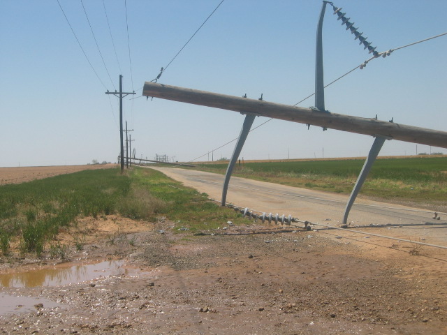
This location marked the eastern extent of power pole damage east of Highway 87 along Farm to Market Road 2230. The transmission poles were located farther to the east than the distribution poles. While much larger than the distribution poles, they were also made of wood.
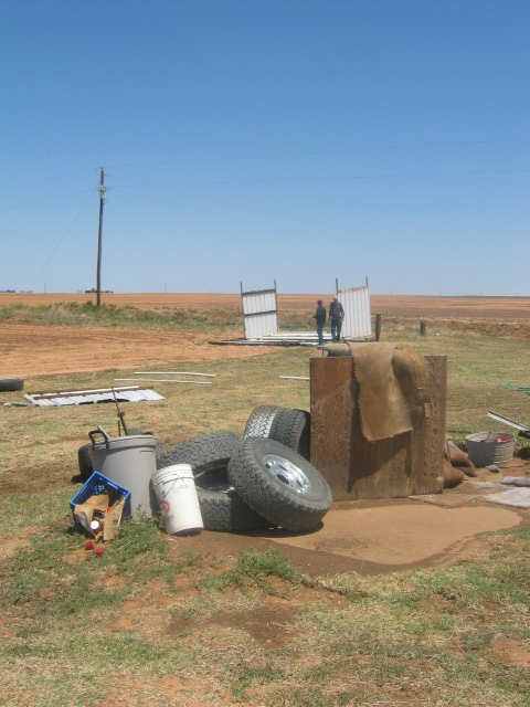
The other tornado track investigated by the survey team occurred in Martin County. A residence along Farm to Market Road 3033 sustained EF0 type tornado damage as a tornado moved just to the northwest of thier location. The tornado eventually began to track more east northeastward - paralleling Ranch Road 846. As the tornado crossed County Road 7 along the Martin and Howard County line, it intensified to EF1 intensity - snapping two power poles. The tornado eventually crossed into northwest portions of Howard County, dissipating just southwest of the community of Knott.
While not investigated in a formal survey, other EF0 type tornado damage was noted in the Vincent area, as well as near Lake J.B. Thomas.
Click the image above to explore the damage further using Google Earth.
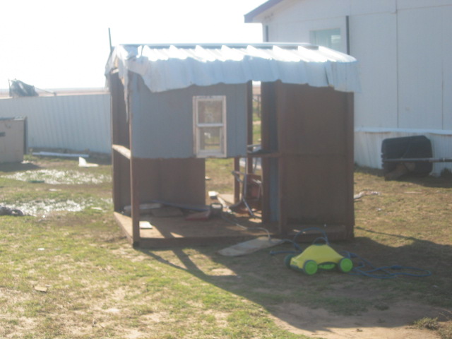
A small storage shed was damaged and blown approximately 20 yards to the east.
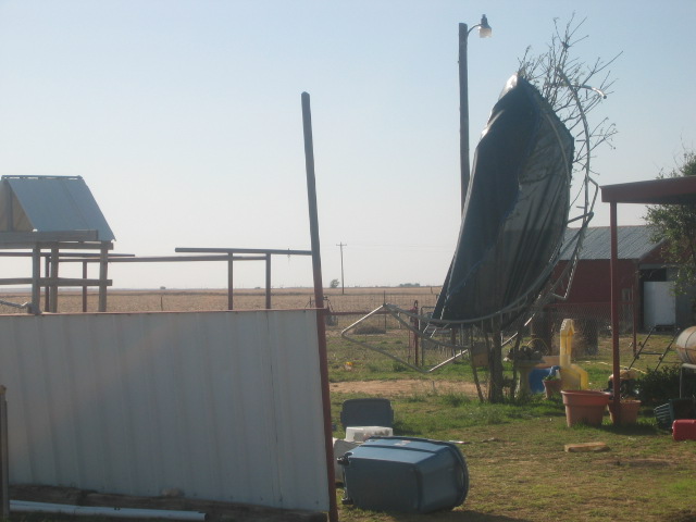
Also, a trampoline was wrapped around a nearby tree. The home appears to have sustained some wind damage as well, with damaging west winds.
PRELIMINARY LOCAL STORM REPORT...SUMMARY
NATIONAL WEATHER SERVICE MIDLAND/ODESSA TX
317 PM CDT SAT APR 18 2009
..TIME... ...EVENT... ...CITY LOCATION... ...LAT.LON...
..DATE... ....MAG.... ..COUNTY LOCATION..ST.. ...SOURCE....
..REMARKS..
0455 PM HAIL GAIL 32.77N 101.45W
04/16/2009 E0.75 INCH BORDEN TX EMERGENCY MNGR
DIME TO PENNY HAIL
0515 PM HAIL GAIL 32.77N 101.45W
04/16/2009 E1.25 INCH BORDEN TX PUBLIC
0525 PM HAIL 5 NE MIDLAND 32.05N 102.02W
04/16/2009 E0.75 INCH MIDLAND TX PUBLIC
0530 PM HAIL 18 NE GAIL 32.95N 101.23W
04/16/2009 E1.50 INCH GARZA TX TRAINED SPOTTER
NICKEL TO ALMOST GOLF BALL HAIL
0530 PM HAIL 13 NE GAIL 32.90N 101.29W
04/16/2009 E1.00 INCH BORDEN TX TRAINED SPOTTER
0541 PM HAIL STANTON 32.13N 101.79W
04/16/2009 E0.88 INCH MARTIN TX PUBLIC
0548 PM HAIL STANTON 32.13N 101.79W
04/16/2009 E0.75 INCH MARTIN TX PUBLIC
0604 PM HAIL MIDLAND 32.00N 102.08W
04/16/2009 E0.50 INCH MIDLAND TX NWS EMPLOYEE
.25 TO .5 INCH HAIL
0615 PM HAIL 10 W MIDLAND 32.00N 102.25W
04/16/2009 E0.50 INCH MIDLAND TX PUBLIC
.25 TO .5 INCH HAIL
0704 PM HAIL GARDENDALE 32.02N 102.37W
04/16/2009 E1.00 INCH ECTOR TX TRAINED SPOTTER
0800 PM HAIL LENORAH 32.31N 101.88W
04/16/2009 E1.00 INCH MARTIN TX PUBLIC
0810 PM HAIL LENORAH 32.31N 101.88W
04/16/2009 E1.50 INCH MARTIN TX TRAINED SPOTTER
0815 PM HAIL LENORAH 32.31N 101.88W
04/16/2009 E1.00 INCH MARTIN TX TRAINED SPOTTER
0830 PM HAIL 8 E FLOWER GROVE 32.50N 101.75W
04/16/2009 E2.75 INCH MARTIN TX PUBLIC
GOLF BALL TO BASEBALL HAIL
0830 PM HAIL 8 E FLOWER GROVE 32.50N 101.75W
04/16/2009 E1.75 INCH MARTIN TX PUBLIC
0849 PM HAIL W TARZAN 32.31N 101.98W
04/16/2009 E0.88 INCH MARTIN TX NWS EMPLOYEE
0850 PM HAIL 5 S ANDREWS 32.25N 102.55W
04/16/2009 E1.00 INCH ANDREWS TX TRAINED SPOTTER
0853 PM TORNADO 5 NW BIG SPRING 32.30N 101.54W
04/16/2009 HOWARD TX TRAINED SPOTTER
0905 PM TORNADO FAIRVIEW 32.36N 101.52W
04/16/2009 HOWARD TX TRAINED SPOTTER
0925 PM TSTM WND DMG S VINCENT 32.48N 101.23W
04/16/2009 HOWARD TX TRAINED SPOTTER
60 FT TOWER BLOWN DOWN, BASE TWISTED 180 DEGREES - WCR 17
TOWARD 2230 N 1 AND A HALF MILES SOUTH IN HOWARD COUNTY
0930 PM HAIL 15 N CRANE 31.61N 102.35W
04/16/2009 E1.75 INCH CRANE TX TRAINED SPOTTER
0930 PM HAIL 2 E LENORAH 32.31N 101.85W
04/16/2009 E0.88 INCH MARTIN TX NWS EMPLOYEE
0945 PM HAIL 13 NE GAIL 32.90N 101.29W
04/16/2009 E1.00 INCH BORDEN TX TRAINED SPOTTER
1025 PM HAIL BIG SPRING 32.25N 101.48W
04/16/2009 E0.88 INCH HOWARD TX TRAINED SPOTTER
1027 PM HAIL BIG SPRING 32.25N 101.48W
04/16/2009 E1.00 INCH HOWARD TX TRAINED SPOTTER
1030 PM HAIL BIG SPRING 32.25N 101.48W
04/16/2009 E1.00 INCH HOWARD TX TRAINED SPOTTER
1030 PM HAIL 7 W BAKERSFIELD 30.89N 102.42W
04/16/2009 E1.00 INCH PECOS TX DEPT OF HIGHWAYS
1030 PM HAIL 7 W BAKERSFIELD 30.89N 102.42W
04/16/2009 E1.00 INCH PECOS TX LAW ENFORCEMENT
1033 PM HAIL 2 N BIG SPRING 32.28N 101.48W
04/16/2009 E1.00 INCH HOWARD TX TRAINED SPOTTER
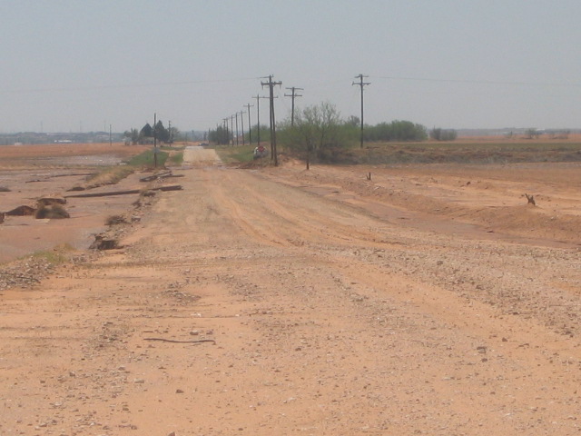
1036 PM FLASH FLOOD 11 NW BIG SPRING 32.36N 101.61W
04/16/2009 HOWARD TX LAW ENFORCEMENT
4 FEET OF WATER OVER FM 2230, HIGHWAY IS WASHED OUT, DPS
IS CLOSING ROAD
1045 PM HAIL 43 E FORT STOCKTON 30.89N 102.16W
04/16/2009 E0.88 INCH PECOS TX LAW ENFORCEMENT
PENNY TO NICKEL HAIL
1052 PM HAIL COAHOMA 32.29N 101.31W
04/16/2009 E1.00 INCH HOWARD TX TRAINED SPOTTER
1135 PM HAIL WESTBROOK 32.36N 101.01W
04/16/2009 E1.00 INCH MITCHELL TX FIRE DEPT/RESCUE
1230 AM FLASH FLOOD 1 W COLORADO CITY 32.40N 100.88W
04/17/2009 MITCHELL TX LAW ENFORCEMENT
SERVICE ROAD BETWEEN PRISON AND RIVER BRIDGE COMPLETELY
INUNDATED.

