National Weather Service United States Department of Commerce

Strong Spring Storm to Bring Widespread Hazardous Weather to the Central U.S.

A strong Spring storm system will bring blizzard conditions from the central High Plains to the Upper Midwest Wednesday while severe thunderstorms are possible in the Midwest. Gusty winds and dry conditions will continue critical fire weather Wednesday into Friday from southwestern Texas into the southern High Plains. Read More >

Another day of very windy conditions is expected across Southeast New Mexico and West Texas from this morning through the evening. The strongest of these winds are expected over the Guadalupe and Davis Mountains and adjacent plains. These winds may blow around unsecured objects and make driving difficult, especially with blowing dust reducing visibility.
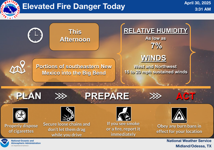
The combination of extremely low relative humidity (as low as 5 percent), strong westerly winds, and high to extreme fire danger will result in favorable conditions for rapid fire growth and spread over the area today. A Red Flag warning has been issued for all of West Texas and Southeast New Mexico for this afternoon and evening.
Strong winds will once again kick up dust across Southeast New Mexico and much of West Texas. A Blowing Dust Advisory has therefore been issued for much of the area from late this morning through the evening and a Blowing Dust Warning for Culberson County into Southeast New Mexico. Visibilities are expected to drop below 3 miles for these locations, with some local reductions to near-zero visibility.
Gusty westerly winds are expected today across much of the area, with the strongest winds expected in Southeast New Mexico and in the Guadalupe/Delaware and Davis Mountains. Use caution if traveling today, especially if driving a high profile vehicle! Also be aware of blowing dust, which could locally drop visibilities to near-zero!
The combination of extremely low relative humidity (as low as 4 percent), gusty northwesterly winds, and high fire danger will result in favorable conditions for rapid fire growth and spread over the area today. A Fire Weather Watch has been issued for all of Southeast New Mexico and much of West Texas Wednesday morning through Wednesday evening.
Highs in the 80s are forecast for today, with even some 90s expected for the eastern Permian Basin and Lower Trans-Pecos! A cold front tonight will allow for cooler temperatures Wednesday, with most locations seeing highs in the 60s (and some 70s along the Rio Grande).

Text Product Selector (Selected product opens in current window)
Submit Storm Report Spotter Briefing Skywarn Storm Data Tornado Statistics Social Media
Storm Reports Spotter Briefing Storm Spotters Storm Data Tornado Statistics Social Media
 
Area Forecast Discussion Hourly Forecast Graphs Digital Forecasts Fire Weather Aviation Hydrology
Forecast Discussion Hourly Forecast Graphical Forecast Fire Weather Aviation Hydrology
 
Observations Air Quality Satellite Climate Past Events weather Radio
Observations Air Quality Satellite Climate Past Events Weather Radio