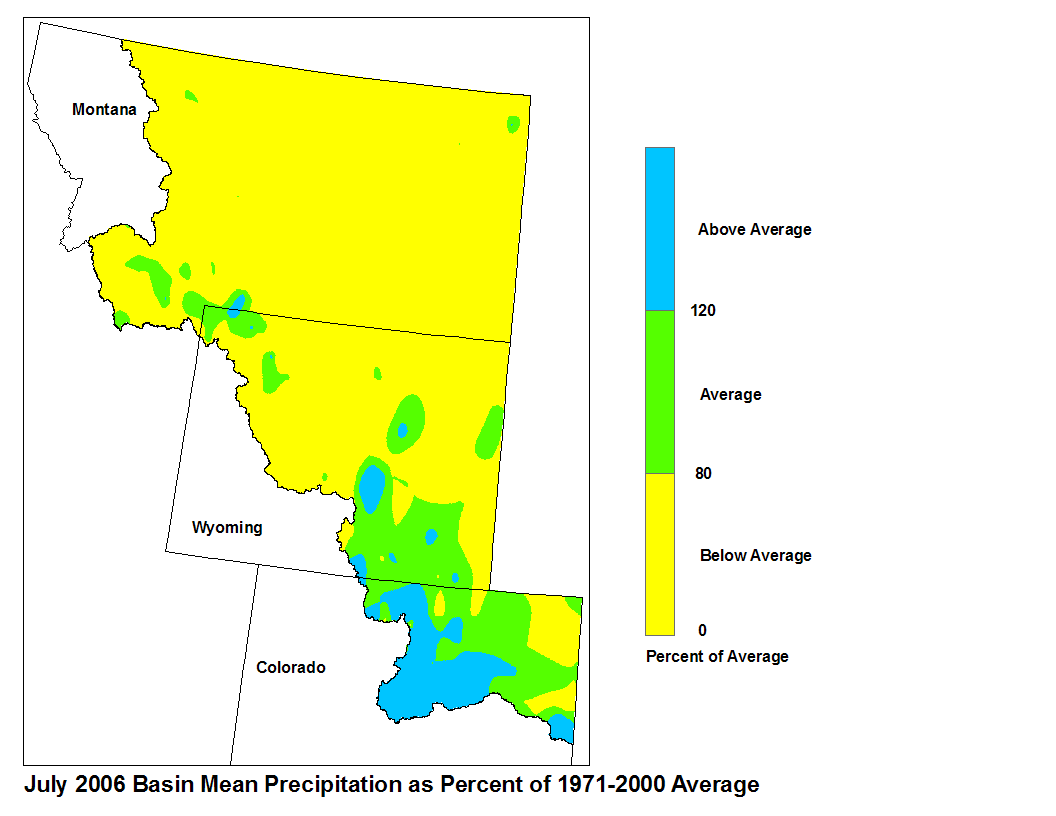
Most of the Missouri River Basin reported below average precipitation
during the month of July, with the exception of the South Platte
basin where above average precipitation fell. Also, streamflow
data indicates the flows for the month of July were below average.
Precipitation in the Missouri River Basin during July ranged from below
average to above average, with the northern portion of the basin
reporting below average precipitation. Precipitation in Montana was
generally below average, with amounts ranging from a 0 percent of
average (0.0 in.) at several locations across the state to 152 percent of
average (3.20 in.) at Monument Park, Montana. Precipitation
in Wyoming was generaly below average with reports ranging from
0 percent of average (0.00 in.) at several locations across the state
to 232 percent of average (2.11 in.) at Alcova 14 mi SW, Wyoming.
Precipitation in northeastern Colorado was generally above average,
with reports ranging from 35 percent of average (0.60 in.) at
Trapper Lake, Colorado to 356 percent of average (5.70 in.)
at Porphyry Lake, Colorado.
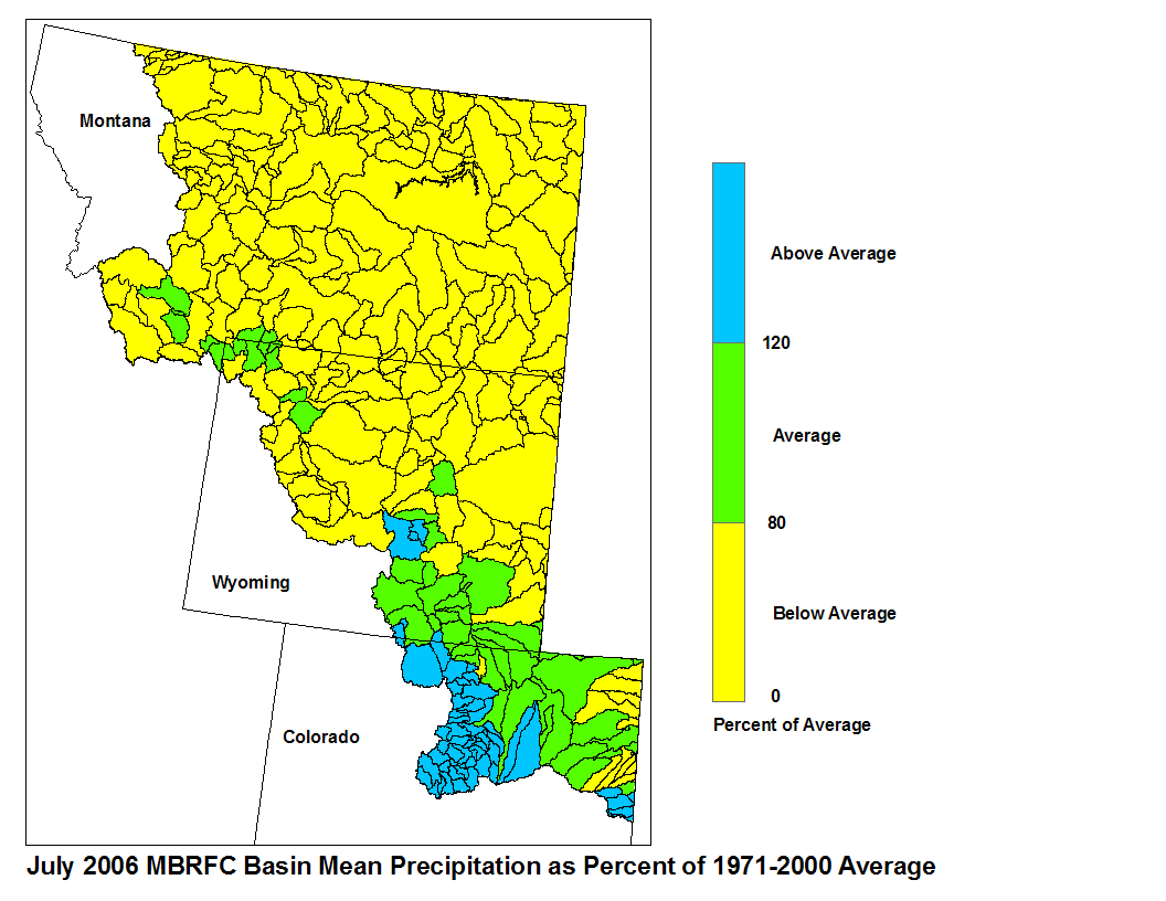
Basin precipitation summaries for the Missouri Basin:
Basin Average Precipitation
Milk St. Mary 31%
Milk Canada 13%
Above Toston 65%
Toston to Ft. Peck 32%
Lower Milk 24%
Upper Yellowstone 58%
Wind River 40%
Bighorn 41%
Little Bighorn Tongue 34%
Powder 44%
Lower Yellowstone 30%
Upper North Platte 108%
Lower North Platte 85%
South Platte Mountains 169%
South Platte Plains 106%
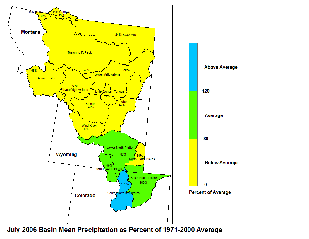
July 2006 Basin Mean Precipitation
Stored water in the South Platte Basin as of August 1 was 76 percent of average for this time of the year. Of the four major irrigation reservoirs in Montana, Lima Reservoir had 134 percent average storage; Clark Canyon was holding 53 percent of average water, Gibson Reservoir had 46 percent of average stored water and Fresno Reservoir had 79 percent of average stored water. Of the three major hydroelectric reservoirs in Montana, Canyon Ferry and Fort Peck had monthend storage in the average range; 98 and 58 percent of average water, respectively. Bighorn reservoir was holding 74 percent of average stored water. Runoff during July, as indicated by U.S. Geological Survey long term gaging stations, was below average. The Marias River near Shelby, Montana had 42 percent of average runoff. The Yellowstone River was estimated to have had 63 percent of average runoff at Corwin Springs, while at Billings, Montana runoff was 47 percent of average.