National Weather Service United States Department of Commerce

Areas of Excessive Rainfall and Severe Thunderstorms for Friday

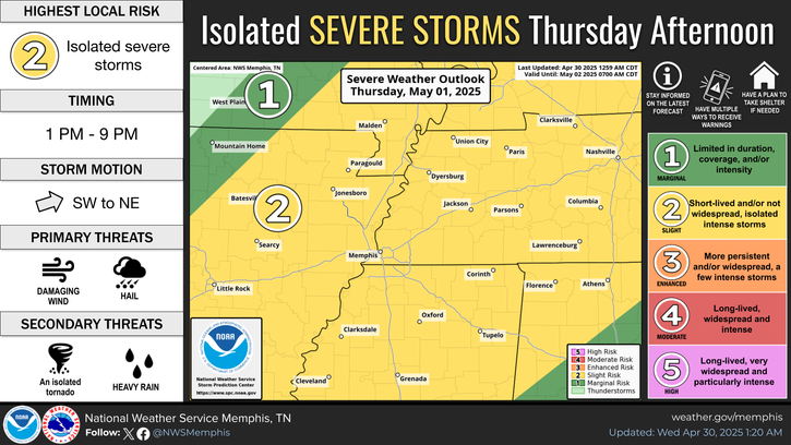
Heavy to excessive rainfall may produce areas of flooding Friday and Friday night from central Texas into the lower Mississippi Valley. Scattered strong to severe thunderstorms are expected from central Texas to middle Tennessee and central Kentucky Friday afternoon into early Friday night. Large hail and damaging winds are the main threats. Read More >

Click a location below for detailed forecast.

Last Map Update: Thu, May 1, 2025 at 11:26:22 pm CDT


A Sight (level 2/5) risk of severe storms is forecast for Friday afternoon and evening in areas along and south of I-40. Severe storms will be capable of damaging winds and hail.
A few thunderstorms tonight mainly over northern sections of the Mid- South. Lows in the low to mid 60s.
Numerous showers and thunderstorms expected Friday. Some storms could be severe with damaging winds and hail possible. Highs in mid 70s and lower 80s.

graphical hazard
Graphical Hazards
probabilistic
Probabilistic
current weather
Current Weather
be prepard
Being Prepared
estar preparado
Estar Preparado
safety
Weather Safety

Text Product Selector (Selected product opens in current window)

 Current Weather Observations...
Location Time
(CDT)
Weather Vsby.
(SM)
Temp.
(ºF)
Dewpt.
(ºF)
Hum.
(%)
Wind
(mph)
Wind Chill / Heat Index
(ºF)
Pres.
(in)
Memphis TN22:54Clear10716684SSW 13G21-29.93
Jackson TN22:53Clear10636193SSW 5-29.95
Jonesboro AR22:53Clear10696483SW 7-29.91
Tupelo MS22:53Mostly Cloudy10696483SSW 6-29.97
West Memphis, AR22:53Clear10706687SSW 6-29.91
Blytheville, AR22:53Clear10696380S 7-29.90
Dyersburg, TN22:56Clear10686487CALM-29.93
Olive Branch, MS22:5510696894SSW 10-29.93
Oxford, MS22:55Clear10686282SSW 10-29.99