National Weather Service United States Department of Commerce

Extreme Heat and Fire Weather Conditions in the West; Heavy Rain in the Southeast; Poor Air Quality

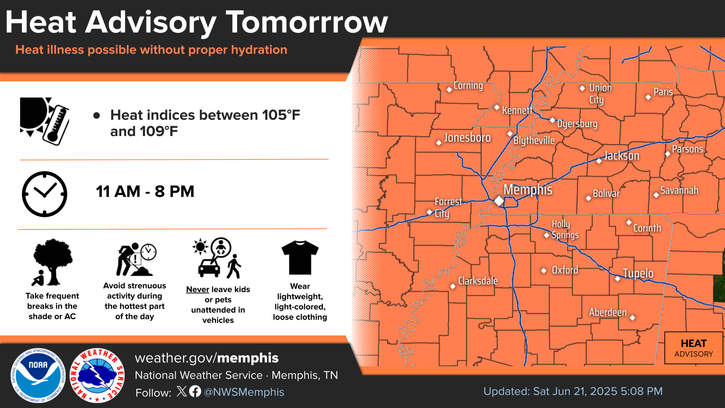
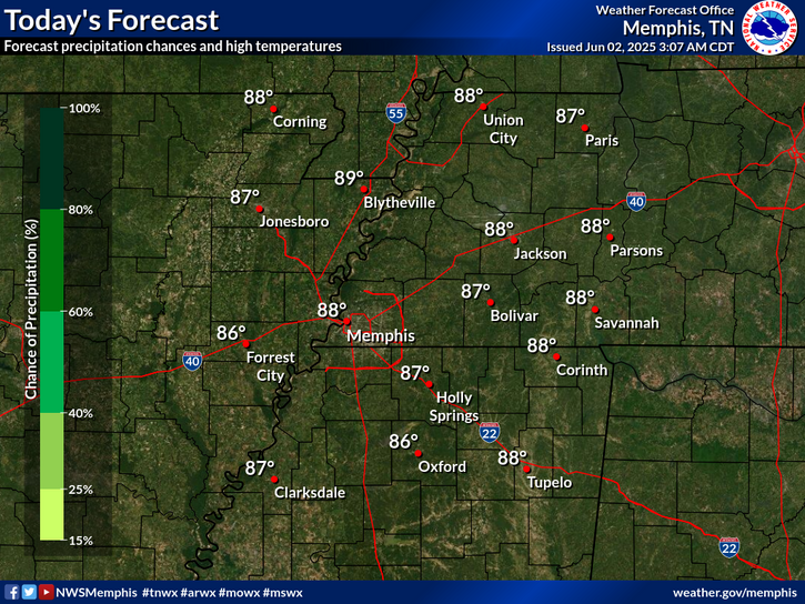
Extreme heat will begin to peak across the Desert Southwest. Multiple days of hot, dry and windy conditions are expected to bring fire weather concerns for portions of the Four Corners region into the central Great Basin and Rockies. Heavy rainfall and a flash flooding threat continues in the Southeast. Poor air quality persists from the Upper Midwest into the Northeast due to wildfire smoke. Read More >

Click a location below for detailed forecast.

Last Map Update: Wed, Aug 6, 2025 at 2:10:40 am CDT


Increasing temperatures will continue through the week. Humidity will also be on the rise and result in heat indices around 100 over most of the Midsouth by this weekend.
Low temperatures will gradually warm through late week, as humidity increases.

graphical hazard
Graphical Hazards
probabilistic
Probabilistic
current weather
Current Weather
be prepard
Being Prepared
estar preparado
Estar Preparado
safety
Weather Safety

Text Product Selector (Selected product opens in current window)

Hourly Weather Roundup ( )
Location Sky/Weather Temp Dewpt RH Wind Baro Remarks
Memphis, TN
N/A
N/A
N/A
N/A
N/A
N/A
N/A
Jackson, TN
N/A
N/A
N/A
N/A
N/A
N/A
N/A
Jonesboro, AR
N/A
N/A
N/A
N/A
N/A
N/A
N/A
Tupelo, MS
N/A
N/A
N/A
N/A
N/A
N/A
N/A
West Memphis, AR
N/A
N/A
N/A
N/A
N/A
N/A
N/A
Blytheville, AR
N/A
N/A
N/A
N/A
N/A
N/A
N/A
Dyersburg, TN
N/A
N/A
N/A
N/A
N/A
N/A
N/A
Oxford, MS
N/A
N/A
N/A
N/A
N/A
N/A
N/A
Note: "N/A" or "MISG" will be displayed if values are not available. In the LOCATION column, click on links for a list of recent observations at sites of interest. In the WIND column, VRB is "variable" and G is "gust". Wind speeds are in MPH. In the BARO (pressure) column, values are in inches. In the REMARKS column, HX is "heat index", WCI is "wind chill index", and VSB is "visibility" (if shown).