National Weather Service United States Department of Commerce

Slight Risk for Excessive Rainfall and Severe Thunderstorms Thursday

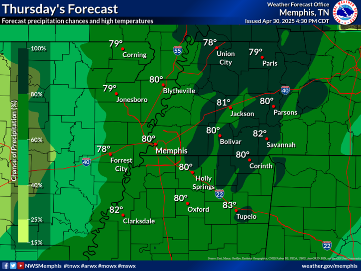
Additional rounds of thunderstorms are expected Thursday and Thursday night across Oklahoma and north Texas, with risks for both large hail and flash flooding. Strong winds may accompany any storms from east Texas northeast through the lower Great Lakes. Read More >

Click a location below for detailed forecast.

Last Map Update: Thu, May 1, 2025 at 2:18:13 am CDT


Numerous showers and thunderstorms expected Thursday. Some storms could be severe with hazards being damaging winds, hail, and the potential for an isolated tornado. Highs are anticipated to reach into the upper 70s and low 80s.

graphical hazard
Graphical Hazards
probabilistic
Probabilistic
current weather
Current Weather
be prepard
Being Prepared
estar preparado
Estar Preparado
safety
Weather Safety

Text Product Selector (Selected product opens in current window)

 Current Weather Observations...
Location Time
(CDT)
Weather Vsby.
(SM)
Temp.
(ºF)
Dewpt.
(ºF)
Hum.
(%)
Wind
(mph)
Wind Chill / Heat Index
(ºF)
Pres.
(in)
Memphis TN01:54Overcast10636193SSW 13-29.90
Jackson TN01:53Partly Cloudy10646189S 8-29.90
Jonesboro AR01:53Mostly Cloudy10656084WSW 17G30-29.85
Tupelo MS01:53Mostly Cloudy10675975SW 6-29.98
West Memphis, AR01:53Mostly Cloudy10636296S 16G24-29.87
Blytheville, AR14:53Partly Cloudy10856043S 15G23-29.90
Dyersburg, TN01:56Clear10646043S 8-29.87
Olive Branch, MS01:55Overcast106262100S 9-29.91
Oxford, MS01:55Overcast10626093S 9-29.98